| Home > All By Location regional map > Pittsburgh West > Mt Washington Transit Tunnel | |||
|
|
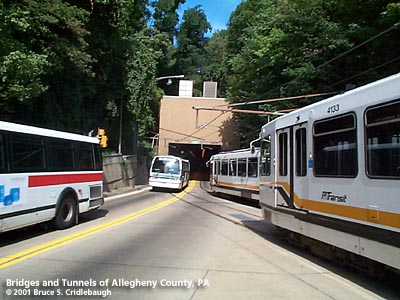
View inbound from South Hills Junction More detail photos OFFICIAL NAME: Mt Washington Transit Tunnel OTHER DESIGNATION: Mt Washington Trolley Tunnel Mt Washington Streetcar Tunnel LOCATION: Pittsburgh USGS 7.5" Topo Quad - UTM Coordinates: Pittsburgh East - Zone 17; 0584 4475 CARRIES: Port Authority "T" light rail vehicles; busway 2 lanes (2 tracks) BETWEEN: -- South Hills Junction near Warrington Av -- Carson St at Smithfield St UNDER: Mount Washington TYPE OF CONSTRUCTION / DESIGN: original tunnel: vertical wall horseshoe profile, concrete lining, bored through rock TOTAL LENGTH: 3,500 ft est OTHER DIMENSIONS: northern portal elevation: 760 ft est southern portal elevation: 1000 ft est [The USGS topo map shows a bend in the tunnel below Tuscola St, approximately 1,200 ft from the southern portal. Possibly a mapping inaccuracy.] YEAR OPENED / ENGINEER: 1904; Booth & Flinn, contractors; Pittsburgh Railways Co. 1985? reconstruction, Port Authority of Allegheny County ADDITIONAL INFO: The growth of Pittsburgh's earliest suburbs generally followed the Pennsylvania Railroad across the relatively level areas to the city's east: Shadyside, East Liberty, Wilkinsburg. Bridges over the rivers helped feed the towns in the North Hills and the near South Side. But Mount Washington posed a difficult wall to traverse and development in the South Hills was slow. The escarpment which is the front side of Mt Washington thrusts a 400 foot high barrier along the length of Pittsburgh's downtown. About a mile west, the outlet of Saw Mill Run in the West End provides the only natural cut through the full thickness of Mt Washington. Although the terrain becomes a bit gentler above the South Side Flats, the trailing remnants of Mt Washington still caused streets which have steps as sidewalks...or simply steps named as streets. Between the West End and the South Side, the only place where the topography relents is at Sycamore St on the front side paired with "The Hollow" at Warrington Av on the back side. It was in The Hollow that Jacob Beltzhoover opened coal mining operations in 1825. He sold coal to the city trade until 1835, and was succeeded successively by John Griffith and John D. Miller. The property was sold to Bailey, McKain & Co., in 1856, and in 1859 it passed into the posession of James M. Bailey who operated and ran out the remaining portion of the coal in the front hill in 1861, and sold to the Pittsburgh Coal Company. As new mines were opened on the south side of Saw Mill Run and southward toward Castle Shannon, a 40-inch narrow gauge railroad was constructed to carry the coal. In 1871 Pittsburgh & Castle Shannon Railroad was formed and in 1874 the line began to carry passengers in converted boxcars and later in coaches. The line included a tunnel which entered Mt Washington just above South Hills Junction and passed 1,741 feet to a incline station at Nimick St [now Neff St near the intersection of William St and Bailey Av]. In 1880 the tunnel was closed to passenger traffic which began to use a second incline on the back side of Mt. Washington, from South Hills Junction along Haberman Av to Bailey Av, with a short transfer to the front side incline. In 1893 (some sources quote 1877), William Flinn and his partner James J. Booth established a contracting company specializing in road building. Beginning in 1881, Flinn was elected to several terms in both houses of the Pennsylvania State Legislature, pushing for the "Good Roads Law" which taxed corporations to pay for such improvements. Completing his second term in the Pennsylvania Senate, Flinn, Peter Shields, and others, purchased sparsely populated farmlands on the hilltops of Beechview. In a typically symbiotic fashion for such ventures, Booth & Flinn built the Mt Washington Tunnel and Beechview streetcar line to spur the real estate development. Excavation began on April 6, 1903. Construction was completed October 7, 1904. The first trolley car passed through December 4, 1904. Construction for this new tunnel had begun about a year after the nearby Wabash railroad tunnel, but Booth & Flinn had made such quick progress that they were finished nearly simultaneously. The Pittsburgh portal of the streetcar tunnel aligns with the Smithfield St Bridge at Carson St and offers easy access into downtown. It is noted that this location once hosted 12 trolley lines, the Baltimore & Ohio and Pennsylvania railroads crossing above the portal, the Pittsburgh & Lake Erie Railroad's main terminal across Carson St, and the Monongahela Inclines (with both freight and passenger service until 1935). The southern portal, at South Hills Junction on Warrington Av, emerges a few hundred feet below and south of the old Pittsburgh & Castle Shannon Railroad portal. This Junction in "The Hollow" of Beltzhoover was a natural location for the convergence of traffic from four directions: the new tunnel, the Beechview line, an over-the-hilltop Knoxville line on Warrington Av, and the P&CS RR line which became the Overbrook line. When Pittsburgh Railways Company was formed to consolidate the various streetcar lines in the area, it took a long lease on the P&CS RR right-of-way with the exclusion of the old coal tunnel. In 1905, the P&CS RR line, now known as the Overbrook line, was upgraded with a dual gauge track and electrification to accomodate interurban passenger cars from Charleroi and Washington, PA, to share the line with coal shipments. Coal trains were restricted to night operation and discontinued in 1912. Though the interurban service ended in 1953, Pittsburgh Railways continued to operate trolleys through Castle Shannon to Library. On Christmas Eve, 1917, car 4236 ran away out of control down the 6 percent grade through the Mount Washington Tunnel. It overturned on Carson St, killing 21 and injuring 80. Settling injury claims resulted in the first bankruptcy of Pittsburgh Railways. It was reorganized at least twice more: 1937 and 1951. (Another runaway inbound trolley jumped the track October, 29, 1987. The vehicle crossed Carson St and came to rest against the Landmarks Building. Problems with the braking system were noticed in time to prepare for the impact, and though there were a few injuries, there were no fatalities.) The Port Authority of Allegheny County (PAT) was formed in 1956 to plan and develop the port facilities in the Pittsburgh area. The enabling act was amended in 1959 to extend the authority to the operation of privately owned transit facilities. In 1964, PAT exercised its powers of eminent domain and took control of the Pittsburgh Railways Company in addition to 30 independent bus companies. Trolley service continued on most of the lines which used the Mount Washington Tunnel. In 1974, PAT reduced the tunnel to a single track limiting trolley service to one way travel thru the tunnel in the predominant direction of rush hour travel. The tunnel was paved, lighted and ventilated to allow bus and trolley/light rail traffic to share the tunnel. On Sunday, October 26, 1975, trolley service in both directions was restored thru the tunnel. Bus traffic uses the tunnel to access the South Busway which was opened in December 1977. In 1980, groundbreaking was held near South Hills Village in Bethel Park for the Stage I Light Rail Transit program which sought to replace the South Hills trolleys with modern light rail vehicles. This phase of the program, known as the "T", included the construction of the downtown subway and a new transit tunnel in Mt Lebanon on the Beechview line. In 1984, the South hills trolley parking yard, which for decades had been at South Hills Junction, was moved to a new one next to South Hills Village. Also, in April 1984, the Mt Lebanon via Beechview line was closed and ground was broken for a total reconstruction. On Friday, May 22, 1987, the line reopened, completely modernized for light rail travel, from the old Castle Shannon Municipal building to the historic South Hills Junction. In July 1985, the subway and the line from Washington Junction to South Hills Village were the first sections of the "T" to open. By 1987 the final section of Stage I was opened through Beechview. At that time, two-car trains were introduced. Until 1999, the new vehicles from Adtranz/Duewag shared the line with a few survivors from the PCC trolley fleet which once numbered over 600 vehicles. Adtranz was the successor to Westinghouse which had designed the ill-fated Skybus system. Acquired by Bombardier Transportation in 2001, Adtranz also designed the rubber-tired people mover system for the Pittsburgh International Airport. Two "T" routes use the Mount Washington Tunnel. The 42L connects Pittsburgh's downtown subway to Library via Beechview. South of Castle Shannon, this once once part of the interurban line to Charleroi. The 42S also runs from the downtown subway through Beechview, then diverges at Washington Junction to follow another former interurban line, in part, to South Hills Village. Clinging high along the Saw Mill Run valley, the Overbrook line continued in operation using the older PCC trolley cars until 1993 when many of the old bridges were considered unsafe; the Stage II Light Rail Transit program to reopen the Overbrook line as part of the "T" began in 2000. FIELD CHECKED: INFO SOURCES: J. Sutton Wall, "Report on the coal mines of the Monongahela river region from the West Virginia state line to Pittsburgh, including the mines on the lower Youghiogheny river. Part I. Description of the mines." 1884; Port Authority of Allegheny County; Larry Woods; Jon Bell; Bob Dietrich; Roger DuPuis; Archy McNally; Harold A. Smith, "Touring Pittsburgh by Trolley"; Jim Holland Submit info or inquiry - share some facts or ask a question. Introduction -- Nearby Structures Page created: Last modified: 09-May-2002 |
View Larger Map View Larger Map 
| |
| copyright: © Bruce S. Cridlebaugh 1999-2008 All Rights Reserved | |||