| Home > All By Location regional map > Pittsburgh West > Point Bridge 1877-1927 | |||
|
|
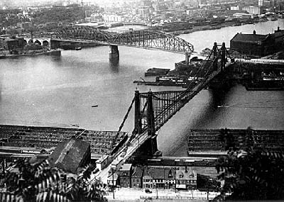
1915 Manchester Bridge (left) and 1877 Point Bridge. (Pennsylvania Department, Carnegie Library of Pittsburgh) 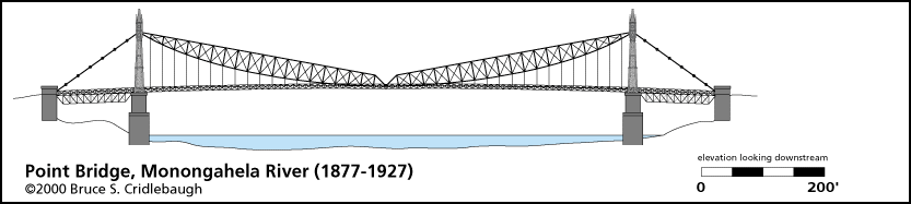
Elevation drawing looking downstream OFFICIAL NAME: OTHER DESIGNATION: Point Bridge LOCATION: Pittsburgh USGS 7.5" Topo Quad - UTM Coordinates: Pittsburgh West - Zone 17; 0583 4477 CARRIED: motor vehicles, street railway BETWEEN: -- right descending bank of Monongahela River the Point, Water St -- left descending bank of Monongahela River near the lower station of the Duquesne Incline, East Carson St CROSSED: -- Monongahela River at mile 0 TYPE OF CONSTRUCTION / DESIGN: Trussed eyebar suspension LENGTH OF MAIN SPAN: 800 ft center span; two 145 ft side spans TOTAL LENGTH (including longest elevated ramp): 1,090 ft HEIGHT OF DECK: 83 ft YEAR ERECTED / ENGINEER: 1877 ADDITIONAL INFO: Additional Info about historic bridges at Pittsburgh's Point. FIELD CHECKED: INFO SOURCES: HAER Submit info or inquiry - share some facts or ask a question. Introduction -- Nearby Structures Page created: Last modified: 20-Jun-2000 |
View Larger Map 
| |
| copyright: © Bruce S. Cridlebaugh 1999-2008 All Rights Reserved | |||