| Home > Articles > HAER PA-3: Pittsburgh Bridges at the Point | |||
|
|
Historic American Engineering Record Pittsburgh Bridges at the Point (PA-3, PA-4, PA-5) Page 1 of 2 -- Next Page
COVER PAGE
Historic American Engineering Record (HAER)
This record [PA-3] also serves as the historical report for PA-4 [North Side Point Bridge {Manchester Bridge}] and PA-5 [Point Bridge].
South Twenty-Second Street Bridge (Brady Street Bridge)
North Side Point Bridge (Manchester Bridge)
Point Bridge
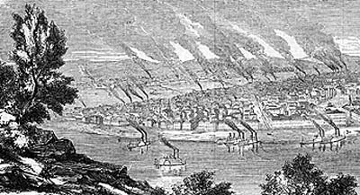
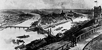
FOREWORD In Pittsburgh, everything begins at the Point in the flat peninsula of land between the two rivers that meet to form the Ohio. The land here thrusts away into the west, through and into the emergent waters, into the west which is a gate. That gate meant commerce and the opening of the continent beyond. The Point gave birth at first to ports, for the French, Duquesne; for the English, Pitt; the forts protected the developing commerce and having served their purpose, disappeared. Boats on the rivers were the earliest purveyors of commerce and for a season they carried the inhabitants of the Pittsburgh area across the dividing waters. But bridges became necessary, bridges -- those immemorial connectors -- were to appear at the Point, not at first, but gradually as the necessity for connection became apparent.
CHRONOLOGY
Union Bridge (across the Allegheny River)
Point Bridge I (across the Monongahela River)
Manchester Bridge (across the Allegheny)
Point Bridge II (across the Monongahela)
Fort Pitt Bridge (across the Monongahela)
Fort Duquesne Bridge (across the Allegheny)
South Twenty-Second Street Bridge (Brady Street Bridge) (across the Monongahela)
Jones' Ferry From the foundation of the first settlement at Pittsburgh until 1818 the only means of communication between the town and the further banks of the rivers was by canoe or skiff. As the settlement developed, some kind of ferry service became mandatory and in 1813 Jones' Ferry operated between the mouth of Liberty Street in Pittsburgh to the south bank of the Monongahela. Passengers were carried in skiffs while stock was taken over on flat boats. About 1840 the horse ferry was introduced in which blind horses, as a rule, were used as motive power -- they were made to tramp upon a horizontal wheel, the revolutions of which propelled the boat across the stream. A few years later Captain Erwin established a steam ferry from a point below the Point Bridge site on the south bank, but this was never a success. Subsequently the Jones' Ferry was abandoned and a steam ferry operated from Saw Mill Run on the south bank of Ohio to Penn Street in Pittsburgh. (1) This line was in use until the first Point Bridge was opened in 1877. (2)
Early Pittsburgh Bridges No attempts were made early in the nineteenth century to bridge the rivers at the Point. The first bridges built were the Smithfield Street Bridge across the Monongahela (called in its early days simply the Monongahela Bridge) erected in 1818, and the St. Clair Street (later Sixth Street) across the Allegheny opened a year later. (3) The former was a Burr-truss covered wooden bridge designed by Lewis Wernwag (4) and built by John Thompson. The Allegheny span was also of timber and covered. These bridges, which were conveniently situated for commerce, could not carry all traffic as the century advanced, and among other sites the Point began to be considered for new bridge construction. Another wooden truss bridge was constructed in 1840 at Hand Street (later Ninth Street) and at Mechanic's Street (later Sixteenth Street) in 1837 -- both across the Allegheny. (5) Near the present Eleventh Street the canal aqueduct was erected in 1834, which was superceded in 1844-45 by John Roebling's famous wire suspension aqueduct.(6) The Monongahela at Pittsburgh was not to be bridged by another highway span until the covered wooden bridge was built at South Tenth Street in 1861. At Pittsburgh the Ohio was unbridged until the twentieth century. In the late eighteenth and early nineteenth centuries the three rivers at Pittsburgh presented rather a different appearance. Before the introduction of dams toward the end of the nineteenth century, the rivers at slack water were relatively shallow, and numerous islands and sandbars were in evidence. There was, for instance, a long sandbar in the Monongahela at the site of the Smithfield Street Bridge and two islands Smokey and Kilbeck (Kilbuck), near the north bank at the confluence of the rivers. (7) It must be remembered also that there was an extensive traffic on all three rivers and the spans of the bridges had to be sufficiently high to allow boats to pass underneath them. The coal interests in Western Pennsylvania were also particularly concerned with navigation on the rivers, especially the Monongahela, because it was the chief means of transporting coal from the mines in the southwestern part of the state. (8) Certainly when bridges at the Point were projected, the claims of navigation had to be respected and the height of the span and an unobstructed channel at the mouth of the Monongahela were of interest not only to local commerce but also to the United States government and the United States Army Corps of Engineers who were charged with keeping the navigable streams unobstructed. (9)
Early Point Bridges - Early Proposals An important project in 1846 was to span the rivers at their junction with a tri-partite bridge, starting from the Point at the confluence of the two rivers, spanning with one trunk half of the breadth of the confluent streams and diverging on the breast of the bar into two trunks spanning also the Monongahela and Allegheny Rivers. A company was formed and chartered by the legislature (10) and stock subscriptions were called for, one gentleman putting his name down for $50,000. The structure was designed to cost $300,000, but only 500 shares at $500 each for a total of $250,000 were authorized. Rivermen and their friends combated the project on the ground that it would result in the obstruction to the navigation of the rivers. A resolution favoring the construction of this bridge passed the Pittsburgh Select Council by a majority of one and the Select Council by a majority of two. An opposing resolution was passed by the minority in both councils. It was freely predicted that the necessary subscription could not and would not be raised. Whether this was the cause of the failure of the enterprise or whether the numerous railroads then projected usurped public attention and thus smothered interest in the tri-partite bridge would be difficult to state; at any rate, neither the necessary stock was subscribed nor the bridge built. (11) No plans or drawings for this project seemed to have survived. According to another account the tri-partite bridge scheme was revived again in 1871. Charles Davis, the city engineer of Allegheny, Pennsylvania (12) submitted plans to a company formed at that time to carry out the project. (13) It will be noted that the estimated cost was nearly a million dollars, considerably more than the earlier bridge. The writer, in this case, also has been unable to locate any surviving drawings or plans. The undertaking failed only for want of proper support from parties who were directly interested in the bridge -- landholders whose property would have been greatly enhanced by the proposed connection.
The Union Bridge No more attempts were made to bridge both rivers at the Point with a single structure. Shortly after the abandonment of the tri-partite scheme, an association of citizens with Mr. Joshua Rhodes as president applied for and obtained a charter for building a structure known as the Union Bridge from Allegheny to the Point. This bridge, which may also have been designed by Charles Davis, was constructed in 1874-75 and opened to traffic in the latter year. (14) The Union Bridge was the last wooden highway river bridge constructed at Pittsburgh. It was a long Howe truss bridge with auxiliary arches and twin sidewalks. (15) There were elaborate portals at each end which Allen says were stone, but which were probably constructed of wood to represent stone. It was constructed in five spans whose numerous piers were undoubtedly an obstruction to navigation and this factor, together with the low clearance of the spans, caused the eventual demolition of the bridge in 1907. (16) A recent writer on Pittsburgh bridges, Mrs. Elizabeth Taylor Herbertson, has stated in her book that "the Manchester Bridge was also the site of the first rope span," (17) but this ambiguous statement has absolutely no foundation in fact. There was no bridge at the Point prior to 1874, as we have stated above.
The Point Bridge I: 1877 During 1874 while the Union Bridge was in process of construction, the question of a bridge to provide access from the Point to the South Side was much discussed in Pittsburgh City Councils. The Pittsburgh Daily Post reported on 16 June, 1874, that the first business of the Common Branch of Councils was to provide for a Point Bridge. "Certain individuals were opposed to the City erecting the bridge because of the great burden on the taxpayers. It was argued that the bridge might operate at a loss instead of paying for itself in a few years; were there enough residents at the Point to justify it -- also at Temperanceville (a small settlement at the south bank of the Monongahela)? It was also argued that the ordinance was merely a scheme to force bridge companies to sell and also a device of some politicians to court votes . . . Passage of ordinance lost when put to vote, but passage to be reconsidered." An ordinance requiring the City of Pittsburgh to erect a bridge -- which was, however, a compromise document -- was finally pushed through as reported in the Daily Post of 22 October, 1874. "At a meeting of the bridge committee held yesterday afternoon, the City Attorney was directed to prepare an ordinance empowering a private company to erect a bridge at the Point and collect toll for fifty years, at the expiration of which time the City will take possession at a price not exceeding the original cost." Accordingly, there would appear at the Point a structure destined to be unique in America -- a rigid suspension bridge. The Point Bridge Company was formed and a charter was obtained from the State dated 26 December, 1874. The directors were R. F. Smythe, H. Darlington, A. E. Painter, Jacob Henrici, Robert Marshall and Robert Stevenson and the officers were Joshua Rhodes, president; R. W. McConnell, secretary; George Crook, treasurer; Charles Davis, consulting engineer; P. F. Brendlinger, resident engineer. The survey for the bridge was begun in 1875. (19) The Engineering News account in its issue of 14 April, 1877, of the erection of the bridge, taken from the Pittsburgh Leader of 1 April, 1877, is undoubtedly the best and fullest extant chronicle of the undertaking, so we cannot do better than quote it extensively. The Company did try to take into account the factors applying to navigational interests on the Monongahela, and thus the Engineering News' account begins - - - "The difficulties encountered in the beginning of the undertaking can hardly be understood or appreciated by parties not directly connected with the work. The navigation interest exercised almost absolute control over the river, and was not to be conciliated by any measure short of one granting it an uninterrupted channel of the natural breadth of the river and with head room to admit of the largest sized boats passing under the bridge at an ordinary boating stage, for maneuvering their coal fleets. With such unreasonable conditions, and with the unfavorable topography of the banks in front of the city, it was no easy problem to make a design that would not obstruct the river, and at the same time give easy grades for the approaches to the bridge. The short level on the Pittsburgh side being only 27 feet above low water, while on the south side the banks comes abrupt against the water-line, with a railroad cutting its face and at an elevation of 70 feet above the river bed. The consulting engineer prepared no less than four plans to endeavor to harmonize the different conflicting interests and at the same time to get a practicable and economical construction. The president and consulting engineer of this company was before the coal exchange on several different occasions on this business; and only after several protracted interviews were they enabled to reach an agreement on the present plan. All these conflicting elements had to be harmonized in carrying out the design of and construction of the bridge. "Under ordinary circumstances bridging the Monongahela would have been of trivial importance." The plan adopted would have necessitated an artificial approach on the north side of a depth of some fifty feet at the abutment and some six feet deep at the foot, The approach is about 1,000 feet long, and extends along the wharf outside of Water Street to Penn Avenue, and along Penn Avenue to Point Alley, giving an easy ascent to the bridge. An approach connecting the two bridges will be formed by filling up the Point. The plans for the work were approved in May, 1875. The Point Bridge Company invited bids for building the bridge in May of 1875, with the understanding that they might be for cable suspension, according to specifications and plans prepared by their consulting engineer, which called for an 800 foot middle span and two independent side spans of 145 feet each or for any other plan. Proposals were made by most of our most prominent bridge builders of the country, among whom were Roebling Sons and the Keystone Bridge Company of this city, based upon various plans, viz: Cable suspension, braced arch, Ordish system, cantilever, unstiffened and stiffened chain suspension. In selecting the proper plan the directors and engineer of the Point Bridge Company were well aware that their bridge was of unusual dimensions and they took care not to adopt an experimental plan. The only long span bridges in the world to compare with the requirements of the Point Bridge were the Niagara railroad bridge and the Cincinnati bridge, both being wire-cable suspension, built by Mr. John Roebling, with 820 foot and 1057 foot spans respectively, and the chain suspension bridges -- one, the Clifton bridge over the Avon, in England, 702 feet long, and the one across the Danube at Pesth, Austria, which has a span of 666 feet -- all other long span bridges being either of less length or are only built for light traffic. The plan finally adopted was a stiffened chain suspension bridge, submitted by the American Bridge Company of Chicago (20) and designed by their chief-engineer, Mr. Edward Hemberle. (21) This plan represents all the good features of a modern chain suspension bridge and has, in addition, a novel stiffening system, which, as far as theoretical investigations and judgment can determine, seems to obviate all the faults of wire-cables and of the formerly built chain suspension bridges. In ordinary suspension bridges the roadway is suspended by hanging rods from chains or cables which stretch from pier to pier. In such a structure the chains or cables and the platform are flexible longitudinally, and this is shown whenever the bridge is loaded at one end more than at the other by a moving load, or is subjected to wind pressure from above or below. To improve the suspension bridges in this respect has been the aim of many engineers. The simplest improvement has been effected by keeping the points of the curved chain or cable which are more liable to deformation in their proper places by attaching them to the top of the towers by straight chains or wire-rope stays, which plan was first adopted by Ordish in Europe and by Roebling in this country. A method for rendering the chain itself rigid has been attempted by dividing it into two parts, placed one above the other and bracing them together. A railway bridge upon this system, with a span of 260 feet, is in actual use in Vienna, in Austria, but would not be efficient for a long span. A system according to which a single chain is connected to the platform of the roadway by bracing was adopted in the construction of Lambeth bridge across the Thames in London, having spans of 180 feet, built in the year 1862, and in a footway Bridge over the Main at Frankfort, Germany, of 262 feet span in 1869. This system properly improved may fulfill all the requirements to ensure stiffness; but in long spans the bracing between roadway and chains will have to be of such great length as to make it ineffective and expensive. Mr. Hemberle's plan, as represented by Point bridge, consists of towers, chains with platform suspended there-from in the same manner as in a regular chain suspension bridge; In addition thereto is a stiffening system above the chains, and are rigid posts arranged between chain and platform to prevent the roadway to undulate or oscillate independent of the structure above. The stiffening arrangements above the chains consist in rigid chords running in straight line from the top of the towers toward the center of the chain, and being connected thereto by a hinged joint at each end. Between these chords and the chains is a system of bracing, consisting of posts and diagonal tie-rods. All connections are pin-jointed. The chain, being a catenary or curve of equilibrium, takes up all the permanent load of the structure, without bringing strains on the stiffening trusses. This object was accomplished by erecting the bridge completely before connecting the ends of the straight top chords to the center joint. The rods are provided with turn-buckles, and are so adjusted as to be strained under moving load only. When the bridge is half-loaded the top chords of the trusses on the loaded side will be in compression and the unloaded side in tension. There are lateral and vibration braces between the top chords and also between the chains, proportioned to take up the strains from wind pressure upon the strains and trusses. A model of Point bridge was exhibited at Philadelphia and received an award, and Mr. Hemberle was the recipient of quite a number of complimentary letters from most prominent American and foreign engineers approving his new plan. (22) The total length of the Point bridge is 1,245 feet from back to back of the anchorages, with one middle span 800 feet between center of piers, and one independent-trussed side span of 145 feet in length at each shore. The roadway rises from both shores toward the center of the channel with grades not exceeding 3 feet in 100 -- the highest point of the roadway being 83 feet above low water. The saddles upon which the chains rest on top of the towers are 180 feet above low water. The deflection of the chain is 83 feet, which is considerably more than usual for suspension bridges, but the stiffening allows of increasing the deflection and thereby reduces the strains in the chains and their weight. The bridge is 34 feet wide from center to center of outside rails and the space is divided into a roadway 21 feet wide and two sidewalks of 5 feet each by inside iron handrails. The piers up to the roadway and the anchorages are built of masonry. They are founded upon timber platforms sunk to a gravel bed below low water. The masonry is of the best quality -- Baden sandstone laid in cement mortar. The towers are entirely of wrought-iron except the bases of the columns. Four columns each 30 inches square braced together by lattice work form the support for each chain, which carried at the top of the towers on wrought-iron saddles, which are movable on steel rollers to allow for expansion and the elongation of the back chains under strain or from changing temperature. The chains are formed of link bars, 20 ft. 6 in. long, varying in size from 8 by 2 inches to 8 by 1 inch, connected by pin bolts 6 inches in diameter. There are 12 and 13 bars alternately in the back chains, and 11 and 14 bars in the main chains. Stiffening trusses on top of the chains are 22 feet high in the middle and their upper chord is box-shaped with full rivet splices to resist tension as well as compression. Outside of the floor are roadway trusses 8 feet high, part above and part below the floor. They are built continuous in lengths of 100 feet, and are jointed together at their in-ends in such a manner as to allow for expansion and contraction of the iron work. These trusses are suspended from the chains by iron rods placed in pairs every 20 feet and by rigid posts every 100 feet. Iron cross girders, 3 feet in depth, connect these roadway trusses every 20 feet and support two intermediate lines of iron stringers. These stringers and the roadway trusses form the bearers across which are placed the wooden joists for the flooring. The roadway consists of two courses of 2-inch oak planks, the lower course being laid diagonal and the upper lengthwise to the bridge. Two street-car tracks are laid upon the floor. The side-walks are laid with narrow 3-inch plank of southern pine. The lateral stiffness of the floor is secured by a double system of tie-rods and the wind pressure is taken up by four horizontal steel wire cables, placed under and connected to the floor. The specifications for the Point bridge call for a moving load of 1,600 lbs. per lineal foot, to be carried by the structure in addition to its own weight, with a factor of safety of 5, that is, it would require five times the above load to break the bridge down. The 1,900 lbs. per lineal foot is for the 800-foot span, equal to 1,280,000 lbs. which weight is equal to 16 locomotives or equal to the weight of a crowd of 9,000 good-sized people. Such a load is very unlikely ever to come on the middle span of the bridge, and five times that load would not injure the iron works. The back chains on each of the bridge have a sectional area of 384 square inches, and were all put to actual test of 10 tons per square inch without showing any injury, which will make their reliable supporting power equal to 3,840 tons. For the floor system and the suspenders the proof load is taken at 896 tons for the middle span. There are 156 suspension-rods carrying the floor, each with a strength of 47 tons, as proved by actual tests which will make their supporting power equal to 7,132 tons, which is equal to the weight of 180 locomotives. Each of the towers has a sectional area in columns of 504 square inches, and their resistance against failure under the load would be equal to 10,080 tons, whereas the load which ever may come on is only 1,800 tons. The lateral cables under the floor are at each side, double 2-inch cast-steel wire ropes, each having an ultimate strength of 210 tons. They would resist the greatest strains brought sideways against the bridge in case of a hurricane, and the bridge has already, under severe winds, proved to be absolutely rigid sideways. The total cost of the bridge is about $525,000, which is very low compared with other structures of the same magnitude; Cincinnati bridge, being only 200 feet longer, cost $1,800,000. The chain suspension bridge at Pesth, Austria, having a middle span of 666 feet only, cost $2,700,000. St. Louis railway bridge, having spans of 520 feet, cost seven millions. The president and directors of the Point bridge company deserve great credit for the manner in which they conducted this enterprise. It is due to their efforts and management that this bridge was finished in such short time and at so small cost compared with other bridges in this and other countries. The American Bridge Company of Chicago, H. A. Rust, president, presented not only the best plan, but also were among the lowest bidders, and the contract was awarded to them for the whole structure complete. The American Bridge Company transferred the contract for the masonry and the foundations to John Megraw, of Allegheny, who has done his share of the work in the most satisfactory manner, and is right in claiming to have the best job of mason work done along our rivers. The award of the contract to an outside company created quite a feeling amongst the Pittsburgers, who are right in claiming their superiority in manufacturing of iron-work, and it may be quite a satisfaction to them that after all most of the work has been done here, with the exception of the forged linkbars in the anchorages and parts of the iron-work, for the manufacture of which the American Bridge Company have special tools in Chicago, all the iron-work was manufactured by Pittsburg parties. Graff, Bennett & Co., furnished the iron in quality unrivaled for the purpose. It is superior in strength and other qualities required for bridge iron to the manufacture of parties making bridge iron their speciality. Mr. Williams, the superintendent of their mill, deserves a great deal of credit for his efforts in obtaining for the unusual large bars a quality of the iron in strict conformity with the specifications. The manufacture of the iron-work was done at the Pittsburgh Locomotive Works, under the supervision of the American Bridge Company's agents. The manufacture of the large link-bars was, after some experimenting, brought to perfection, so as to insure the same strength throughout the entire bar and eyes, which before has been only obtained by the process of Mr. Sellers at Edgemoor. On July 1, 1875, work was commenced, and by the following winter the masonry was well advanced. Early in the spring operations were again resumed and continued without interruption to the present date. A great deal of the most difficult work, such as the stiffening-truss, was prosecuted in mid-winter, with the thermometer ranging near zero, and with heavy winds prevailing. Much of the time the material was covered with snow and ice. The rough weather severely taxed the endurance of the men, but in no instance did it get the mastery. Much credit is due Mr. George C. Thorn, superintendent of erection, for the masterly manner in which he conducted the work through such adverse circumstances, and without the occurrence of any accident. The specifications were drawn with considerable minuteness and required very rigid tests for iron. The links were to be made of the best quality of double refined iron, and in addition to other tests were submitted to a proof strain of ten tons per square inch, sectional area, before they were admitted into the chains. This testing, as well as the inspection of the work, and the giving of levels and distances connected with the bridge, in compliance with the specifications, was entrusted to the resident engineer, who was also the estimating engineer. The records of the iron test have been carefully preserved, and form a valuable record. The quantities of the material used in the construction of the bridge are as follows, viz: Timber in foundations, 1,442,000 feet, board measure. Masonry in anchor-walls, 1,868 cubic yards Masonry in piers, 7,507 cubic yards. Iron in foundations, 12 tons. Wrought-iron in superstructure, 2,084 tons. Cast iron in superstructure, 52 tons Steel in superstructure, 32 tons Timber in superstructure, 810,000 feet, board measure. Number of links in the chain, 1,832. As an immediate result of the building of the bridge we should note the approaching completion of the Duquesne Inclined Plane designed to overcome the gradient of Coalhill, and so situated as to connect with the Point bridge. And yet another, in the proposed street car railway, starting from Fifth Avenue and Liberty Street then along either Penn or Duquesne Way to the bridge, across the bridge to Carson Street, along the same to Saw-mill Run and continued to the Old Stone tavern. The Point Bridge Company are already engaged in constructing a portion of this line connected with the bridge and approaches on their own account. Also another improvement, diverting travel through new channels, in the shape of a proposed freight and passenger depot for the Panhandle R.R., at the terminus of the bridge. It is impossible to calculate the benefits to be derived by the different portions of the city in the increased facilities for intercourse afforded by the erection of this bridge. It will undoubtedly restore the old part of Pittsburgh about the Point to its former vitality, and will greatly contribute to the speedy development of heretofore almost inaccessible territory on the South Side. By such schemes of internal improvement at this, the thrift and general prosperity of the city is enhanced, and additional comforts to the citizens secured. And we have no doubt that the parties interested in the construction of the bridge will be amply repaid in this investment. The bridge will not be open for general traffic before ten days, the approaches not being finished yet. The bridge itself is completed, except the finishing of the hand-rails and the ornamental work of the towers. The ornamental work of the towers will be done quite elaborately and it will greatly add to the beauty of the structure. It is to be of galvanized iron, and the work, already done by Messrs. Stevenson & Cartwright, of Allegheny, awaits only good weather to be put in place. Two more coats of paint are to be put on the bridge as soon as continuous good weather can be expected. The bridge was opened in April 1877. The light construction of this bridge was, however, in the end a drawback because the company did not maintain it properly. It was hardly in safe condition when the City of Pittsburgh acquired it in 1896, as the result of an ordinance introduced into City Councils in 1895. A Board of Viewers considered $420,0230 as a fair price for the span, but the City acquired it for $400,000. (23) The clamor for "free" bridges in Pittsburgh had by now become insistent and the Point Bridge was the first local span to be municipally acquired as the South Twenty-Second Street Bridge of 1895-96 was the first to be constructed by the City. A thorough inspection of the Point Bridge was undertaken in 1897 by John Brunner for E. M. Bigelow, (24) the Director of Public Works of the City of Pittsburgh, but no appropriation could be obtained for executing repairs. In 1901 Brunner's plans were revised by Willis Whited, assistant engineer of the Department of Public Works, but no action was taken until December 1903 when it was discovered that three floor beams were broken and the bridge was then closed to heavy traffic and a $92,000 contract was made with the Pittsburgh Construction Company for complete repairs. (25) Reconstruction work was begun 1 June, 1904, and completed 28 November, 1904. The anchor piers were taken down and rebuilt and all cables were examined and strengthened. Stay bolts and anchor bolts were renewed so as to tighten the entire structure and whole bridge was painted and refloored. Ornamental sheet metal domes were substituted for the former light grill work at the top of the suspension towers. Strengthened though it was, the engineers conceded that the bridge was still fragile and would eventually have to be replaced. (26) Even so, for many years the delicate web of the first Point Bridge rose above the confluence of the rivers, its large suspension towers like cathedral turrets soaring against Pittsburgh's sulphurous skies. The writer, as a small child, remembers motoring across it on a foggy morning in 1915 and the passage was like a dream as we proceeded in the old high-slung motor car through the truss and cables as through notes and bars of music. The great bridge was essentially a sonata, a poem, the music and poetry of the engineers, flung into the air by some calculated and yet incalculable sorcery and it achieved an effect perhaps never envisioned by its "practical" designers long vanished now; long vanished too, it lingers in the memory as something strong and beautiful and good, an ambassador of grace to the manufacturing principalities of nineteenth century Pittsburgh. But, alas, all its poetry could not save it (the same could be said for many other engineering triumphs of the nineteenth century) and by the early 1920's it was more than evident that its days were numbered. In 1924 the bridge was closed to heavy traffic and in January of that year a mass meeting was held by the citizens of the West End, a large suburban area on the south bank of the Monongahela, to advocate prompt action by Allegheny County in building a new bridge. (27)
Page created:
|
||
| copyright: © Bruce S. Cridlebaugh 1999-2008 All Rights Reserved | |||