| Home > All By Location regional map > Pittsbugh East > Heth's Run Bridge | |||||||||||||||
|
|
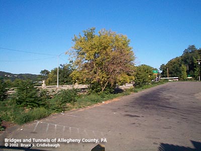
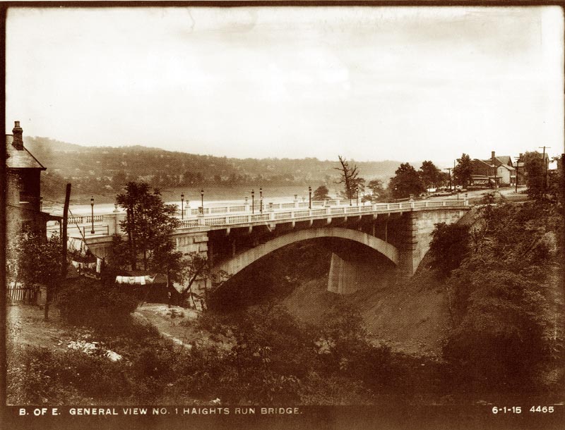
OFFICIAL NAME: Heth's Run Bridge Haight's Run Bridge OTHER DESIGNATION: Allegheny River Blvd No. 1 Butler St over Heth's Run LOCATION: Pittsburgh USGS 7.5" Topo Quad - UTM Coordinates: Pittsburgh East - Zone 17; 0591 4482 CARRIES: -- Butler St BETWEEN: -- Baker St, Morningside, Pittsburgh -- One Wild Place (formerly The Hill Rd), Highland Park, Pittsburgh CROSSES: -- Heth's Run (partially buried) TYPE OF CONSTRUCTION / DESIGN: Reinforced concrete open spandrel deck arch LENGTH OF MAIN SPAN: 255 ft TOTAL LENGTH (including longest elevated ramp): 327 ft HEIGHT OF DECK: partially buried YEAR ERECTED / ENGINEER: 1914, City of Pittsburgh T. J. Wilkerson, engineer Stanley L. Roush, architect PennDOT, current owner ADDITIONAL INFO: In the years following the 1889 opening of Pittsburgh's first parks, Highland and Schenley, the city was busy building boulevards to connect them. Owing to the terrain, the dimensions of the bridges built along these promenades were monumental; owing to the custom of the day, the architectural designs were monumental as well. Three metal arch bridges over 350 ft -- Schenley, Panther Hollow, and Wilmot St -- gave first access to the isolated Schenley Park. A later concrete arch of just under 300 ft carries Beechwood Blvd out of the park. Following Beechwood Blvd northward, then into the valley of Washington Blvd, motorists passed below the rusticated arches of Lincoln Av and the longest concrete arch span in the world carrying Larimer Av. Near its northern terminus, Washington Blvd curled along the shore of the Allegheny River to meet Butler St near Heth's Run. There are two gateways to Highland Park. Judging by the statuary and columns at the Highland Av entrance, the lower park entrance from Washington Blvd is the back door. But this may be a modern misconception: the monument to signal the northern entrance to Highland Park was built in 1914 -- but left to die and endure a slow burial. This fate is not unique in Pittsburgh. The city built two other picturesque bridges for their parks, each of which are now hidden: the stone arch Bellefield Bridge at the Schenley Plaza entrance to that park and the stone arch bridge carrying Lake Dr over a now-filled ravine near Highland Park's Lake Carnegie. view page - Bellefield Bridge over St Pierre's Ravine, buried view page - Lake Rd near Connecting Rd, stone arch over filled ravine, buried And so it has come to pass, that the grand white structure which marked the northern entrance to Highland Park and the Pittsburgh Zoo has decayed to a degree that it is barely recognizable for what it is -- or more accurately -- what it was. Opened in 1914, the Heth's Run Bridge is a structurally simple concrete arch. It has two arch ribs each holding eleven vertical spandrels. False quoins are molded into the corners of the abutments -- but these are all but obscured in burial. The most impressive features of the bridge lay along the deck. Stanley L. Roush, architect for many city and county structures, used white limestone in the form of some 360 carved ballusters and 14 urns in decorating the ballustrades. All of the carved pieces along the southern side of the bridge were removed (1970s-1980s?) and replaced with a functional, but boring, aluminum railing. The northern ballustrade was spared this destruction, but time and the elements -- which likely brought about the stripping along the southern side -- have ravaged what remained. Large sections of the northern stone ballustrade have crumbled, disintegrated, and fallen into the now-shallow ravine of Heth's Run. Missing sections have been "patched" with all manner of wood and metal scraps. Roush's ornamental lampposts are all missing as well. Near Baker St at the western portal to the bridge, the predecessor to the 1938 Highland Park Bridge once met Butler St. The cantilever truss Aspinwall-Highland Park Bridge brought traffic across the Allegheny River beginning in 1902. At the western portal of the Heth's Run Bridge, there are two pylons. The northern one retains its builder's plaque:
Other projects completed by Superintendent N. S. Sprague and engineer T. J. Wilkerson include the 1914 cantilever deck truss Bloomfield Bridge and the 1915 through truss Manchester Bridge spanning the Allegheny River at Pittsburgh's Point. Thomas J. Wilkerson went on to engineer the famous "Three Sisters" at Sixth, Seventh and Ninth Sts (1925-28) over the Allegheny River for Allegheny County Dept. of Public Works. This trio of bridges is noted for it ingenious use of cantilever construction to build a self-anchoring suspension structure in which the eyebar catenaries are supported by the rigid piers rather than anchorages at the portals. Architectural echoes of the Heth's Run Bridge may be found in other Pittsburgh bridges. Eight years later, Architect Stanley L. Roush used decorative urns atop the Beechwood Blvd Bridge built by the City of Pittsburgh as one of the monumental entrances to Schenley Park. Nearby in the park, the 1897 Panther Hollow Bridge still retains a few of its carved stone ballusters which have a similarity to those which have all but crumbled and vanished from Heth's Run. A green stained rectangle on the southern pylon marks the former location of a smaller commemorative plaque erected in 1919 by the Daughters of the American Revolution:
The plaque is not entirely accurate; Heth's land did not extend as far as the bridge. The source of Heth's Run is in East Liberty on land once owned by Henry Heth (also spelled Haight). But in its northward course to the Allegheny River, Heth's Run carved a broad ravine which was owned by Hon. James Ross, one of the first nine members of the Allegheny Bar Association and for whom Ross St in downtown Pittsburgh is named. The stream outflow and the location of the Heth's Run Bridge are within the bounds of lands once owned by Alexander Negley. Negley's estate included nearly the entire area of present-day Highland Park; there is a monument to his family in the park. Over the course of the years, the Heth's Run ravine was acquired by the City of Pittsburgh for storage facilities, recycling and waste disposal, and dumping of excess dirt. With various expansions of the Pittsburgh Zoo which overlooks the ravine, the continued filling created space for parking lots. One of the world's longest outdoor moving walkways once carried zoo visitors up the eastern side of the valley; it has been replaced by more modern ticket offices, elevators and escalators. The filling of the valley continued -- extending the Zoo parking lot further north -- obscuring the sideview of the Heth's Run Bridge. Only a small space below the bridge remains unfilled. The valley which once required a 255 ft bridge is now all but gone. The Heth's Run Bridge is slated for repair or replacement. With its deck ornamentation ravaged and underclearance nearly gone, it seems not much left. The construction of the 1938 Highland Park Bridge cleared homes to the east of the Heth's Run and caused a misalignment of the multiple lanes of traffic. The bridge's decay has led to further lane restrictions on the Heth's Run Bridge. Historic preservation seems to face a battle; it would be simpler to replace the entire structure with a covered pipe or culvert. Heth's Run has become Heth's Ruin. Perhaps there are parts of the bridge which could be saved and reused. And Highland Park's northern entrance could be more than a ghostly resemblance of what it once was. FIELD CHECKED: 19-Sep-2002 INFO SOURCES: Collin, "Stringtown on the Pike"; Kidney, "Pittsburgh's Bridges" Submit info or inquiry - share some facts or ask a question. Introduction -- Nearby Structures Page created: Last modified: 29-Jan-2003 |
View Larger Map View Larger Map 
| |||||||||||||
| copyright: © Bruce S. Cridlebaugh 1999-2008 All Rights Reserved | |||||||||||||||