| Home > All By Location regional map > Pittsbugh East > Highland Park Bridge 1902 | |||
|
|
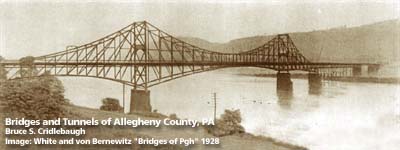
1928 photo, view downstream 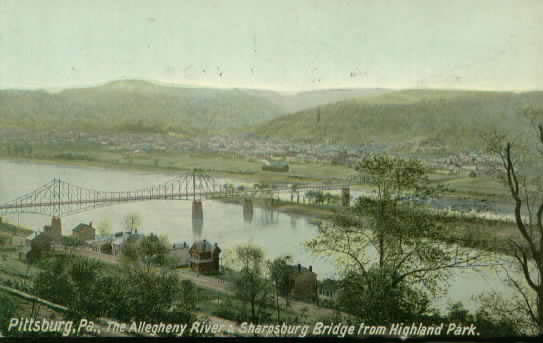
Postcard, view downstream OFFICIAL NAME: OTHER DESIGNATION: Highland Park Bridge Aspinwall-Highland Park Bridge Sharpsburg Bridge LOCATION: Pittsburgh - Sharpsburg USGS 7.5" Topo Quad - UTM Coordinates: Pittsburgh East - Zone 17; 0592 4482 CARRIED: motor vehicles and street railway, 2 lanes BETWEEN: -- 19th Street (Sharpsburg) on right descending bank of Allegheny River -- Butler St at Baker St (Pittsburgh) near western end of Heth's Run Bridge on left descending bank of Allegheny River CROSSED: -- Allegheny River at mile 6.6 -- Six Mile Island (also known as Guyasuta Island) TYPE OF CONSTRUCTION / DESIGN: cantilever through truss LENGTH OF MAIN SPAN: 850 ft TOTAL LENGTH (including longest elevated ramp): 1,850 ft HEIGHT OF DECK: YEAR ERECTED / ENGINEER: 1902, Herman Laub ADDITIONAL INFO: The first Highland Park Bridge is shown on the 1907 USGS map, crossing from near the tunnel under the railroad at 19th St, Sharpsburg, to a landing on Butler St at Baker St near the western end of the 1914 Heth's Run Bridge (Haight's Run). This older bridge is shown crossing the downstream tip of Six Mile Island, but the streets and island do not align as shown on the USGS map. This seems to indicate that Six Mile Island has moved downstream a distance roughly equal to it present length, so that the upstream tip now lies where the bridge would have crossed. A description of the bridge appeared in "History of Bridges" by Henry Grattan Tyrrell in 1910. The following is a summary: "Two lanes which included two streetcar tracks, and two footwalks with an outside width of 36 feet and a total length of 1,850 feet. The 850 foot cantilever span took 700 tons of steel, while the whole bridge contains 1,259 tons, costing with substructure $175,000. Herman Laub was the engineer. The trusses were 24 feet center to center. The anchor truss was made up of 8 panels of 25 feet each + 200 feet. The cantilever span was 6 panels of 25 feet each and (the suspended span of) 3 panels of 25 feet each to the centerline of the bridge. The road and sidewalks were pitched at 3.25% grade to the center. The truss was an eyebar truss with the top chord being in an approximation of a catenary beginning at rail level at the anchorage, rising to an apex 90'-1'' at the span pier and declining to the centerpoint which was about 18 feet above the rail level at the center. The bottom chord was a shallower mirror image of the top chord. The truss was 25 ft deep at the center."A ferry is shown on maps about 1/2 mile upstream from the location of this bridge. Lock and Dam No. 1, built in 1902, was located at 21st St. It was removed when the Emsworth Dam (1922) was built, thus providing the pool for the Pittsburgh Point area up to the Highland Park Bridge area. Built upstream of the first Highland Park Bridge, Lock and Dam No. 2 was opened for navigation in 1934. The bridge was replaced by the 1938 Highland Park Bridge. FIELD CHECKED: INFO SOURCES: White & Von Bernewitz, "Bridges of Pittsburgh", Henry Grattan Tyrrell, "History of Bridges", Randolph Chalfant Submit info or inquiry - share some facts or ask a question. Introduction -- Nearby Structures Page created: 11-Sep-2002 Last modified: 13-Sep-2013 |
View Larger Map 
| |
| copyright: © Bruce S. Cridlebaugh 1999-2008 All Rights Reserved | |||