| Home > All By Location regional map > Pittsbugh East > WPA bridges on Lake Trail | |||
|
|
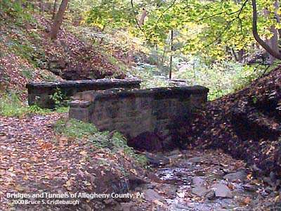
Bridge E More detail photos OFFICIAL NAME: OTHER DESIGNATION: WPA bridges on the Lake Trail (11 structures) LOCATION: Pittsburgh (Schenley Park) USGS 7.5" Topo Quad - UTM Coordinates: Pittsburgh East - Zone 17; 0589 4776 CARRIES: pedestrians, Lake Trail BETWEEN: -- CROSSES: -- stream in Panther Hollow TYPE OF CONSTRUCTION / DESIGN: stone and fill over concrete pipe, stone facing LENGTH OF MAIN SPAN: TOTAL LENGTH (including longest elevated ramp): HEIGHT OF DECK: YEAR ERECTED / ENGINEER: 1938-39, Works Progress Administration ADDITIONAL INFO: Just above Panther Hollow Lake, two small streams emerge from the bifurcated Hollow. Nearly a dozen small bridges cross the two streams. One of these branches extends northward to the Tufa Bridge below the Visitor Center. This trail suffers from neglect and flood damage and is nearly impassable. The other stream flows from the east from the area near Barlett Dr. Higher on the sides of this hollow are the Upper and Lower Panther Hollow Bridle Paths. Along the stream, the Lake Trail links the Bridle Path to Panther Hollow Lake. Today, the Lake Trail meets the Bridle Path after crossing the stream on a stone-faced culvert [H] built by the WPA in 1939. A primitive stairway leads back into the bottom of the ravine -- allowing access to the remains of the old Lake Trail. This trail mirrors the zig-zagging of the stream -- crossing and recrossing -- with a series of small bridges. The bridges were built in 1938 and 1939 and were constructed using stone and fill over concrete pipes. Bridge F has been damaged by flood and the construction methods are easily visible. Bridge C is one of the better preserved structures, but there is a jumbled pile of cut stones downstream where another bridge may have been erased by flood. Beyond bridge B the trail disappears, having been neglected for so long and reclaimed by nature. Near the top of the eastern branch of Panther Hollow, bridge A is nearly buried in silt just downstream from the Tufa Bridge below Serpentine Rd. Bridge A once led to the upper end of the Lake Trail, but is now just a shortcut between the two halves of the Bridle Trail. Near the intersection of the Upper Bridle Trail and the Steve Faloon Memorial Trail, there is evidence of an old quarry site -- possibly a source for the stones used to face the bridges. From Britannica: "The Works Progress Administration was a work program for the unemployed that was created in 1935 under U.S. President Franklin D. Roosevelt's New Deal. While critics called the WPA an extension of the dole or a device for creating a huge patronage army loyal to the Democratic Party, the stated purpose of the program was to provide useful work for millions of victims of the Great Depression and thus to preserve their skills and self-respect. The economy would in turn be stimulated by the increased purchasing power of the newly employed, whose wages under the program ranged from $15 to $90 per month." "During its eight-year existence the WPA put some 8.5 million people to work (over 11 million were unemployed in 1934) at a cost to the federal government of approximately $11 billion. The agency's construction projects produced more than 650,000 miles (1,046,000 km) of roads; 125,000 public buildings; 75,000 bridges; 8,000 parks; and 800 airports. The Federal Arts Project, Federal Writers' Project, and Federal Theater Project--all under WPA aegis--employed thousands of artists, writers, and actors in such cultural programs as the creation of art work for public buildings, the documentation of local life, and the organization of community theatres. The WPA also sponsored the National Youth Administration, which sought part-time jobs for young people." "In 1939 the Works Progress Administration altered its name to Work Projects Administration. In that year increasing charges of mismanagement and of abuse of the program by workers led to a reduction in appropriations, and a strike by construction workers against wage cuts was unsuccessful. In 1943, with the virtual elimination of unemployment by a wartime economy, the WPA was terminated." view page - More information about the WPA bridges on the Panther Hollow Bridle Trail. The following are not WPA Bridges, but are listed on this page because of their proximity to the others. Bridge K is a wooden replacement which was built to keep the trail passable through a flood damaged area between the Tufa Bridge [12] and Panther Hollow Bridge [11]. O and P are reinforced concrete slabs which cross a flood control channel at the head of Panther Hollow Lake near Bridge I. FIELD CHECKED: 09-Oct-2000 INFO SOURCES: Britannica Submit info or inquiry - share some facts or ask a question. Introduction -- Nearby Structures Page created: Last modified: 20-Nov-2000 |
View Larger Map 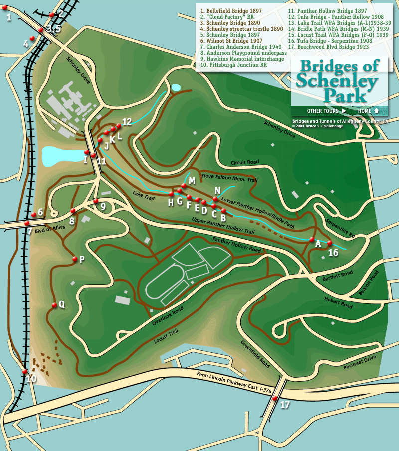

| |
| copyright: © Bruce S. Cridlebaugh 1999-2008 All Rights Reserved | |||