| Home > All By Location regional map > Pittsbugh East > WPA bridges on Bridle Path | |||
|
|
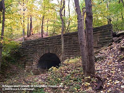
Bridge N More detail photos OFFICIAL NAME: OTHER DESIGNATION: WPA bridges on bridle path (2 structures) LOCATION: Pittsburgh (Schenley Park) USGS 7.5" Topo Quad - UTM Coordinates: Pittsburgh East - Zone 17; 0589 4776 CARRIES: pedestrians, Lower Panther Hollow Bridle Path BETWEEN: -- CROSSES: -- stream TYPE OF CONSTRUCTION / DESIGN: concrete over corrugated steel, stone facing LENGTH OF MAIN SPAN: TOTAL LENGTH (including longest elevated ramp): HEIGHT OF DECK: YEAR ERECTED / ENGINEER: 1939, Works Progress Administration ADDITIONAL INFO: The Panther Hollow Bridle Path curls around the slope of Panther Hollow in a loop of nearly 2.5 miles. The Lower Path gentle falls toward the bottom of the Hollow and links the two Tufa Bridges -- one near each end of the Hollow. Between these two points, two small ravines have been carved by minor tributaries. These gaps are crossed by a pair of faux-arch bridges with stone facing. The construction includes a section of corrugated steel pipe well concealed below the stonework. The Bridle Path bridges were constructed by the WPA in 1939. The Bridle Path is a well-travelled, well-maintained trail, while the Lake Trail lower in elevation and paralleling the Path has been neglected. The Lake Trail has a series of WPA bridges. view page - More information about the WPA bridges on the Lake Trail, plus info about the WPA. FIELD CHECKED: 09-Oct-2000 INFO SOURCES: Submit info or inquiry - share some facts or ask a question. Introduction -- Nearby Structures Page created: Last modified: 14-Nov-2000 |
View Larger Map 

| |
| copyright: © Bruce S. Cridlebaugh 1999-2008 All Rights Reserved | |||