| Home > All By Location regional map > Glassport > Clairton-Glassport Bridge 1928-1987 | |||
|
|
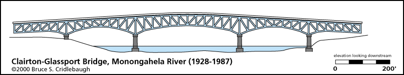
Elevation drawing looking downstream OFFICIAL NAME: OTHER DESIGNATION: Clairton-Glassport Bridge Glassport-Clairton Bridge LOCATION: Clairton - Glassport USGS 7.5" Topo Quad - UTM Coordinates: Glassport - Zone 17; 0594 4462 CARRIED: motor vehicles BETWEEN: -- right descending bank of Monongahela River; Monongahela Av, Glassport -- left descending bank of Monongahela River; State St, Clairton CROSSED: -- Monongahela River at mile 19.3 TYPE OF CONSTRUCTION / DESIGN: Spandrel-braced deck arch (cantilever) trusses on stone piers LENGTH OF MAIN SPAN: TOTAL LENGTH (including longest elevated ramp): 2,562 ft HEIGHT OF DECK: YEAR ERECTED / ENGINEER: 1928, County of Allegheny ADDITIONAL INFO: from the Duquesne Times, September 7, 1928: This structure, connecting the City of Clairton with the Borough of Glassport, was authorized by the people of Allegheny county in the bond issue of April 22, 1924. Construction was started by the board of county commissioners in august 1926. The new bridge is a deck cantilever structure with arched bottom chords similar to Liberty bridge, Pittsburgh. The main bridge structure is 1,534 feet long, consisting of three river spans, totaling 900 feet, and two approach spans, each 317 feet long. At the Clairton end is a deck plate girder viaduct 678 feet long and a reinforced concrete ramp 350 feet long, making the total length of the bridge and approaches 2,562 feet. To obtain a satisfactory connection between State street, Clairton, and the bridge roadway it was necessary to construct an approach ramp 350 long at a five percent grade, paralleling State street. The approach at Glassport end involved major changes as to grades and widths of the Glassport road. The roadway is 21 feet wide between curbs and is surfaced with asphaltic concrete on a concrete base. There are two sidewalks each eight feet wide. Replaced with new structure opened in 1987. The new bridge was built upon the original piers with concrete extensions. FIELD CHECKED: INFO SOURCES: Jim Hartman (www.15122.com/mths) Homestead & Mifflin Township Historical Society Submit info or inquiry - share some facts or ask a question. Introduction -- Nearby Structures Page created: Last modified: 14-May-2004 |
View Larger Map 
| |
| copyright: © Bruce S. Cridlebaugh 1999-2008 All Rights Reserved | |||