| Home > All By Location regional map > Glassport > Pleasant Hills Cloverleaf | |||
|
|
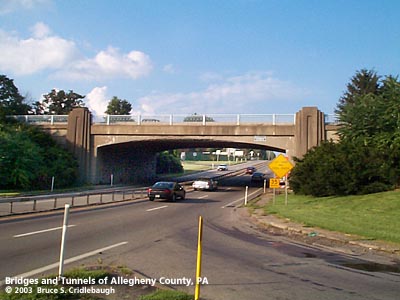
View north on Curry Hollow Road More detail photos OFFICIAL NAME: Pleasant Hills Cloverleaf SR8084 OTHER DESIGNATION: Clairton Blvd over Lebanon Church Rd / Curry Hollow Rd glas587-12 LOCATION: Pleasant Hills USGS 7.5" Topo Quad - UTM Coordinates: Glassport - Zone 17; 0587 4465 CARRIES: Clairton Blvd [PA51] BETWEEN: -- west of intersection with Old Clairton Rd CROSSES: -- Lebanon Church Rd / Curry Hollow Rd [SR2040; Yellow Belt] TYPE OF CONSTRUCTION / DESIGN: Concrete rigid frame LENGTH OF MAIN SPAN: 72 ft TOTAL LENGTH (including longest elevated ramp): HEIGHT OF DECK: YEAR ERECTED / ENGINEER: 1939, Allegheny County ADDITIONAL INFO: from the history page at pleasanthillspa.com: "Originally part of the vast Province of Virginia, what is now our Pleasant Hills was in turn a part of Yohogania County, Westmoreland County, Washington County and finally, in 1788, it became a part of the newly established Allegheny County. The first land owner of record was John Reed, Jr. He named the area Reedsburg and built a log cabin on what is now Orchard Drive. A brother-in-law of his, William Walker, soon followed John and settled on a farm nearby which he named "Pleasant Hill Farm". The stone farm house he built later became a tavern and a stage coach stop. It was located near the Route 51/Lebanon Church Rd Cloverleaf. Today, this home, as well as many other historic local scenes, can be seen in the pictorial history of Pleasant Hills at the Pleasant Hills Public Library." "The first plan of suburban, residential streets and homes actually opened in 1929 along Airport Road -- now known as Lebanon Church Road. Despite the Depression, other developments opened new streets for new home construction. "Suburbia" now included new home owners on Betty Rae Drive, Melvin Drive, Old Lebanon Church Road and Pleasant Hills Boulevard. Local resident, Bill Green had a small refreshment stand on the corner of Old Clairton Road and Route 51 -- which was not much more than a back country road at the time. The new development brought prosperity to the area and soon Bill Green's grew into a famous Pittsburgh Night Club." Lebanon Church and Curry Hollow Roads and the Pleasant Hills Cloverleaf at PA51 were built to help connect the Allegheny County airport (1931) with Pittsburgh, South Park (1928) and the southern suburbs. The Pleasant Hills Cloverleaf is the bow which ties together the several ribbons of 1930s roads. While the locations of older roads were more closely linked to topography, newer roads tend to ignore the lay of the land. Eastward from the town of Large, PA51 ascends the Lewis Run valley toward Pittsburgh. Its earlier route follows Old Clairton Rd along the ridge line (like indian trails would have) south of the valley. The newer multi-lane road, Clairton Blvd (PA51), follows a water level route. Cutting across remnants of the snaking Lewis Run Rd allowed easier grades but required more stream crossings. These small crossings would have been avoided in the old days, but were little trouble when the newer roadway was built between 1929 and 1935. Approaching Century III Mall, PA51 leaves Lewis Run and Lewis Run Rd to climb its own course toward the Cloverleaf. This portion of the road was laid upon part of an old railroad spur -- Pleasant Hills Blvd is the remaining piece of the right-of-way which connected to the Union Railroad. The other roads which meet to intersect at the Pleasant Hills Coverleaf are also newer routings to replace older roads. A small piece of the original Curry Hollow Rd can be found near the Jefferson Memorial Park cemetery. Here the old Baltimore and Ohio Railroad line passes near the 1782 log cabin of Jacob Beam and the 1800 stone and log house of John Work, on the way toward Cochran's Mill and points south. The newer 1930s alignment of Curry Hollow Rd connects South Park to the Cloverleaf with a four-lane ribbon laid across the hills. Similarly, the current Lebanon Church Rd (previously Airport Rd) is a wholly new road which was basically routed like lines drawn on a flat map. The older roads it replaced hide in the valley below the slag dump adjacent to Century III Mall. Period suburban houses line the four-lane Lebanon Church Rd near the Cloverleaf -- indicating a time when traffic volume and speed were much less. Taking its name from the church across the street from the airport, Lebanon Church Rd links the County Airport to the Cloverleaf. The concrete rigid frame span shows a Modern simplicity. The most decorative feature is the thistle railings which were common on projects built by Allegheny County during the time. The same railings were found on Fort Pitt Blvd and Ft Duquesne Blvd and the County's other early interchange: McKnight Rd over Babcock Blvd. The other aesthetic feature is the use of pilasters which flank the span and rise above the sidewalk to form stubby pylons. Metal builder's plaques are mounted on the pylons and walls to the right of traffic approaching from each direction :
FIELD CHECKED: 05-Aug-2003 INFO SOURCES: field check; Pleasant Hills Borough website Submit info or inquiry - share some facts or ask a question. Introduction -- Nearby Structures Page created: Last modified: 16-Oct-2003 |
View Larger Map View Larger Map View Larger Map 
| |
| copyright: © Bruce S. Cridlebaugh 1999-2008 All Rights Reserved | |||