| Home > All By Location regional map > Emsworth > McKnight Rd over Babcock Blvd | |||
|
|
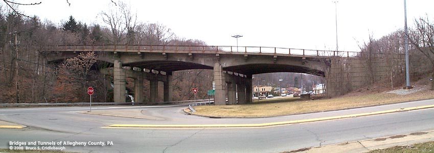
View west: McKnight Rd passes over Babcock Blvd (left) More detail photos OFFICIAL NAME: McKnight Road - Babcock Blvd Interchange Bridge No. 15 Girty's Run OTHER DESIGNATION: McKnight Rd over Babcock Blvd interchange ramps: SR8079 emsw584-8 LOCATION: Ross USGS 7.5" Topo Quad - UTM Coordinates: Emsworth - Zone 17; 0584 4485 CARRIES: McKnight Rd [SR4003, Truck US19] BETWEEN: -- CROSSES: -- Girty's Run; Babcock Blvd [SR4011] TYPE OF CONSTRUCTION / DESIGN: Reinforced haunched concrete beams on concrete bents LENGTH OF MAIN SPAN: 70 ft; 63 ft; 64 ft TOTAL LENGTH (including longest elevated ramp): 221 ft HEIGHT OF DECK: YEAR ERECTED / ENGINEER: 1946, Allegheny County ADDITIONAL INFO: Plaques mounted on pylons at each end of the bridge:
=== The history of the North Hills of suburban Pittsburgh usually begins with the Depreciation Lands. Territory north of the Allegheny River was purchased by the PA General Assembly in 1784 and was offered for sale in 1785 as Depreciation Land to redeem certificates given to Pennsylvania's Revolutionary War soldiers to compensate them for having received pay in depreciated currency. The intersection of McKnight Rd and Babcock Blvd lies almost directly upon one of the survey lines dividing District 3. Numbered west to east, this third district was divided among five men -- Nathaniel Breading, Win. Alexander, Samuel Nicholson, Ephriam Douglass and Samuel Jones -- who would administer the sale of lots of 250 to 300 acres. This part of McKnight Rd very nearly follows the line which defined the eastern limit of the Douglass Survey and the adjoining Jones Survey. The 1906 Hopkins map shows the layout of the roads which today are something like a faint spiderweb beneath many newer roads. Evergreeen Rd was the main road through the area, following the downstream left bank of Girty's Run from Millvale on the Allegheny River. On the hillside above the then southern end of McKnight Rd, the Henry Brooks and his heirs had established a small plan of lots named Brookville; the name survives today only as Brookview Ln. To the west, Cemetery Ln (and its pair of cemeteries) and Rochester Rd (to Rochester in Beaver County) were in place. To the east, Evergreeen Hamlet of 1851 has been recognized as the first suburban housing plan in the United States -- homes which were built away from the city with the intention of a daily commute into the dirty bustle of downtown and a nightly return to a tranquil country neighborhood. Two companies built interurban trolley lines through the North Hills -- each branching off from Pine Creek near Millvale. The Pittsburgh and Butler Street Railway opened its line in 1907, roughly following PA Route 8. Beginning in 1908, the Harmony Short Line (Pittsburgh, Harmony, Butler & New Castle Railway Co.) followed Girty's Run through Ross and McCandless townships as it ventured northward. In 1917, the HSL purchased the Butler Short Line and the merged companies became the Pittsburgh, Mars and Butler Railway. After the PB&M ceased trolley operations in favor of busses, the route of the HSL along Girty's Run was taken over by Allegheny County and rebuilt as Babcock Blvd. Between Seavy Rd, Millvale, and Three Degree Rd, Ross Twp., the old right-of-way has since been straightened, with some older yellow brick sections of the first Babcock Blvd surviving near Millvale. Babcock Blvd. for most of its length was a widening and straightening of separate, but existing, roads through the North Hills. It connects Millvale on the Allegheny River to Valencia in Butler County. Edgar Vose Babcock (1864-1948) made his fortunes in harvesting lumber; the company founded in 1889 and bearing his name is still in operation. He was mayor of Piittsburgh, 1918-20. He was appointed a County Commisioner in the 1925 to replace Addison Gumbert, and elected to the position again in 1927. Following the model of Bigelow in Pittsburgh, Babcock was instrumental in acquiring land for Allegheny County's parks. Recognizing the spread of urban and suburban growth, Babcock purchased large tracts of land at several locations around the county; then sold them to the county at cost for development of parks, beginning with North and South parks. Perhaps not coincidentally, Mr. Bigelow's residence, Vosemary, was located on Babcock Blvd. in Pine Twp. McKnight Rd also appears on the 1906 Hopkins map. Kentzel Rd, now substantially replaced by Seibert Rd, was the main crossroad; it is shown crossing the land of Cath. Kentzel. (B. Seibert is shown on the 1876 map, to the east on Seibert Rd.) To the south in 1906, in the present day location of North Hills Village, lay the land of Leander McKnight and the Margaret McKnight Heirs -- each stretching across the hilltop between McKnight Rd and Evergreen Rd. The 1876 Hopkins map shows their ancestor, Jno. McKnight. Similar to Monroeville in east suburban Pittsburgh, old roads were expanded and replaced -- and traffic and development followed. The geometry of the McKnight Rd - Babcock Blvd interchange indicates that even after the first modernization of McKnight Rd the road retained its southern terminus at Babcock Blvd. With the construction of the interchange and hilltop cut to the south, the four-lane divided roadway was made to connect to the northern end of East St. Previous to this connection in 1946, East St traffic diverted to Evergreen and Peoples Plank Rd to reach Babcock Blvd. The McKnight Rd - East St connection eliminated the need to curl around the hilltops between the heads of various creeks and runs including Nelson Run. Another interchange of similar design was built at McKnight Rd and Nelson Run Rd. The Nelson Run interchange was rebuilt in 2000; its ornamentation and railings were removed and the design was severly altered. It seems the same will happen when the McKnight-Babcock interchange is given its inevitable rehabilitation. Even without the builder's plates which are mounted on pylons at each end of the deck, the "thistle" design of the railings identify this structure as an Allegheny County design. The same railings appear on many other county structures of the time, including Fort Duquesne and Fort Pitt boulevards in downtown Pittsburgh. Unfortunately, as the older bridges are rehabilitated and modernized, the ornamentation is stripped in favor of concrete Jersey barriers. Such is the case with the reconstruction of Fort Pitt Blvd which was built in 1940 and rebuilt in 2002. Reconfigured the previous year, the railings along Fort Duquesne Blvd fared better, perhaps because of its promixity to the Three Sisters bridges. The design of the McKnight-Babcock interchange is Modern and restrained, but includes subtle hints of its time. The edges are rounded and streamlined. The cantilevered brackets which carry the sidewalks are stylized wingtips. Even in heavy concrete, its three spans are open and light enough not to seem a barrier to Babcock Blvd, which up to that time had been the more important road. One span crosses Girty's Run, one crosses Babcock Blvd, and a third crosses an open grassy area which must have seemed park-like to motorists who were as yet unaccustomed to highway interchanges. from the PennDOT Histpric Bridges Survey: "The skewed, 3 span continuous, 221'-long, T beam bridge (70'-63'-64') is supported on concrete abutments with wingwalls and 4 column concrete bents with arched struts. It was built just after WW II when steel prices were very high, and this mandated use of the T beam bridge type. It is nicely detailed with banding on the rounded columns and corbelled brackets at the cantilevered sidewalks that are finished with the standard Allegheny County metal railings. Continuous T beam bridges in the state date to as early as 1913, and it is the earlier examples that represent the technological significance in the application of continuity to the bridge type." FIELD CHECKED: 17-Feb-2000 INFO SOURCES: field check; 1876 and 1906 G.M. Hopkins maps; Joel Fishman, Ph.D. in "Warantee Atlas of Allegheny County, 1914," 2002; 1906 G.M. Hopkins plat map; American Motor Coach Association of PA; Toker, "Pittsburgh: An Urban Portrait;" Western Pennsylvania Conservancy; Allegheny County Parks Dept.; R. Jay Gangewere, "The Story of the Parks" in Carnegie Magazine Submit info or inquiry - share some facts or ask a question. Introduction -- Nearby Structures Page created: Last modified: 01-Aug-2003 |
View Larger Map View Larger Map View Larger Map 
| |
| copyright: © Bruce S. Cridlebaugh 1999-2008 All Rights Reserved | |||