| Home > All By Location regional map > Pittsburgh West > Sixth Street Bridge 1857-1892 | ||||
|
|
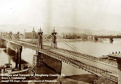
View toward North Side 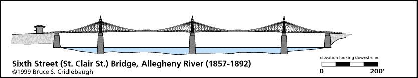
Elevation drawing looking downstream
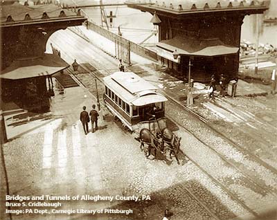
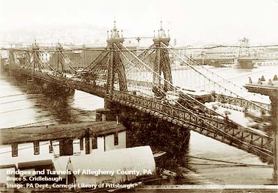
OFFICIAL NAME: OTHER DESIGNATION: Sixth Street Bridge, St. Clair Street Bridge LOCATION: Pittsburgh USGS 7.5" Topo Quad - UTM Coordinates: Pittsburgh West - Zone 17; 0584 4477 CARRIED: pedestrians and horse-drawn vehicles BETWEEN: -- Federal St [Franklin Rd] on right descending bank of Allegheny River -- Sixth St [St. Clair St] on left descending bank of Allegheny River CROSSED: -- Allegheny River at mile 0.5 TYPE OF CONSTRUCTION / DESIGN: wire rope suspension LENGTH OF MAIN SPAN: two main spans, 344 ft; shore spans, 177 ft and 171 ft 20 ft wide roadway, two 8 ft sidewalks TOTAL LENGTH (including longest elevated ramp): 1,036 ft HEIGHT OF DECK: YEAR ERECTED / ENGINEER: 1857-59, John A. Roebling; replaced 1892 ADDITIONAL INFO: Replaced the 1819 covered bridge across the Allegheny River. Designed by John A. Roebling, who had also completed the 1845 Allegheny Aqueduct for the Pennsylvania Canal which crossed the Allegheny River near 11th St, and the 1846 suspension bridge which replaced the burned Monongahela Bridge at Smithfield St. The elevation drawing is simplified to display on screen. Photos indicate twice as many wires and panels. Sixth St was formerly St. Clair St in Pittsburgh; it aligns with Federal St (formerly Franklin Rd which connected to the Venango Path) in the former city of Allegheny (Northside). view page - "Three Sisters" Bridges -- Historic American Engineering Record document FIELD CHECKED: INFO SOURCES: HAER; Lorant, "Pittsburgh"; Smith, "Pittsburgh: Then and Now" Submit info or inquiry - share some facts or ask a question. Introduction -- Nearby Structures Page created: Last modified: 04-Nov-2000 |
View Larger Map 
| ||
| copyright: © Bruce S. Cridlebaugh 1999-2008 All Rights Reserved | ||||