| Home > All By Location regional map > Pittsburgh West > Ninth Street Bridge (Rachel Carson Bridge) | |||
|
|
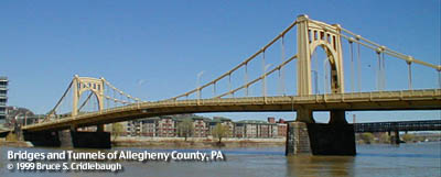
View toward North Side 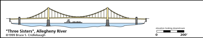
Elevation drawing looking downstream More detail photos OFFICIAL NAME: Rachel Carson Bridge OTHER DESIGNATION: Ninth Street Bridge LOCATION: Pittsburgh USGS 7.5" Topo Quad - UTM Coordinates: Pittsburgh West - Zone 17; 0584 4477 CARRIES: Ninth Street BETWEEN: -- Anderson St on right descending bank of Allegheny River -- Ninth St and Fort Duquesne Blvd on left descending bank of Allegheny River CROSSES: -- Allegheny River at mile 0.7; Tenth Street Bypass TYPE OF CONSTRUCTION / DESIGN: Self-anchored Suspension cables are steel eyebar chain steel eyebar suspenders steel plate girder deck rusticated ashlar piers LENGTH OF MAIN SPAN: 410 ft clear span TOTAL LENGTH (including longest elevated ramp): 995 ft HEIGHT OF DECK: 40.3 ft Emsworth Dam normal pool level 710 ft YEAR ERECTED / ENGINEER: 1925-28, County of Allegheny Vernon R. Covell, T.J. Wilkerson, A.D. Nutter, and H.E. Dodge of the Allegheny County Department of Public Works, engineers; Stanley L. Roush, architect Allegheny County, current owner ADDITIONAL INFO: One of the "Three Sisters." Municipal Art Commission mandated suspension as form of the bridges, but site conditions did not allow for typical anchorages. Bridges were built as cantilevers until catenaries were completed. In a very unusual, self-anchored suspension design, instead of heavy anchorages to hold the cable ends, rigid towers hold the ends apart. First of this type in US. Deck girders were previously painted green and remaining superstructure was painted aluminum grey. Most downtown Pittsburgh river bridges are currently painted golden yellow (the official city colors are Black and Gold). Ninth St was formerly Hand St in Pittsburgh; it aligns with Anderson St in the former city of Allegheny (Northside). Field Notes provide additional technical information. view page - "Three Sisters" Bridges -- Historic American Engineering Record document FIELD CHECKED: 09-Jul-1999 INFO SOURCES: Comm. of PA, et. al.: "Historic Hwy Bridges"; Kidney: "Landmark Architecture"; USACE Allegheny River Nav. Charts Submit info or inquiry - share some facts or ask a question. Introduction -- Nearby Structures Page created: Last modified: 30-Nov-1999 |
View Larger Map View Larger Map View Larger Map 
| |
| copyright: © Bruce S. Cridlebaugh 1999-2008 All Rights Reserved | |||