| Home > All By Location regional map > Pittsburgh West > Ninth Street Covered Bridge 1839-1890 | |||
|
|
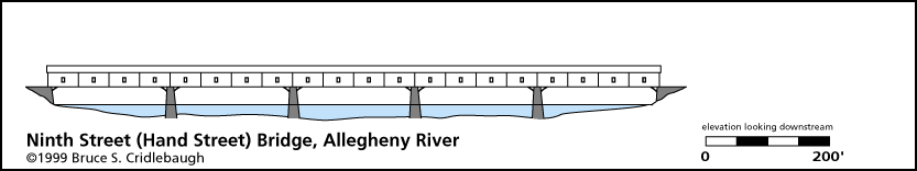
Elevation drawing looking downstream OFFICIAL NAME: OTHER DESIGNATION: Hand Street Bridge Ninth Street Covered Bridge LOCATION: Pittsburgh USGS 7.5" Topo Quad - UTM Coordinates: Pittsburgh West - Zone 17; 0584 4477 CARRIED: pedestrians and horse-drawn vehicles BETWEEN: -- Anderson St on right descending bank of Allegheny River -- Ninth St [Hand St] on left descending bank of Allegheny River CROSSED: -- Allegheny River at mile 0.7 TYPE OF CONSTRUCTION / DESIGN: wooden, Burr arch truss, covered LENGTH OF MAIN SPAN: four spans, 200 ft; one span, 190 ft TOTAL LENGTH (including longest elevated ramp): 990 ft HEIGHT OF DECK: YEAR ERECTED / ENGINEER: 1839, Sylvanus Lothrop, architect; replaced 1890 ADDITIONAL INFO: Third largest Burr arch truss when built. Three lines of arched trusses divided the roadway into two 11 foot widths. The roof of this covered bridge was said to be a "fashionable prommenade." Ninth St was formerly Hand St in Pittsburgh; it aligns with Anderson St in the former city of Allegheny (Northside). The contract was given in January, 1837, to be completed on October 1, 1838. Officers of the Hand Street Bridge Company (Pittsburg and Allegheny Bridge Company) were John Tassey, president, Wm. Larimer, Jr., Charles Avery, Richard Gray, Robert Galway, Sylvanus Lothrop, F. G. Baily, Wm. Robinson, George Ogden, Andrew Leech, and John Grier (managers). Alexander Brackenridge, treasurer. Wm. Fitzsimmons, secretary. Contractors were William Le Barron for the woodwork and Pagan & Allston for the stonework. Lothrop, Le Barron (Labaron) and Pagan are listed in similar capacities for several other bridges of the time, including Northern Liberties (Mechanics) at 16th St and Williamsport at Monongahela City. view page - "Three Sisters" Bridges -- Historic American Engineering Record document FIELD CHECKED: INFO SOURCES: HAER; Lorant, "Pittsburgh"; Smith, "Pittsburgh: Then and Now"; Harris "Pittsburgh business directory...1837" Submit info or inquiry - share some facts or ask a question. Introduction -- Nearby Structures Page created: Last modified: 21-Jun-20001 |
View Larger Map 
| |
| copyright: © Bruce S. Cridlebaugh 1999-2008 All Rights Reserved | |||