| Home > All By Location regional map > Pittsburgh West > Wabash Bridge 1902-1948 | |||
|
|
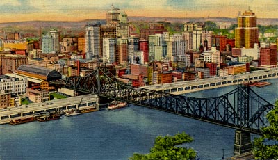
Postcard view 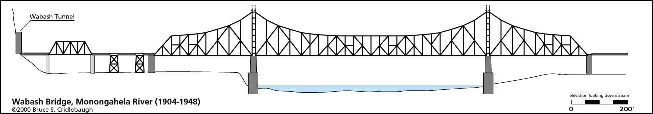
Elevation drawing looking downstream More detail photos OFFICIAL NAME: OTHER DESIGNATION: Wabash Bridge LOCATION: Pittsburgh USGS 7.5" Topo Quad - UTM Coordinates: Pittsburgh West - Zone 17; 0584 4476 CARRIED: Piers only, superstructure removed 1948 Carried Wabash-Pittsburg Terminal Railroad, two tracks BETWEEN: -- right descending bank of Monongahela River at Ferry St (near Stanwix St) -- left descending bank of Monongahela River (between Station Square and Ft Pitt Bridge) CROSSED: -- Monongahela River at mile 0.5 TYPE OF CONSTRUCTION / DESIGN: steel cantilever through truss (removed) piers: rusticated stone LENGTH OF MAIN SPAN: 812 ft clear span TOTAL LENGTH (including longest elevated ramp): 1,504 ft HEIGHT OF DECK: piers (without deck or bearings) rise approx 46 ft above river level YEAR ERECTED / ENGINEER: 1902-04, superstructure removed 1948 Boller and Hodge, engineers George T. Barnsley, architect and supervising engineer ADDITIONAL INFO: Wabash-Pittsburg Terminal Railroad (later the Pittsburgh and West Virginia Railroad) was built by George Jay Gould to compete with the Pennsylvania Railroad, with the expectation that traffic would be generated by Andrew Carnegie's steel plants. Carnegie sold his steel interests to J.P. Morgan as part of the companies which would later combine to form United States Steel. This sale occurred in 1901 -- before the Wabash reached Pittsburgh. The Wabash Bridge collapsed (19-Oct-1903) before it was placed in service. Construction was completed in 1904. City Council passed an ordinance (04-Feb-1904) allowing the Wabash to enter the city. The first train operated out of the Pittsburgh as a special excursion to the World's Fair in St. Louis (04-July-1904). The Terminal and office building opened in 1905, but by 1908 the company was bankrupt. Pittsburgh facilities included Wabash Terminal (an 11-story Beaux-Arts building at Liberty Av and Ferry St [Stanwix St]), the Wabash Tunnel through Mt Washington, a stone skew arch over Saw Mill Run near Woodruff St, and another stone arch which serves as a tunnel for Greentree Rd near Chartiers Creek. The nine-track elevated yard was covered by a trainshed which extended from Forbes Av to Second St (Blvd of Allies) of the southern section of Ferry St (Stanwix St). A switching trestle extended across the Triangle to a location just short of Duquesne Way (Ft Duquesne Blvd). The north leg of the trestle roughly followed the present location of Stanwix St which did not exist at that time. A fire at 410 Liberty Av spread to the trestle and part of the terminal building (06-Mar-1946). A second fire (22-Mar-1946) caused further damage to the terminal building, trainshed and 11 nearby warehouses. This helped clear the way for the construction of Gateway Center during Renaissance I and the site was cleared in 1955. The Wabash Terminal became the site of Gateway 4. The bridge piers have part of many plans for re-use. Skybus, a rubber-tired transit system, was to have entered downtown via a bridge which would have been built atop the existing piers and led to the Wabash Tunnel. The piers have also been decorated with multi-color pennants during festivals, but without maintenance the flags have since been worn away leaving only the array of poles. Recent plans to build a new busway bridge have been discussed, including a basket-handle cable-stayed design. The latest design renderings indicate that the piers would not be used and would likely be removed. While the old piers would aim the bridge deck toward the Westinghouse Building at Stanwix St and Fort Pitt Boulevard, the new bridge would be slightly upstream -- aligned with Stanwix St. view page - Wabash Tunnel under Mt. Washington Pittsburgh Press Roto article, June 5, 1977: view page - "Pittsburgh's Hard-Luck Bridge" by Joe Bennett Additional photos of the Wabash Bridge: view page - Pennsylvania Department, The Carnegie Library of Pittsburgh FIELD CHECKED: INFO SOURCES: Kobus and Consoli, "The Pennsy in The Steel City" and "The Pennsylvania Railroad's Golden Triangle"; Lorant: "Pittsburgh: The Story of an American City"; Smith, "Pittsburgh: Then and Now"; Pittsbrgh Gazette Times, "Story of Pittsburgh and vicinity", 1908 Submit info or inquiry - share some facts or ask a question. Introduction -- Nearby Structures Page created: Last modified: 29-Aug-2001 |
View Larger Map View Larger Map 
| |
| copyright: © Bruce S. Cridlebaugh 1999-2008 All Rights Reserved | |||