| Home > All By Location regional map > Pittsburgh West > Monongahela Bridge 1818-1845 | |||
|
|
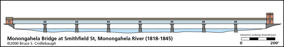
Elevation drawing looking downstream OFFICIAL NAME: Monongahela Bridge OTHER DESIGNATION: LOCATION: Pittsburgh USGS 7.5" Topo Quad - UTM Coordinates: Pittsburgh West - Zone 17; 0584 4476 CARRIED: Smithfield Street Pedestrian walkways on upstream and downstream sides BETWEEN: -- Water St -- Carson St (West Carson and East Carson split is marked at this intersection.) CROSSED: -- Monongahela River at mile 0.7 -- Monongahela Wharf TYPE OF CONSTRUCTION / DESIGN: Burr arch truss - covered (see HAER article for details) LENGTH OF MAIN SPAN: 8 spans, 188 ft each TOTAL LENGTH (including longest elevated ramp): 1,500 ft between abutments HEIGHT OF DECK: 37 ft est YEAR ERECTED / ENGINEER: 1818; Lewis Wernwag, engineer burned in Fire of 1845; replaced 1845-46 ADDITIONAL INFO: The current structure is the third bridge on this site. Lewis Wernwag built the covered wooden Monongahela Bridge in 1818, the first river crossing bridge in Pittsburgh. It replaced a ferry and cost $102,000. It was destroyed in the Great Fire of 1845 and replaced the following year. John Roebling, creator of the Brooklyn Bridge, designed a wire rope suspension bridge which used the 6 piers and abutments from the earlier bridge (8 spans, 188 ft each). Roebling's first highway bridge operated as a toll bridge. Increasing live loads from added traffic resulted in excessive deflections and swaying, leading to its closure and replacement with current structure. view page -- Historic American Engineering Record (PA-2) article. FIELD CHECKED: INFO SOURCES: Historic American Engineering Record (PA-2) Submit info or inquiry - share some facts or ask a question. Introduction -- Nearby Structures Page created: Last modified: 05-Oct-2000 |
View Larger Map 
| |
| copyright: © Bruce S. Cridlebaugh 1999-2008 All Rights Reserved | |||