| Home > All By Location regional map > Pittsburgh West > Fort Pitt Bridge | |||
|
|
View north from Station Square parking lot 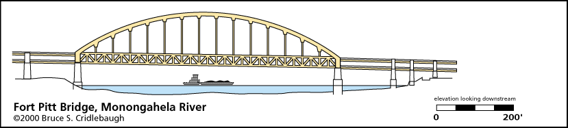
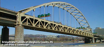
Elevation drawing looking downstream More detail photos OFFICIAL NAME: Fort Pitt Bridge OTHER DESIGNATION: Parkway West #1, Parkway West #8 LOCATION: Pittsburgh USGS 7.5" Topo Quad - UTM Coordinates: Pittsburgh West - Zone 17; 0583 4476 CARRIES: Interstate 279, US22, US30 [Penn Lincoln Parkway West] - northbound on upper deck (US22/30 East), southbound on lower deck (US22/30 West) - four lanes wide; pedestrian walkway on downstream side of lower deck southwestern ramps connect: to/from I-279 via Fort Pitt Tunnels, PA837-East Carson St northeastern ramps connect: to/from I-279 via Portal Bridge, Liberty Av, I-376 Penn-Lincoln Parkway to 10th St Bypass via Portal Bridge, Blvd of Allies BETWEEN: -- near Point State Park on right descending bank of Monongahela River -- Fort Pitt Tunnels and local ramps on left descending bank of Monongahela River CROSSES: (RDB to LDB) Monongahela River at mile 0.2; CSX RR (P&LE); East Carson St [PA837]; NS RR (Conrail) TYPE OF CONSTRUCTION / DESIGN: steel bowstring arch; double-deck arch is riveted plates cross-bracing on arch is warren truss made of oval-perforated beams suspenders are wire cable deck is riveted plates in warren truss piers are faced with dressed stone LENGTH OF MAIN SPAN: 750 ft (640 ft horizontal clearance in nav channel) TOTAL LENGTH (including longest elevated ramp): 1207/1217 ft est HEIGHT OF DECK: 47.1 ft at northern pier Emsworth Dam normal pool level 710 ft YEAR ERECTED / ENGINEER: 1956-1959 (opened June 19, 1959), PA Dept of Highways George S. Richardson, engineer PennDOT, current owner ADDITIONAL INFO: Near visual twin of nearby Ft. Duquesne Bridge, although the main Fort Pitt span is almost 200 feet longer. Opened for traffic 15 1/2 months before Fort Pitt Tunnels were opened. Famous as the "best way to enter an American city," motorists travelling from the West on I-279 are given no visual cues regarding their nearness to downtown Pittsburgh as they enter the Fort Pitt Tunnels. Emerging from the portal, the Golden Triangle suddenly bursts into view framed by the yellow crossbracing of the bridge's arch. view page - Related info from the Portal Bridge in Point State Park FIELD CHECKED: INFO SOURCES: USACE Monongahela River Nav. Charts; Lorant: "Pittsburgh: The Story of an American City" Submit info or inquiry - share some facts or ask a question. Introduction -- Nearby Structures Page created: Last modified: 26-Apr-2002 |
View Larger Map View Larger Map View Larger Map View Larger Map View Larger Map 
| |
| copyright: © Bruce S. Cridlebaugh 1999-2008 All Rights Reserved | |||