| Home > All By Location regional map > Pittsburgh West > West End Bypass over Saw Mill Run | |||
|
|
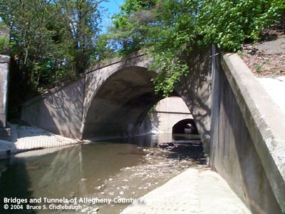
View east (downstream) with Dumas St culvert beyond More detail photos OFFICIAL NAME: OTHER DESIGNATION: West End Bypass over Saw Mill Run LOCATION: Pittsburgh USGS 7.5" Topo Quad - UTM Coordinates: Pittsburgh West - Zone 17; 0582 4477 CARRIES: West End Bypass [US19, PA51] southbound Saw Mill Run Blvd BETWEEN: -- south of Steuben St -- north of South Main St [PA60] CROSSES: -- Saw MIll Run TYPE OF CONSTRUCTION / DESIGN: Filled spandrel concrete arch (culvert) LENGTH OF MAIN SPAN: 64 ft TOTAL LENGTH (including longest elevated ramp): HEIGHT OF DECK: YEAR ERECTED / ENGINEER: 1950, PA Dept of Highways ADDITIONAL INFO: from the PennDOT Historic Bridges survey: The culvert carries a 2 lane street with shoulders over a stream in Pittsburgh's West End, near the intersection of SR 51 and SR 837. The West End Bypass was built in 1950 as an extension of Saw Mill Run Blvd. Some 20 years earlier the Allegheny County Public Works Department had completed major projects on either side of the West End Valley -- Saw Mill Run Blvd in 1928 and the West End Bridge in 1932 -- but there was no easy connection between them. Traffic was routed over the relatively narrow city streets of the West End (aka Temperanceville): Woodville Rd and Independence St, formerly Washington Pike. Further up Saw Mill Run, the valley split into two main branches at Shalersville; the western branch, named Banksville Run, was accompanied by Banksville Rd and the Banksville (coal) Railroad. The eastern branch held the main stream of Saw Mill Run -- its Little Saw Mill Run Railroad was acquired by the Wabash Pittsburg Terminal Railroad (later West Side Belt Railroad, etc, now Wheeling and Lake Erie) whose large metal trestles remain a noteable feature in the valley. The roadway following Saw Mill Run south from Shalersville was Woodville, Woodstock, and Woodruff streets -- cutoff "oxbows" of these are still evident. With the completion of the Liberty Tunnel further south in 1924, the valley received an increase in traffic and was also seen as a possible location for a "modern" highway. In 1920's terms, this would be a wider roadway of more than one lane in each direction. A 1928 bond issue provided for the construction of four such boulevards in Allegheny County: Saw Mill Run Blvd, Ohio River Blvd, Allegheny River Blvd (each of which received special landscaping and entrance pylons with carved scenes from local history) and Mosside Blvd. Saw Mill Run Blvd began at the conjunction of Clairton Blvd [PA51] and Library Rd [PA88]. (Clairton Blvd extends deep into the southwestern part of the county including the area's first "modern" interchange at the crossroads which linked to South Park and the County Airport.) The new boulevard continued northward along its namesake stream to the intersection with Banksville Rd ending at Banksville Circle -- a traffic circle which was once at the current location of the Parkway West just outside the Ft Pitt Tunnel. With the construction of the Penn Lincoln Parkway, completed in 1953, the disjointed pieces were linked via the West End Bypass which would also offer an alternate route around the Fort Pitt Tunnel for Parkway traffic. Such was the case during the tunnel's reconstruction in 1999-2000 and the Bypass was reconstructed and widened in anticipation. With the reconfiguration of the West End Circle (2000-2008), the 3 span, 1950 structure over South Main Street in the West End will be replaced with a new bridge slightly to the west. view page - Other structures in the West End Valley FIELD CHECKED: 10-May-2004 INFO SOURCES: field check Submit info or inquiry - share some facts or ask a question. Introduction -- Nearby Structures Page created: Last modified: 13-Jul-2004 |
View Larger Map 
| |
| copyright: © Bruce S. Cridlebaugh 1999-2008 All Rights Reserved | |||