| Home > All By Location regional map > Pittsburgh West > Termon Av Approach over Verner Av | |||
|
|
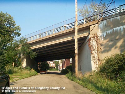
View northeast on Verner Av More detail photos OFFICIAL NAME: OTHER DESIGNATION: Termon Av Approach over Verner Av LOCATION: Pittsburgh USGS 7.5" Topo Quad - UTM Coordinates: Pittsburgh West - Zone 17; 0581 4480 CARRIES: Termon Avenue Approach BETWEEN: -- Callifornia Av at Termon Avenue -- Ohio River Blvd CROSSES: -- Verner Av TYPE OF CONSTRUCTION / DESIGN: Deck precast prestressed concrete beam LENGTH OF MAIN SPAN: 75 ft TOTAL LENGTH (including longest elevated ramp): 75 ft HEIGHT OF DECK: YEAR ERECTED / ENGINEER: 1930, Allegheny County Rebuilt 1971, City of Pittsburgh ADDITIONAL INFO: The Termon Avenue Approach was built in conjunction with Ohio River Blvd and the McKees Rocks Bridge to connect with California Avenue which had been the main route between Pittsburgh and the Northern Boroughs along the Ohio River. The Approach meets California Av at Termon Av -- the latter being in place for decades before the new connecting road borrowed its name. Termon Av Approach crosses Verner Av which once extended all the way to the flat land along the Ohio River. There are remnants of the old route below the Ohio River Blvd bridge. Verner Av descended along a cliff ledge to a viaduct to cross the multi-tracked Ft Wayne Division of the Pennsylvania Railroad. Termon Av Approach is one of the few places where the original brick pavers used in the County's Ohio River Blvd project may still be seen. This bridge over Verner Av has lost its ties to the original 1930 design since being replaced in 1971. Yet the roadway nearer the Boulevard and the McKees Rocks Bridge gives the best example of the historical appearance the County's prototypical boulevards -- including the stairway, retaining wall and cast railings near Granada St. FIELD CHECKED: 17-Aug-2004 INFO SOURCES: field check Submit info or inquiry - share some facts or ask a question. Introduction -- Nearby Structures Page created: Last modified: 25-Oct-2004 |
View Larger Map View Larger Map View Larger Map 
| |
| copyright: © Bruce S. Cridlebaugh 1999-2008 All Rights Reserved | |||