| Home > All By Location regional map > Pittsburgh West > Ohio River Boulevard over Woods Run and Eckert St | |||
|
|
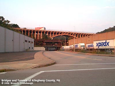
View east on Eckert St from Beaver Av More detail photos OFFICIAL NAME: OTHER DESIGNATION: Ohio River Boulevard over Woods Run and Eckert St LOCATION: Pittsburgh USGS 7.5" Topo Quad - UTM Coordinates: Pittsburgh West - Zone 17; 0581 4480 CARRIES: Ohio River Boulevard [PA65] BETWEEN: -- Bainton St -- Forsythe St CROSSES: -- Woods Run (covered) -- Eckert St TYPE OF CONSTRUCTION / DESIGN: Deck open spandrel concrete arch LENGTH OF MAIN SPAN: 250 ft est TOTAL LENGTH (including longest elevated ramp): 510 ft HEIGHT OF DECK: 100 ft est YEAR ERECTED / ENGINEER: 1930, Allegheny County ADDITIONAL INFO: FIELD CHECKED: 17-Aug-2004 INFO SOURCES: field check Submit info or inquiry - share some facts or ask a question. Introduction -- Nearby Structures Page created: Last modified: 14-Oct-2004 |
View Larger Map View Larger Map View Larger Map 
| |
| copyright: © Bruce S. Cridlebaugh 1999-2008 All Rights Reserved | |||