| Home > All By Location regional map > Pittsburgh West > PC&Y RR Fleming Park Bridge | |||
|
|
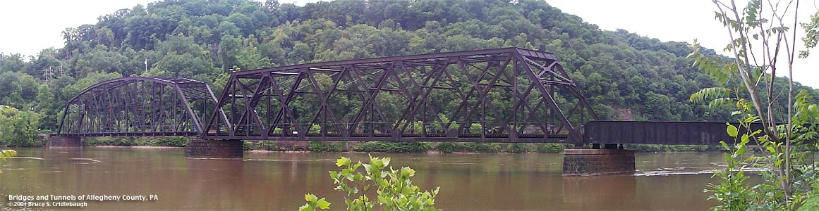
View downstream from Neville Island More detail photos OFFICIAL NAME: OTHER DESIGNATION: PC&Y RR Fleming Park Bridge pghw577-2 LOCATION: Neville Twp - Stowe Twp USGS 7.5" Topo Quad - UTM Coordinates: Pittsburgh West - Zone 17; 0577 4482 CARRIES: Pittsburgh Industrial Railroad [Pittsburgh, Chartiers and Youghiogheny RR], single track BETWEEN: -- Neville Rd (Neville Island) -- Old Fleming Park Rd, Island Av [PA51] CROSSES: -- Ohio River back channel at Mile 5.4 -- CSX RR TYPE OF CONSTRUCTION / DESIGN: Pennsylvania-Petit Pratt through truss; subdivided Double Warren through truss; two deck girder spans LENGTH OF MAIN SPAN: 280 ft est TOTAL LENGTH (including longest elevated ramp): 920 ft est (includes 100 ft causeway) HEIGHT OF DECK: 7 ft est Emsworth Dam normal pool level 710 ft YEAR ERECTED / ENGINEER: ADDITIONAL INFO: The older photo shows the original configuration of this bridge. The bridge in the foreground is the 1894 Fleming Park Bridge. The two trusses on the island side of the PCY RR bridge have since been replaced by deck girder spans. The Whipple truss center span was also replaced by a Pratt truss with fewer panels. The photo was taken before the 1921 Emsworth Dam would have raised the river pool level...and the ice in the river shows the low water level. The river level is much higher now -- covering about half the exposed height of the PCY RR piers. The vertical clearance below the trusses appears to be about 7 feet. The Ohio River back channel is about 590 feet wide. Because the bridge crosses at an angle of approximately 40 degrees, the over-water length of the bridge is about 850 feet. An earthen causeway extends about 100 feet into the channel from the Fleming Park river bank. Estimated lengths of the spans (from Fleming Park to Neville Island): 30ft deck girder span; 280ft camelback Pennsylvania-Petit Pratt through truss; stone pier; 260ft subdivided double Warren through truss; stone pier; 140ft pony girder; stone pier; 140ft pony girder. The single track railroad enters a concrete underpass below Neville Rd. The Pittsburgh Industrial Railroad was sold to the Ohio Central RR which now operates this line as the Pittsburgh and Ohio Central RR (POHC). FIELD CHECKED: 29-May-2001 INFO SOURCES: USACE Ohio River Nav. Charts; field check Submit info or inquiry - share some facts or ask a question. Introduction -- Nearby Structures Page created: Last modified: 30-May-2001 |
View Larger Map View Larger Map 
| |
| copyright: © Bruce S. Cridlebaugh 1999-2008 All Rights Reserved | |||