| Home > All By Location regional map > Pittsburgh West > Fleming Park Bridge | |||
|
|
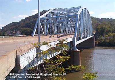
View south from Neville Island 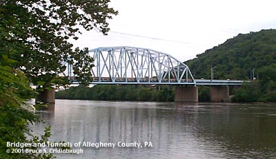
View upstream from Neville Island OFFICIAL NAME: Fleming Park Bridge Allegheny County Bridge No. 4 Ohio River Back Channel OB04 OTHER DESIGNATION: Fleming Park Neville Island Bridge pghw577-2 LOCATION: Neville Twp - Stowe Twp USGS 7.5" Topo Quad - UTM Coordinates: Pittsburgh West - Zone 17; 0577 4482 CARRIES: Neville Rd, Fleming Park Rd; four lanes divided sidewalk on upstream side BETWEEN: -- Neville Rd (Neville Island) -- Old Fleming Park Rd, Island Av [PA51] CROSSES: -- Ohio River back channel at Mile 5.3 -- PC&Y RR [CSX RR] TYPE OF CONSTRUCTION / DESIGN: steel camelback Warren through truss; deck girders LENGTH OF MAIN SPAN: 390ft est TOTAL LENGTH (including longest elevated ramp): 953ft est. HEIGHT OF DECK: Emsworth Dam normal pool level 710 ft YEAR ERECTED / ENGINEER: 1955, County of Allegheny ADDITIONAL INFO: Mounted on the railing on the upstream side, a plaque reads:
The shape of the bearing plates of the previous bridge are visible in the abutment on the Neville Island end of the current bridge. This bridge replaced an 1894 through truss bridge which was one of two built to allow a streetcar connection between Coraopolis (Middletown) and Pittsburgh via Neville Island (Montour Island). The old bridge had three truss spans with flat top chords. Estimated lengths of the spans (from Fleming Park to Neville Island): 155ft deck girder over 3 tracks of CSX RR; concrete pier at river bank; 155ft deck girder span [33ft of this span is a cantilevered continuation of the beam forming the first span, the remaining 122ft is suspended by a hinge at the south end and bearing on the pier at the north end]; concrete pier; 390ft subdivided Warren through truss main span; 155ft deck girder simple span; concrete pier at Neville river bank; 33ft deck girder simple span. The Ohio River back channel is about 590 feet wide. Because the bridge crosses at an angle which creates a 65 degree skew, the over-water length of the bridge is about 660 feet. Built in 1955, the bridge was updated with Jersey barriers in 1988. FIELD CHECKED: 29-May-2001 INFO SOURCES: USACE Ohio River Nav. Charts; field check Submit info or inquiry - share some facts or ask a question. Introduction -- Nearby Structures Page created: Last modified: 30-May-2001 |
View Larger Map View Larger Map 
| |
| copyright: © Bruce S. Cridlebaugh 1999-2008 All Rights Reserved | |||