| Home > All By Location regional map > Pittsburgh West > Fleming Park Bridge 1894 | |||
|
|
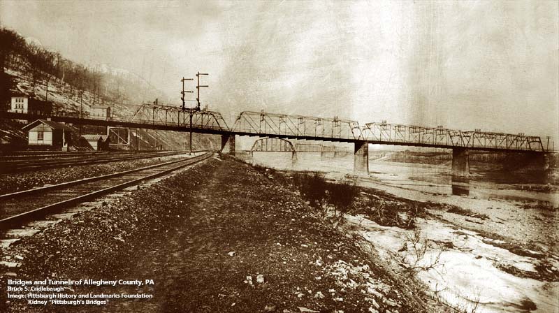
View from Fleming Park with Neville Island at right and PCY RR bridge in background 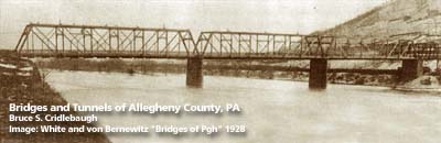
View upstream from Neville Island 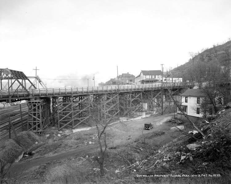
Temporary wooden bridge in 1947 OFFICIAL NAME: OTHER DESIGNATION: Fleming Park Neville Island Bridge pghw577-2 LOCATION: Neville Twp - Stowe Twp USGS 7.5" Topo Quad - UTM Coordinates: Pittsburgh West - Zone 17; 0577 4482 CARRIED: Neville Rd, Fleming Park Rd BETWEEN: -- Neville Rd (Neville Island) -- Old Fleming Park Rd, Island Av [PA51] CROSSED: -- Ohio River back channel at Mile 5.3 -- PC&Y RR [CSX RR] TYPE OF CONSTRUCTION / DESIGN: Pratt through truss, 3 equal spans, 1 shorter truss over RR; deck girder approach spans LENGTH OF MAIN SPAN: TOTAL LENGTH (including longest elevated ramp): HEIGHT OF DECK: YEAR ERECTED / ENGINEER: 1894 (1885?) Temporary wooden bridge built adjacent, Department of the Navy: 1942-1955 Replaced 1955 ADDITIONAL INFO: This structure was one of two built to allow a streetcar connection between Coraopolis (Middletown) and Pittsburgh via Neville Island (Montour Island). The shape of the bearing plates of this bridge are visible in the abutment on the Neville Island end of the current bridge. The top photo shows the bridge before the 1921 Emsworth Dam controlled the pool level of the Ohio River. The river level is much higher now -- covering about half the exposed height of the PCY RR piers. The truss configuration of the PCY RR bridge was changed after this photo. At Cole Av, named for George Cole who subdivided part of his land here, a filled arch shows the location of the underpass which once led under Old Fleming Park Rd [current PA51]. The arch crossed Shane Hollow Run and a coal railroad that ascended the valley to the south. The Fleming Park bridge in the 1947 photo is a temporary wooden bridge built in 1942 to accommodate heavy war-time traffic to the Dravo shipyards on Neville Island. As early as 1935, the county was advertising for bid to rehab the original structure built for the street railway company. It was closed for two weeks after damage during the 1936 St Patricks Day Flood. Some sources noted that first bridge as 1894, but a 1950 newspaper article says it was 65 years old (1885). By 1947 the wooden bridge was needing repairs, the Navy and the County were in constant debate over who had responsibility. The County gave the bridge back to the Navy and made plans for a new bridge which opened in 1955. FIELD CHECKED: INFO SOURCES: Maurey, Edward B. "Where the West began; a story of Coraopolis and the Ohio Valley." Coraopolis, PA : Record Pub. Co. 1930. Submit info or inquiry - share some facts or ask a question. Introduction -- Nearby Structures Page created: 16-Nov-2000 Last modified: 14-Oct-2009 |
View Larger Map 
| |
| copyright: © Bruce S. Cridlebaugh 1999-2008 All Rights Reserved | |||