| Home > All By Location regional map > Pittsbugh East > Brinton Rd over Parkway East | |||
|
|
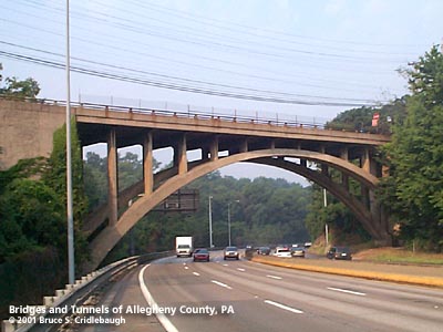
View westbound from I-376 More detail photos OFFICIAL NAME: Brinton Rd Bridge OTHER DESIGNATION: LOCATION: Braddock Hills - Edgewood USGS 7.5" Topo Quad - UTM Coordinates: Pittsburgh East - Zone 17; 0595 4474 CARRIES: -- Brinton Rd [SR2051] BETWEEN: -- Maple Av, Township Rd, Brinton Rd, McKelvey Rd (Edgewood) -- McKelvey Rd (Braddock Hills) CROSSES: -- Parkway East [I-376, US22, US30], five lanes divided (three lanes eastbound) (station 1020+00) TYPE OF CONSTRUCTION / DESIGN: open spandrel, reinforced concrete deck arch LENGTH OF MAIN SPAN: 164 ft TOTAL LENGTH (including longest elevated ramp): HEIGHT OF DECK: 60 ft clearance YEAR ERECTED / ENGINEER: 1948, PA Dept of Highways ADDITIONAL INFO: The Brinton Rd Bridge has the look of the Allegheny County Department of Public Works which had been using and reusing similar designs during the 1930s and 1940s. Although this bridge looks like it could have been built as part of Ohio River Blvd, records show it to be built for the state. As such it follows the pattern along the Parkway East that there were no patterns -- no standard types. In this case, a 200-foot gap between hilltops called for a single span and the result is the second of two concrete arch bridges on the Parkway East; the other uses three arches to carry the highway over Nine Mile Run at Commericial St. This bridge was built by the Sanctis Construction Company of Pittsburgh. Construction took place from October, 1947, to December, 1948. The highway grading in this section was not started until January, 1950, apparently needing to await the completion of the complex of structures in Edgewood Borough including the railroad overpass and the Brinton Av bridge. In the late 1940s, Brinton Rd (then SR2103) was a rural road. Edgewood was for many years the edge of the developed suburbs of Pittsburgh. The original roads here were Township Rd, now partially rerouted as Brinton Rd, and McKelvey Rd, named for the family who once owned most of the Braddock Twp valley extending toward Ardmore Blvd. The bridge moved Brinton Rd to the west. To align with the southern part of the old Brinton Rd with Maple Av in Edgewood, the deck of this bridge has a horizontal curve of about 10 degrees. An eastbound climbing lane begins just past the Chestnut St overpass and continues up the 5 percent grade under the Brinton Rd Bridge. The lane was added after the original highway was completed, but fortunately the 164-foot span allowed barely enough clearance. The arch abutments are very close to the narrow shoulders. The 1904 G. M. Hopkins plat map shows the NY&CGC Co railroad operating a spur line from the PRR mainline along what would become the Parkway route to the east. This line extended to the location of the Brinton Rd bridge. Another plate from the map book shows the spur served the Enterprise Brick and Stone Co, which included an incline plane from Chalmers St in Swissvale and a mine (also with an incline plane) which pierced the hillside on McKelvey property to the north of the current Parkway route. FIELD CHECKED: 02-Aug-2001 INFO SOURCES: field check; 1953 PA Dept of Highways report; Hopkins maps Submit info or inquiry - share some facts or ask a question. Introduction -- Nearby Structures Page created: Last modified: 07-Aug-2001 |
View Larger Map View Larger Map View Larger Map 
| |
| copyright: © Bruce S. Cridlebaugh 1999-2008 All Rights Reserved | |||