| Home > All By Location regional map > Pittsbugh East > Lincoln Rd over Shades Run | |||
|
|
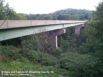
View west (upstream right) More detail photos OFFICIAL NAME: OTHER DESIGNATION: Lincoln Rd over Shades Run pghe594-6 LOCATION: Penn Hills USGS 7.5" Topo Quad - UTM Coordinates: Pittsburgh East - Zone 17; 0594 4480 CARRIES: Lincoln Rd BETWEEN: -- west of Lincoln Avenue Ext, Doak St and Fahey St -- Riverview Memorial Cemetery (formerly Sunset View) CROSSES: -- Shades Run TYPE OF CONSTRUCTION / DESIGN: Welded steel I-beam on concrete hammerhead piers LENGTH OF MAIN SPAN: 200 ft est TOTAL LENGTH (including longest elevated ramp): 399 ft HEIGHT OF DECK: YEAR ERECTED / ENGINEER: 1987, Allegheny County ADDITIONAL INFO: On site, remnants of the previous bridge are elusive. Based on various maps, it appears there may have been two previous spans. Jas. Shades appears on the 1872 and 1876 Hopkins maps above the western branch of the Shades Run ravine. The surrounding property is shown as having been purchased by William Coleman with his partner Frank Rahm owning land on the opposite, eastern side. The name Coleman and Rahm Co is shown. An inclined plane railroad ran along what seems to be the present day line of Verona Place. The incline carried coal from coal mines at the head of the valley down to the Allegheny Valley Railroad, later acquired as the Brilliant Branch of the Pennsylvania Railroad. At the bottom of the valley, Waring Station was renamed Coleman Station; there are remains of a branch railroad spur turning up the Shades Run valley, and a concrete viaduct was part of the 1930 Allegheny Valley Blvd. Surrounding the upper reaches of the two-pronged Shades Run valley, Coleman and Rahm were joined by Shoenberger (owner of a prominent iron works in Pittsburgh's Strip), John Fitzsimmons and J. W. Doak (the latter two have local roads named for them). A biography of Coleman and his industrial interests would be too long to fit here, but he figures in the establishment of the Allegheny Valley Railroad, the New York and Cleveland Gas Coal Company (an combination of coal mining operations throughout eastern Allegheny County which included Andrew Carnegie), an iron rail factory, real estate speculation, and the second ranked investor in the 1873 establishment of Carnegie, McCandless & Company's Edgar Thomson Steel Works -- the beginning of U.S. Steel. Pucketty Road, the Indian name derived from the creek which forms Allegheny County's northeastern border, was changed to Lincoln Avenue after the 1865 death of the President. The old road connected Pittsburgh to towns along the Kiskiminetas River to the east. Prior to c1905 the old road followed a more southerly route to avoid Shades Run: Verona Blvd, Mt Carmel Rd, Tyler Rd, returning to Lincoln Rd. Earlier Hopkins maps show Lincoln Av ending at Shades Run with a streetcar loop. The 1907 USGS map implies a bridge over Shades Run on an alignment similar to, if not slightly north of, the 1987 span. Curiously, the 1995 USGS aerial photo (taken after the current bridge was built) seems to show a depression in the southwestern part of the River View Cemetery; the depression aligns with the stub end of Lincoln Avenue Extension. At first it seems the two pieces could have been directly linked by a bridge, but the topography doesn't seem to have made this a logical choice -- it's a wider spot than places immediately adjacent. Yet, comparing this with the 1907 map, it seems that the two were possibly linked by a curving addition on each road with the bridge crossing just to the south -- between the sewage treatment plant and the 1987 bridge. Typically, a bridge in such a rural location c1907 would have either been built by the street railway company under speculation or by the County to link the city with outlying areas. The former does not appear likely since even today the edge of dense residential build-up ends abruptly at Shades Run; even the Hopkins maps into the 1930s show an unsettled, ever-changing, and (compared to what was built) quite inaccurate series of road and lot configurations. It is more likely that the County would have built a bridge here, and today Lincoln Road is a County maintained road and bridge. Without looking at County records, it's not certain what the first crossing might have been here. But assuming a c1905 bridge would not have been substantial enough to survive heavier traffic loads, and the public works boom around the Great Depression and World War II, it seems likely the 1987 bridge replaced a structure from that time. FIELD CHECKED: 05-Jul-2004 INFO SOURCES: field check; Hopkins plat maps (1872, 1876, 1886, 1903, 1939); 1907 USGS topo quad; Braddock History Committee, "Unwritten History of Braddock's Field"; Durant, "History of Allegheny County," 1876 Submit info or inquiry - share some facts or ask a question. Introduction -- Nearby Structures Page created: Last modified: 07-Jul-2004 |
View Larger Map View Larger Map 
| |
| copyright: © Bruce S. Cridlebaugh 1999-2008 All Rights Reserved | |||