| Home > All By Location regional map > Pittsbugh East > Rankin Bridge | |||
|
|
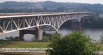
View south (upstream left) Elevation drawing looking downstream OFFICIAL NAME: George Rankin Jr. Memorial Bridge OTHER DESIGNATION: Rankin Bridge Allegheny County Bridge Number 7, Monongahela River pghe595-16 LOCATION: Whitaker - Rankin - Braddock USGS 7.5" Topo Quad - UTM Coordinates: Pittsburgh East - Zone 17; 0594 4473 CARRIES: Green Belt; motor vehicles, four lanes sidewalks on each side BETWEEN: -- Braddock Av intersecting with Kenmawr Av (Rankin and Braddock) on right descending bank of Monongahela River -- River Blvd (Whitaker) and Kennywood Blvd [PA837, Green Belt] on left descending bank of Monongahela River CROSSES: -- Monongahela River at mile 9.6 TYPE OF CONSTRUCTION / DESIGN: Steel cantilever spandrel-braced deck arch LENGTH OF MAIN SPAN: 505.25 ft TOTAL LENGTH (including longest elevated ramp): HEIGHT OF DECK: 45.0 ft, vertical clearance, at left spring line of channel span 75.0 ft, vertical clearance, at center line of channel span Emsworth Dam normal pool level 710 ft YEAR ERECTED / ENGINEER: 1951, County of Allegheny ADDITIONAL INFO: FIELD CHECKED: 10-May-2000 INFO SOURCES: USACE Monongahela River Nav. Charts Submit info or inquiry - share some facts or ask a question. Introduction -- Nearby Structures Page created: Last modified: 05-Dec-2000 |
View Larger Map View Larger Map View Larger Map 
| |
| copyright: © Bruce S. Cridlebaugh 1999-2008 All Rights Reserved | |||