| Home > All By Location regional map > Pittsbugh East > Braddock Bridge 1897 | ||||
|
|
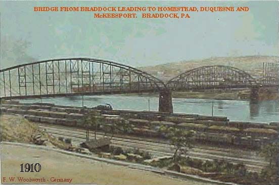
1910 postcard
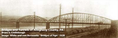
OFFICIAL NAME: OTHER DESIGNATION: Braddock Bridge West Braddock Bridge LOCATION: Whitaker - Rankin - Braddock USGS 7.5" Topo Quad - UTM Coordinates: Pittsburgh East - Zone 17; 0593 4473 CARRIED: motor vehicles, two lanes Monongahela street railway BETWEEN: -- Braddock Av at Talbot Av (Rankin and Braddock) on right descending bank of Monongahela River -- River Blvd (Whitaker) Old Braddock Rd [Kennywood Blvd] on left descending bank of Monongahela River CROSSED: -- (RDB to LDB) Monongahela River at mile 9.6; Union RR; Pittsburgh, Virginia & Charleston RR [PRR, Conrail, NSRR] TYPE OF CONSTRUCTION / DESIGN: steel through truss, wooden plank deck LENGTH OF MAIN SPAN: TOTAL LENGTH (including longest elevated ramp): 3 spans ? HEIGHT OF DECK: YEAR ERECTED / ENGINEER: 1897 ADDITIONAL INFO: Replaced by George Rankin Jr. Bridge in 1951. The Braddock Bridge was constructed in 1897 in part as a connection for the Monongahela Street Railway. Andrew Mellon financed the trolley line which connected Homestead and Duquesne; at the south end of the bridge, the North View Plan and Mellon Plan of houses are shown on plat maps of 1900. The Monongahela Street Railway acquired the holdings of the Braddock Electric line which had been started in 1893 as Braddock's second electrified line. The first was the Braddock and Turtle Creek Railway Company of 1891 -- which began with two converted horse cars and was later extended from Homestead [via Highland Station and Brown's Bridge] to Wilmerding as the Second Avenue Passenger Company. The first car of the MSRwy operated over the West Braddock Bridge on July 5, 1897. In Braddock, the Yellow Line operated on Talbot Av as far as Thirteenth St. The company paid Braddock council $5000 for a franchise to build a bridge over the Monongahela River below Kennywood Park as a means of connecting to Duquesne and points up river. Charles Kenny [Kenney] purchased land on the bluff opposite the Monongahela River from Braddock in 1818 for the purpose of mining coal. Andrew Mellon invested $25,000 to create a trolley park at Kenny's Grove in Mifflin Twp. The grove grew into the present day Kennywood amusement park. To the surprise of Braddock council, the Mellons constructed their main line past Kennywood -- abandonning the plans for a second bridge over the Mon. The first car operated between Braddock and Duquesne passed over the West Braddock Bridge, December 10, 1898. The Blue Line was opened to connect to Rankin when the approach to the West Braddock Bridge was lengthened over the B&O RR tracks in 1901. The Monongahela Street Railway Company was consolidated [with Consolidated Traction and United Traction] into Pittsburgh Railways Company January 1, 1902. The PRC was ultimately acquired by the Port Authority. FIELD CHECKED: INFO SOURCES: White & von Bernewitz "Bridge of Pittsburgh"; Lamb, ed. "The Unwritten History of Braddock's Field"; Beal "McKeesport Trolleys" Submit info or inquiry - share some facts or ask a question. Introduction -- Nearby Structures Page created: Last modified: 16-Jan-2001 |
View Larger Map 
| ||
| copyright: © Bruce S. Cridlebaugh 1999-2008 All Rights Reserved | ||||