| Home > All By Location regional map > Pittsbugh East > Lincoln Av over Washington Blvd | |||
|
|
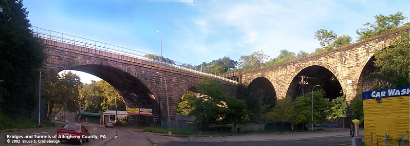
Lincoln Av (left) crosses above Washington Blvd and through Brilliant Cutoff Viaduct (right) More detail photos OFFICIAL NAME: OTHER DESIGNATION: Lincoln Av Bridge over Washington Blvd LOCATION: Pittsburgh USGS 7.5" Topo Quad - UTM Coordinates: Pittsburgh East - Zone 17; 0592 4479 CARRIES: -- Lincoln Av BETWEEN: -- Renfrew St -- Atwell St CROSSES: -- Washington Blvd [PA8, Blue Belt] -- site of Silver Lake TYPE OF CONSTRUCTION / DESIGN: stone arch [2 arch spans] LENGTH OF MAIN SPAN: 120 ft [2 equal arch spans] TOTAL LENGTH (including longest elevated ramp): 430 ft est 48 ft wide HEIGHT OF DECK: 60 ft est YEAR ERECTED / ENGINEER: 1905-1906, City of Pittsburgh ADDITIONAL INFO: The 1872 and 1904 Hopkins maps show the property around Silver Lake as belonging to George Finley. On the south shore of the lake, where the PRR viaduct now crosses, stood "Lake Home." The valley to the west carried Spring Run which was joined by a mineral spring in feeding Silver Lake. Silver Lake was noted as a favored ice skating location; the site was a common postcard image, especially after the building of the stone arches. A few roads managed to connect east and west near the southern head of the Negley Run Valley. Frankstown Rd and Penn Av, remaining traces of the British military roads, made the easiest course. Pucketty Road, the Indian name derived from the creek which formed part of Allegheny County's eastern border, ventured down one side and up the other in making the connection between East Liberty and towns on the Kiskimenetas River farther to the east. Not long after the death of the President, Pucketty Road was renamed in memoriam to Abraham Lincoln. An 1875 Hopkins map shows Fifth Av extending as far north as Lincoln Av in an apparent intersection. But at that time Butler St (the lower part of the current Washington Blvd) and Fifth Av did not connect. Butler St followed the current Negley Run Blvd to East Liberty. Pittsburgh City Council passed an ordinance to open Washington Blvd between Fifth Av and Highland Park on July 15, 1895. The 1904 Hopkins map shows the completed roadway in the valley, named Beechwood Avenue. Between Fifth Av and the Allegheny River, the roadway was renamed Washington Blvd and was part of an 11-1/2 mile drive which included Grant (now Bigelow), Beechwood and Washington Blvds in a promenade connecting downtown with Pittsburgh Director of Public Works Edward Manning Bigelow's two new parks (1889): Schenley and Highland. It seems Lincoln Av once crossed the Negley Run valley on a lesser bridge. After the PRR constructed its landmark Roman viaduct in 1903, the city of Pittsburgh replaced the Lincoln Av bridge with its own stone viaduct of two spans. Though the PRR project was part of a larger plan to upgrade its lines with more permanent structures, it seems the city made an effort to encourage the parklike setting of the boulevard and surrounding valley. Sources note the Lincoln Av stone structure as 1905; the keystone reads 1908. The PRR accomodated the avenue by crossing above with a steel span. In time, however, Silver Lake was filled in and converted to a drive-in movie theater. The theater was replaced by a set of industrial buildings. Any trace of a parklike ambiance is gone -- Washington Blvd is lined with a haphazard jumble of concrete block commericial buildings jammed in the narrow valley floor. Barely wide enough to be marked for four lanes, traffic blazes through at nearly double the speed limit. === view page - PRR Brilliant Cutoff stone arch viaduct view page - Larimer Avenue Bridge over Washington Blvd FIELD CHECKED: 31-Aug-2002 INFO SOURCES: field check; G. M. Hopkins maps; Kidney, "Pittsburgh's Bridges" Submit info or inquiry - share some facts or ask a question. Introduction -- Nearby Structures Page created: Last modified: 10-Sep-2002 |
View Larger Map View Larger Map View Larger Map 
| |
| copyright: © Bruce S. Cridlebaugh 1999-2008 All Rights Reserved | |||