| Home > All By Location regional map > Pittsbugh East > Parkway East Int - Squirrel Hill / Homestead | |||
|
|
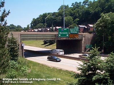
Ramp AD over Parkway East mainline More detail photos OFFICIAL NAME: Penn Lincoln Parkway East - Interchange 8 - Squirrel Hill / Homestead [mileage-based interchange # 5] Forward Av Interchange SR8008 OTHER DESIGNATION: LOCATION: Pittsburgh USGS 7.5" Topo Quad - UTM Coordinates: Pittsburgh East - Zone 17; 0590 4475 CARRIES: -- eastbound entrance to Parkway East [I-376, US22, US30] from Beechwood Blvd -- eastbound exit from Parkway East [I-376, US22, US30] to Beechwood Blvd and Forward Av [Ramp E] -- westbound entrance to Parkway East [I-376, US22, US30] from Forward Av -- westbound entrance to Parkway East [I-376, US22, US30] from Beechwood Blvd and Forward Av [Ramp AD] -- westbound exit from Parkway East [I-376, US22, US30] to Beechwood Blvd and Forward Av [Ramp AD] BETWEEN: CROSSES: -- Ramp AD: crosses mainline of Parkway, carrying westbound exit and westbound entrance to and from Beechwood Blvd and Forward Av -- Ramp E: crosses Ramp G at Greenfield exit, carrying eastbound exit to Beechwood Blvd and Forward Av -- Forward Av over Ramp G [westbound Beechwood Blvd] TYPE OF CONSTRUCTION / DESIGN: -- Ramp AD: steel riveted plate girder simple span on concrete abutments -- Ramp E: steel girder stringers simple span on concrete abutments -- Forward Av over Ramp G [westbound Beechwood Blvd]: reinforced concrete rigid frame LENGTH OF MAIN SPAN: -- Ramp AD: 86 ft, 3 in; 47 ft width -- Ramp E: 42 ft TOTAL LENGTH (including longest elevated ramp): HEIGHT OF DECK: YEAR ERECTED / ENGINEER: 1952, PA Dept of Highways ADDITIONAL INFO: The arm of the Four Mile Run valley which once held Saline St was substantially filled in to allow an even grade at the western portal of the Squirrel Hill Tunnel. Fills up to 35 deep were used to create a grade of 4 percent to 5 percent west of the tunnel entrance. But the bulk of the material excavated from the tunnel was deposited to a depth of 1,000 feet at the eastern portal; the tunnel was blasted from east to west. Four bridges and two-and-a-half miles of ramps for this interchange stretch out over a 3,000 ft arc to fit into the valley between Squirrel Hill and Greenfield. But for all the efforts to conform the highway to the space, the most infamous ramp on the Parkway East descends from Beechwood Blvd. The steep ramp carries all entering eastbound traffic from the surrounding area. From a stop sign at the base of the ramp, vehicles cross the eastbound exit ramp (exit only), then make their way into the Parkway mainline -- just over a thousand feet from the entrance to the Squirrel Hill Tunnel. The combination of crossing traffic, three lanes choking to two, and the apparent claustrophobia some drivers feel from the tunnel make this area the prime cause of evening rush hour jams. The most visible bridge in the interchange is Ramp AD. It carries ramp traffic, one lane in each direction between concrete barriers akin to a bobsled track, between Beechwood Blvd and the westbound Parkway. The span is unique along the Parkway East for its riveted plate girder beams -- a busy assemblage of seemingly tiny pieces. Though other bridges built at the same time elsewhere along this highway used fewer and larger pieces, this 86-foot crossing seems more similar to bridges 20 years older. Also unusual about this structure is that the entire span is carried by those riveted plate girder beams; typical beam bridges along the Parkway East include several parallel beams (stringers) which stretch the length of the span between bearing points. On Ramp AD, only the two main girders span the 86 feet; a series of smaller beams are placed transversely with yet smaller beams in place to complete a grid to support the deck. Below grade, "concrete cylinders forty-two feet to sixty-two feet in depth, to support the abutments, were carried through the fill to rock foundation," according to a 1953 PA Dept of Highways report. Another span carries traffic exiting from the eastbound Parkway. Allowing access to Greenfield, a small radius ramp peels off of Ramp E as it crosses Ramp G. Because the ramp splits above the crossing, two sets of beams intersect creating a small but complicated floor plan. Several of the beams have a haunched (curved) lower flange to allow higher clearance. Ramp E then continues on toward Squirrel Hill and Homestead. The third span in this interchange carries a relocated Forward Av over Ramp G at the intersection with Beechwood Blvd. This bridge shows yet another type: reinforced concrete rigid frame. The parapets do not match indicating that the bridge may have been widened. The eastern parapet features a survey benchmark and a Pennsylvania Department of Highway keystone embedded in concrete with a coarse aggregate. The western parapet is similar to a modern Jersey barrier. Two main roads in this valley were affected by the construction of this interchange in 1952. Forward Av was diverted to end at Beechwood Blvd. Saline St was cut into two sections: the lower section dead ends in Four Mile Run valley near the Beechwood Blvd Bridge; the upper section emerges below the Murray Av bridge and continues to the top of Brown's Hill, where it once led to the salt works at the outflow of Nine Mile Run into the Monongahela River. The homes which line Beechwood Blvd facing the interchange appear to be all from the exact same plan and built before the highway in 1928. Twenty homes were removed to make way for the ramps and relocated roadways. FIELD CHECKED: INFO SOURCES: PA Dept of Highways, "Penn Lincoln Parkway", 1953 Submit info or inquiry - share some facts or ask a question. Introduction -- Nearby Structures Page created: Last modified: 19-Jul-2001 |
View Larger Map View Larger Map 
| |
| copyright: © Bruce S. Cridlebaugh 1999-2008 All Rights Reserved | |||