| Home > All By Location regional map > Pittsburgh East > Sharpsburg Bridge 1856-c1900 | |||
|
|
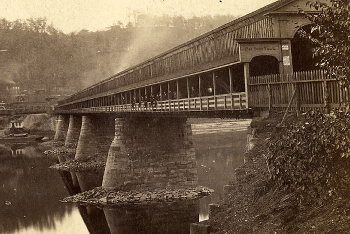
1856 bridge (downstream right) OFFICIAL NAME: OTHER DESIGNATION: Sharpsburg Bridge LOCATION: Pittsburgh - Etna USGS 7.5" Topo Quad - UTM Coordinates: Pittsburgh East - Zone 17; 0589 4482 CARRIES: vehicles BETWEEN: -- Bridge St (Etna) on right descending bank of Allegheny River -- Butler St (Pittsburgh) on left descending bank of Allegheny River CROSSES: -- (north to south) Allegheny River at mile 5.4 TYPE OF CONSTRUCTION / DESIGN: Wooden covered bridge LENGTH OF MAIN SPAN: TOTAL LENGTH (including longest elevated ramp): HEIGHT OF DECK: YEAR ERECTED / ENGINEER: 1856 ADDITIONAL INFO: A bridge is shown at this location on maps as old as 1876. The Belgian block section of Bridge St hugs the downstream side of the current bridge, crosses the railroad track and ends at the remnants of the abutment with concrete steps to the downstream side. This area is shown in the photo. Under one of the concrete bents of the current bridge there is a collection of rough hewn stones which may have been part of the old piers. 62nd Street is the last numbered street in a grid which began at the Point in Pittsburgh and extends along the Allegheny River through the Strip District and Lawrenceville (Arsenal). Read more about the numbered streets in the notes about Pittsburgh Street Names. Older Belgian block streets curve around and under either side of the southern entrance to the bridge from Butler St. The older bridges were built at a lower deck height and these streets presumably led to the older spans. Replaced c1900 by metal through truss Sharpsburg Bridge. FIELD CHECKED: INFO SOURCES: Ken Kobus, Purviance photo Submit info or inquiry - share some facts or ask a question. Introduction -- Nearby Structures Page created: Last modified: 22-Dec-2008 |
View Larger Map 
| |
| copyright: © Bruce S. Cridlebaugh 1999-2008 All Rights Reserved | |||