| Home > All By Location regional map > Pittsbugh East > Schenley - Junction Hollow street railway trestle | |||
|
|
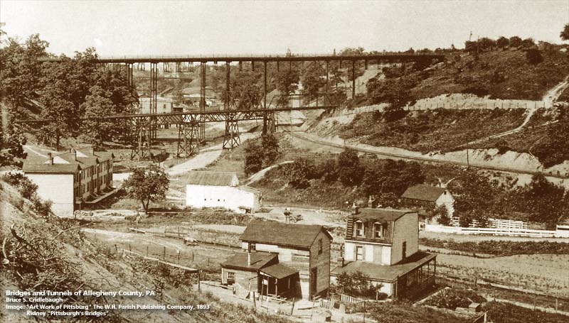
View northward in Junction Hollow showing temporary 1890 Schenley Bridge trestle with street railway trestle in foreground OFFICIAL NAME: OTHER DESIGNATION: Junction Hollow trestle Schenley street railway trestle LOCATION: Pittsburgh (Oakland - Schenley Park) USGS 7.5" Topo Quad - UTM Coordinates: Pittsburgh East - Zone 17; 0589 4477 CARRIED: Squirrel Hill Railroad Co. street railway BETWEEN: -- CROSSED: -- Boundary St (Neville St); Pittsburgh Junction RR [B&O RR]; Four Mile Run; Joncaire St TYPE OF CONSTRUCTION / DESIGN: LENGTH OF MAIN SPAN: TOTAL LENGTH (including longest elevated ramp): HEIGHT OF DECK: YEAR ERECTED / ENGINEER: c1889 ADDITIONAL INFO: Chartered in October 1887, the Squirrel Hill Railroad Company was to be an approximately 3.5 mile route from Fifth Av and Boquet St, through the future site of Forbes Field, over Junction Hollow, through the future site of Carnegie-Mellon University and into Squirrel Hill via Homewood Av, Murray Av and to a point near Homewood Cemetery at Beechwood Blvd and Dallas Av. Work was begun by McKibbon & Co in mid-1889. Further contracts were issues to Martin G. Frank for woodwork on bridges, F. Melber for bridge piers and masonry, and the Johnson Company for rails, spikes and fixtures. With construction complete over nearly half of the route, City Parks Director, Edward Bigelow disputed whether street railways should be permitted to pass through public parks -- in the case, the newly forming Schenley Park. Although Mary Schenley had given right-of-way to the railway company for $1, Bigelow having recently accepted the 300 acre Schenley parcel for the new park, contested the route in court. While litigation began, the city public works department tore up the line within the park boundaries. The battle caused shareholders to withhold their funds, which in turn, led to non-payment to the contractors and more lawsuits. Work was stopped in Febraury 1890 and the assets sold at Sheriff's Sale. Though a couple of photos show the line in operation, Hopkins plat maps offer no evidence of its existence. The 1886 map was a couple years too early; and by the 1904 edition, all traces are gone. Surrounding the location of the Junction Hollow trestle, Carnegie Institute of Technology (Carnegie-Mellon University) planning was underway by 1904 (Hopkins shows the land owned then by Christopher Magee and the city) and Forbes Field would be opened in 1909. The trestle was roughly parallel to the north of Joncaire St on the western side of the Hollow. The structure passed over the intersection of Joncaire and Neville streets where they converged with the Pittsburgh Junction Railroad, the B&O railroad company. The street railway passed over the steam railroad via a through truss, while the rest of the structure was a series of deck trusses on trussed bents. Joncaire St is shown on the older maps as continuing up the eastern slope of Junction Hollow, where the Squirrel Hill rail line was roughly parallel to its south. Joncaire was vacated and erased with the construction of the first buildings of the University campus Porter Hall (Industries Hall) in 1905. FIELD CHECKED: INFO SOURCES: "Pittsburgh Railways, Vol. 1," Ronald L. Beal; Hopkins plat maps; "Pittsburgh's Landmark Architecture," PHLF Submit info or inquiry - share some facts or ask a question. Introduction -- Nearby Structures Page created: Last modified: 17-Jun-2004 |
View Larger Map 
| |
| copyright: © Bruce S. Cridlebaugh 1999-2008 All Rights Reserved | |||