| Home > All By Location regional map > Pittsbugh East > Washington Crossing Bridge at 40th St | ||||||||||||||||||||||||||||||||||||||||||||||||||||
|
|
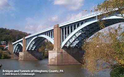
Downstream left 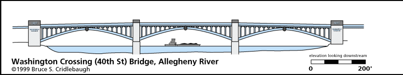
Elevation drawing looking downstream More detail photos OFFICIAL NAME: Washington Crossing Bridge OTHER DESIGNATION: 40th Street Bridge pghe587-13 LOCATION: Pittsburgh - Millvale Borough USGS 7.5" Topo Quad - UTM Coordinates: Pittsburgh East - Zone 17; 0587 4480 CARRIES: 40th St (SR2124) 3 lanes undivided - motor vehicles pedestrian sidewalk on both upstream and downstream sides of deck BETWEEN: -- PA28 [Alexander H. Lindsay Memorial Highway, East Ohio St] near Feilbach St (Millvale) on right descending bank of Allegheny River -- 40th St, intersecting Foster St (Pittsburgh), on left descending bank of Allegheny River CROSSES: -- (RDB to LDB) 2 northbound bypass lanes of PA28 [East Ohio St, Alexander H. Lindsay Highway]; Conrail (NS) Conemaugh Division - 3 tracks; CSX (BO) access to 33rd St railroad bridge at Herr's Island (Washington's Landing) and former BO RR Willow Grove Yard; North Shore bike/hike trail access (incomplete); Millvale Borough public works storage yard; Allegheny River at mile 3.2; south shore bike/hike trail access and parking; abandoned railroad 1-3 tracks formerly entrance to PRR 38th St Yard; County of Allegheny Bridge Maintenance 40th St Warehouse at Willow St TYPE OF CONSTRUCTION / DESIGN: Steel deck arch - riveted plate girder; 3 main spans; 3-hinged; open spandrel; 4 ribs Approach spans: steel plate girder simple spans (9 at north approach, 3 at south approach, plus 1 steel plate girder span added as grade separation project) Concrete piers, abutments and approach span bents Granite portal railings and obelisks LENGTH OF MAIN SPAN: 360 ft each (350 ft clear) TOTAL LENGTH (including longest elevated ramp): 2,366 ft [2630 ft including abutment ramps, estimated as follows: north abutment approach 187 ft; simple spans (1-9) 90, 90, 90, 90, 90, 120, 105, 120; north arch pier 48; north arch (between piers) 315; north channel pier 28; channel arch 315 (between piers); south channel pier 28; south arch (between piers) 315; south arch pier 48; simple spans (13-15) 105, 120, 90; former end bent 5; grade separation simple span and south abutment approach 60.] HEIGHT OF DECK: 72.5 ft low steel clearance at spring line of arches 180 ft clearance at center of arch Emsworth Dam normal pool level 710 ft YEAR ERECTED / ENGINEER: 1919-1924 ($2,344,904) County of Allegheny James G. Chalfant, County Engineer 1919-1922 Vernon R. Covell, County Engineer 1922-1924 Benno Janssen, Janssen & Cocken, Architect Charles Stratton Davis, Associate Engineer PennDOT, current owner ADDITIONAL INFO: The entrances to the bridge feature dressed ashlar walls curving outward from the road. At each end of the ballustrade, one of four obelisks stand as entry pylons. Below the southwest and northeast obelisks, a plaque reads: Also mounted on the wall below the southwest obelisk, a plaque reads:
Mounted below the southeast and northwest obelisks a plaque reads:
The steel superstructure is constructed of riveted plate girders. The three main spans are open spandrel 3-hinged arches having 4 ribs. All metal parts of the bridge are painted light blue. The center hinge of each arch is hidden behind a cartouche measuring approximately 15 ft high by 15 ft wide decorated with what appears to be the seals of Allegheny County and Pennsylvania. These cartouches, six in number and painted black, are not visible from the bridge. They are also difficult to see from shore and are best viewed from the river. The approach spans are a series of simple spans using 4 stringers each. The 1939 modifications made for grade separation involved opening a section of the south abutment and adding 5 stringers to support the deck. This allows 2 northbound lanes of PA28 to bypass the intersection with the bridge. A rusticated stone retaining wall was also added to allowing the widening of PA28 and support Feilbach St. Identical plaques mounted on each side of the grade separation underpass read:
The concrete bents bearing the approach spans have 4 columns with arches under the cap. The arch abutment piers which stand on each shore rise some 30 feet higher than the deck. On the outside surface are mounted large copper letters including the date which contradicts the opening date and the crossing anniversary date: WASHINGTON CROSSING 1923 At each side of the center arch, the tops of the piers provide a widened section of sidewalk which act a viewing platforms, each about 28 ft in length. The ballustrade which runs the length of the bridge includes metal reliefs of the Great Seal of each of the 13 original United States plus the County of Allegheny. Each measures approximately 2 ft wide by 3 ft high. They appear in the following order (north to south): Allegheny County, New Hampshire, Massachusetts, Rhode Island, Connecticut, New York, New Jersey, Pennsylvania, Delaware, Maryland, Virginia, North Carolina, South Carolina, Georgia. This order is roughly the same order as the states appear in the map from north to south, with Allegheny County providing a divider to restart the series. The series repeats just over 10 times per side with a total of 290 seals on the bridge. Photos There was a design competition but the sculptor's name is unknown. The models were created by John Donnelly and Company, New York City; the castings were made by the Michaels Art Bronze Company, Covington, KY. The railing is painted light blue, but the seals were painted in full color by volunteers under the guidance of Stan Hubenstein of Shaler, PA, in 1976. (A Post-Gazette source refers to "Stan Hubstenberger of Shaler.") Jersey barriers separate the traffic lanes from the sidewalk. There is a Pennsylvania Department of Transportation Survey Control Mark on the jersey barrier at the southeast corner of the bridge. Also notch and paint benchmarks are located on two corners of the stone entrance walls, one at each end of the bridge. Stencil lettering outside of the first north approach span reads: 5+72 8-82 This may indicate the date (August 1982) of the current 3-lane concrete deck surface, jersey barriers, and lane control signals. Original lighting fixtures were attached to poles mounted outside the railings; the mounts are still visible. Cyclone fences line both sides of the north approach spans above the railroad. As representatives of the colony of Virginia, Washington and Gist were returning from a meeting the the French General St. Pierre near Erie, PA in the winter of 1753. They arrived at the Allegheny near Sharpsburg to find the river only partially frozen over and not passible on foot. After spending the night camped on the north (downstream right) bank, they built a raft and attempted the crossing at sunset. Impeded by ice, Washington was soon thrown into the freezing river and forced to make for a nearby island, Wainwright's or Garrison. The island has since become part of the south (downstream left) shore. The Washington Crossing Bridge was opened on the 171st anniversary of the event, December 29,1924. A 1923 newspaper article describes Washington and Gist crossing the river. The Delaware Indian village Shannapin's Town was located at 40th St between Butler St and the river. A State Historical Commision sign stands at the south entrance to the bridge. The sign reads: Also mounted on the wall below the southwest obelisk, a plaque reads:
A wooden covered bridge previously crossed at 43rd St (Ewalt St) from 43rd St Station to Millvale Station. At that time, 43rd Street was a major street of Lawrenceville. Now it appears as a very narrow residential street. view page - Washington Crossing Bridge -- 40th Street over the Allegheny River (HAER PA-447), Dr. David S. Rotenstein, et al, 1997 / Pennsylvania Historic Bridges Recording Project - I. FIELD CHECKED: 15-Jun-1999 INFO SOURCES: USACE Allegheny River Nav. Charts; Kobus and Consoli, "The Pennsy in The Steel City," Gay and Evert: "Discovering Pittsburgh's Sculpture" Submit info or inquiry - share some facts or ask a question. Introduction -- Nearby Structures Page created: Last modified: 10-Oct-2000 |
View Larger Map View Larger Map 
| ||||||||||||||||||||||||||||||||||||||||||||||||||
| copyright: © Bruce S. Cridlebaugh 1999-2008 All Rights Reserved | ||||||||||||||||||||||||||||||||||||||||||||||||||||