| Home > All By Location regional map > Pittsbugh East > Parkway East and B&O RR over Maurice St | |||
|
|
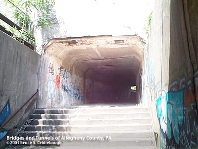
View north from beneath B&O RR span of Parkway overpass More detail photos OFFICIAL NAME: OTHER DESIGNATION: Penn Lincoln Parkway East over stairway at Maurice St LOCATION: Pittsburgh USGS 7.5" Topo Quad - UTM Coordinates: Pittsburgh East - Zone 17; 0587 4476 CARRIES: -- Parkway East [I-376, US22, US30] -- former B&O RR right-of-way [Eliza Furnace trail] BETWEEN: -- Second Av east of Brady St, near Union Switch and Signal parking garage -- public stairway at Maurice St (connects to Forbes Av near Lawn St) CROSSES: -- pedestrian underpass for steps at Maurice St TYPE OF CONSTRUCTION / DESIGN: concrete box LENGTH OF MAIN SPAN: TOTAL LENGTH (including longest elevated ramp): HEIGHT OF DECK: YEAR ERECTED / ENGINEER: Parkway structures: c1952, PA Dept of Highways B&O RR: c1900 ?; modified c1930 ? ADDITIONAL INFO: The street which descended the hillside below Forbes Av to Second Av (then Braddock St) was originally named Murphy St. After the city of Pittsburgh annexed surrounding municipalities in 1868, many street names were changed throughout the city. Murphy St was changed to Maurice St. The street was so steep that old maps show it with steps accompanying it along its eastern curb. The 1872 and 1904 Hopkins maps indicate that Maurice St was fully connected to Second Av -- providing access to the Jones and Laughlin steel works on the Monongahela River from the Soho neighborhood above. The old maps show the ravine which is now nearly filled and grown over was once a densely built group of homes with Copper Works Station on the Pittsburgh and Connellsville RR, two churches and a bridge spanning the head of the valley between Forbes Av and Lawn St. The grade separation projects of Forbes Av and Blvd of the Allies (c1930) seem to have permanently cut off the southern portion of Maurice St to vehicles. Pedestrians must have continued to use this route in sufficient numbers into the 1950s. When the Penn Lincoln Parkway was constructed, it was deemed important enough to include this underpass. The steel mills were still quite active at that time. The newer section of the pedestrian underpass is crossed by six highway lanes. A former B&O RR bridge (now carrying the Eliza Furnace Recreational Trail) is the most visible part of this pair of structures. The stonework on the retaining wall which forms the eastern abutment appears to be from the early 1900s. The western abutment is concrete and seems to indicate that without the need for an underpass wide enough for vehicles, the rebuilt span was shortened. Other bridges on this B&O line were rebuilt in the early 1930s (B&O RR over Second Av at Greenfield Av); presumably this span would have been rebuilt at that time. The metal girder railroad bridge over Brady St may offer an idea of the original bridge at Maurice St. The opening was fenced closed in May 2006. FIELD CHECKED: 14-May-2001 INFO SOURCES: G.H. Hopkins maps Submit info or inquiry - share some facts or ask a question. Introduction -- Nearby Structures Page created: Last modified: 14-Jun-2006 |
View Larger Map View Larger Map 
| |
| copyright: © Bruce S. Cridlebaugh 1999-2008 All Rights Reserved | |||