| Home > All By Location regional map > Pittsbugh East > South Side Works Tunnel - P&LE RR | |||
|
|
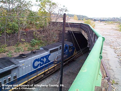
Eastern portal at South 29th St More detail photos OFFICIAL NAME: OTHER DESIGNATION: South Side Works Tunnel LOCATION: Pittsburgh USGS 7.5" Topo Quad - UTM Coordinates: Pittsburgh East - Zone 17; 0587 4475 CARRIES: CSX [Pittsburgh & Lake Erie RR] BETWEEN: -- Hot Metal St [South 29th St] -- South 25th St UNDER: site of LTV South Side Works former Jones & Laughlin Steel, American Iron Works TYPE OF CONSTRUCTION / DESIGN: cut and cover; cut stone side walls steel beam ceiling TOTAL LENGTH: 2,038 ft est 392 ft partially enclosed east of 29th St; 1,646 ft fully enclosed between S. 29th St and S. 25th St OTHER DIMENSIONS: 30 ft est wide YEAR OPENED / ENGINEER: ADDITIONAL INFO: Passes under the 110 acre site of the former LTV South Side Works. The area was cleared of the industrial structures from the steel works and is being redeveloped by the Urban Redevelopment Authority with residential, office, retail and recreational construction. The Pittsburgh, Virginia & Charleston RR was built through the former borough of Ormsby. That line ran down the middle of Larkins Ay. An industrial track of the PVC RR ran on the alley at South 29th St and curved around the Jones & Laughlin American Iron Works. The section near the Works is nearly identical in location to the current tunnel, but the 1872 Hopkins map does not indicate that the line was underground at that time. The PVC RR was acquired by the Pennsylvania Railroad. The PRR -- later Conrail, then Norfolk Southern -- was established away from the riverfront between Mary and Josephine streets. The railroad running through the South Side Works Tunnel was formerly the Pittsburgh & Lake Erie -- now part of CSX. The P&LE was placed in operation from the J&L South Side Works to Youngstown, OH in 1879. East of the South Side Works, the P&LE acquired the Pittsburgh, McKeesport & Youghiogheny RR to extend the road to the south and east via the Western Maryland RR. Under the strictest definition, this is not a tunnel. A trench was excavated, side walls constructed, and simple steel beams laid across the top. There appears to be a minimal amount of fill above. There are indications that the structure was modified and extended many times. Some sections have massive cut stone wall, while other sections use poured concrete walls. Toward the eastern end, sections are covered with open steel grating. FIELD CHECKED: INFO SOURCES: Submit info or inquiry - share some facts or ask a question. Introduction -- Nearby Structures Page created: Last modified: 25-Jul-2001 |
View Larger Map 
| |
| copyright: © Bruce S. Cridlebaugh 1999-2008 All Rights Reserved | |||