| Home > All By Location regional map > Pittsbugh East > Baltimore and Ohio Bridge at 33rd St | |||
|
|
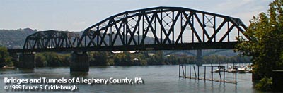
Main channel span of Allegheny River (view downstream from Herrs Island) 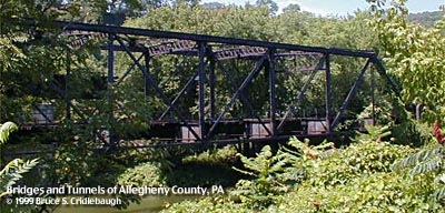
Back channel span (view downstream from Herrs Island) 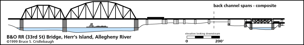

Elevation drawings looking downstream OFFICIAL NAME: OTHER DESIGNATION: B&O Railroad Bridge at 33rd Street and Herr's Island pghe586-18 channel span; pghe586-12 back ch downstream; pghe586-13 back ch upstream LOCATION: Pittsburgh USGS 7.5" Topo Quad - UTM Coordinates: Pittsburgh East - Zone 17; 0586 4479 CARRIES: Baltimore and Ohio Railroad mainline (CSX) BETWEEN: -- Willow Grove rail yard on right descending bank of Allegheny River -- near upstream tip of Herr's Island in Allegheny River -- trestle above 33rd St [Boundary St] on left descending bank of Allegheny River CROSSES: -- (RDB to LDB) industrial rail line along north shore; back channel of Allegheny River; Herr's Island - Waterfront Drive; Three Rivers Heritage Trail; Allegheny River at mile 2.7; trestle splits over 33rd St and along river bank to 38th St TYPE OF CONSTRUCTION / DESIGN: Steel subdivided Warren camelback truss (channel span); also plate girder trestle and various others LENGTH OF MAIN SPAN: 400 ft clear span TOTAL LENGTH (including longest elevated ramp): HEIGHT OF DECK: 44.9 ft YEAR ERECTED / ENGINEER: 1920-21, Baltmore and Ohio Railroad Replaced 1884 bridge ADDITIONAL INFO: Baltimore and Ohio Railroad (CSX) mainline from Chicago. Linked line through Pine Creek valley (Etna) and Willow Grove rail yard on north shore to (Pittsburgh Junction RR) Bloomfield Ravine and tunnel under Neville St in Oakland to Junction Hollow (near Panther Hollow) and the Monongahela River at Laughlin Junction. The northern approach is split into two levels: the downstream line crosses the back channel on a 1923 plate girder trestle and leads to a grade separation crossover of the PRR (Conrail); the upstream track, older and lower in elevation, crossed via the Pratt truss pictured above and led to the Willow Grove yard. This lower truss is no longer connected to the rail line. A plate girder trestle crosses Herr's Island with remnants of platforms, switches, stairways, etc. Among the businesses serviced on the island were Walker Soap Works at the upstream end and Pittsburgh Provision and Packing Company at the downstream tip. The center section of the island was covered the stockyards. The southern trestle splits into two sections: one follows 33rd St, other turns to follow trestle along Allegheny River upstream to 38th St yard. The island was settled by Benjamin Herr who operated a water powered mill in the back channel. Federal regulations required that livestock being transported by railroad must be given rest stops. Stockyards were constructed on Herr's Island. Over time, the stockyards were expanded; slaughterhouses and processing factories covered the island. Later the stockyards were closed and replaced by warehouses. Sculling teams from local universities discovered the still waters of the back channel and used this area for training. Herr's Island was rechristened Washington's Landing by the City of Pittsburgh as part of the clean-up and rehabilitation of the former industrial brownfield site. A new 30th Street bridge was built for reliable access by vehicles. With the raised environmental conciousness of the early 1990s, Herr's Island was rediscovered, cleared and cleaned as part of a residential and recreational development which includes a marina, recreational trails and riverside park areas. Cushing's 1882 "History of Allegheny County" notes that the previous bridge was built by the Iron CIty Bridge-works. The company was formed in Cincinnati in 1854, moved to Pittsburgh in 1856, then to Chartiers (McKees Rocks) in 1881. C. J. Schultze, proprieter, is reported as having built "several inclines on the South Side". FIELD CHECKED: 19-Aug-1999 INFO SOURCES: USACE Allegheny River Nav. Charts; Kobus and Consoli, "The Pennsy in The Steel City" Submit info or inquiry - share some facts or ask a question. Introduction -- Nearby Structures Page created: Last modified: 31-Aug-2001 |
View Larger Map View Larger Map 
| |
| copyright: © Bruce S. Cridlebaugh 1999-2008 All Rights Reserved | |||