| Home > All By Location regional map > Pittsbugh East > Herrs Island Bridge 30th St 1939 | |||
|
|
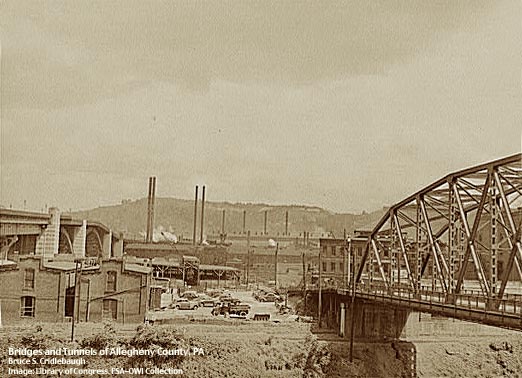
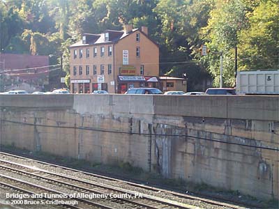
View south toward Herrs Island OFFICIAL NAME: OTHER DESIGNATION: Herr's Island Bridge (30th St Bridge] pghe586-17x LOCATION: Pittsburgh USGS 7.5" Topo Quad - UTM Coordinates: Pittsburgh East - Zone 17; 0586 4479 CARRIED: motor vehicles, 2 lanes BETWEEN: -- River Av on right descending bank of Allegheny River -- Herr's Island in Allegheny River CROSSED: -- back channel of Allegheny River mile 2.5 at Herr's Island TYPE OF CONSTRUCTION / DESIGN: LENGTH OF MAIN SPAN: TOTAL LENGTH (including longest elevated ramp): HEIGHT OF DECK: YEAR ERECTED / ENGINEER: 1939 ADDITIONAL INFO: The main channel portion of the 30th St Bridge was destroyed by fire in 1921. A temporary cable suspension bridge was built for pedestrians while the current bridge at 31st St was completed. The remaining back channel portion of the 30st St Bridge was replaced in 1939. This bridge was replaced by the current structure in 1986. The concrete wall lining East Ohio St and the retaining wall above the railroad [NS, former Conrail and PRR] show evidence of the opening of the old 30th St Bridge. FIELD CHECKED: INFO SOURCES: Submit info or inquiry - share some facts or ask a question. Introduction -- Nearby Structures Page created: Last modified: 07-Feb-2001 |
View Larger Map 
| |
| copyright: © Bruce S. Cridlebaugh 1999-2008 All Rights Reserved | |||