| Home > All By Location regional map > Pittsbugh East > Herrs Island Bridge 30th St 1887 | ||||
|
|
View north
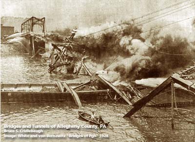
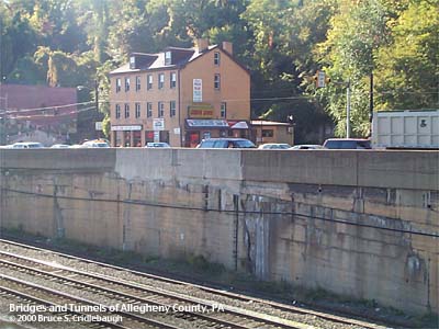
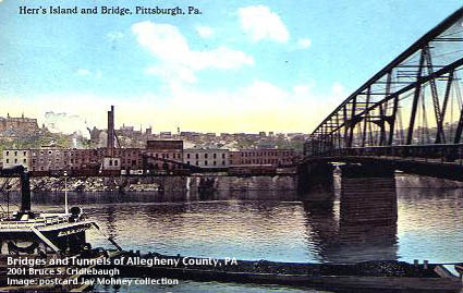
OTHER DESIGNATION: Herr's Island Bridge (30th St] pghe586-17x LOCATION: Pittsburgh USGS 7.5" Topo Quad - UTM Coordinates: Pittsburgh East - Zone 17; 0586 4479 CARRIED: Thirtieth St BETWEEN: -- River Av on right descending bank of Allegheny River -- Herr's Island in Allegheny River -- 30th St on left descending bank of Allegheny River CROSSED: -- main channel and back channel of Allegheny River mile 2.5 at Herr's Island TYPE OF CONSTRUCTION / DESIGN: through truss LENGTH OF MAIN SPAN: TOTAL LENGTH (including longest elevated ramp): HEIGHT OF DECK: YEAR ERECTED / ENGINEER: 1887 ADDITIONAL INFO: This bridge built in 1887 crossed at this location until it was destroyed by fire in 1921. It was the first highway bridge to cross the full width of the Allegheny River at Herr's Island, and linked to 30th in the Strip District. [The B&O, Pittsburgh Junction RR bridge was completed three years earlier.] The concrete wall lining East Ohio St and the retaining wall above the railroad [NS, former Conrail and PRR] show evidence of the opening of the 30th St Bridge. The back channel portion was replaced in 1939 and again in 1986 with the current structure. The main channel portion of the 30th St Bridge was destroyed by fire in 1921. A temporary cable suspension bridge was built for pedestrians while the current bridge at 31st St was completed. The island was settled by Benjamin Herr who operated a water powered mill in the back channel. Federal regulations required that livestock being transported by railroad must be given rest stops. Stockyards were constructed on Herr's Island. Over time, the stockyards were expanded; slaughterhouses and processing factories covered the island. Later the stockyards were closed and replaced by warehouses. Sculling teams from local universities discovered the still waters of the back channel and used this area for training. Herr's Island was rechristened Washington's Landing by the City of Pittsburgh as part of the clean-up and rehabilitation of the former industrial brownfield site. A new 30th Street bridge was built for reliable access. With the raised environmental conciousness of the early 1990s, Herr's Island was rediscovered, cleared and cleaned as part of a residential and recreational development which includes a marina, recreational trails and riverside park areas. The former West Penn (PRR) railroad bridge at the downstream tip of the island has been converted to pedestrian use, and includes an accessible switchback ramp at its western end. FIELD CHECKED: INFO SOURCES: Submit info or inquiry - share some facts or ask a question. Introduction -- Nearby Structures Page created: Last modified: 12-Jun-2001 |
View Larger Map 
| ||
| copyright: © Bruce S. Cridlebaugh 1999-2008 All Rights Reserved | ||||