| Home > All By Location regional map > Pittsbugh East > Sixteenth Street Bridge | |||
|
|
View south on Bates St 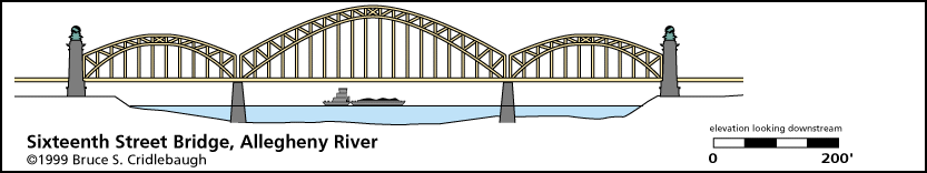
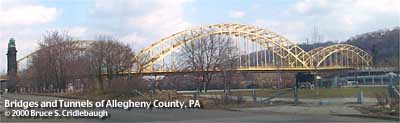
Elevation drawing looking downstream More detail photos OFFICIAL NAME: Sixteenth Street Bridge OTHER DESIGNATION: pghe585-3 LOCATION: Pittsburgh USGS 7.5" Topo Quad - UTM Coordinates: Pittsburgh East - Zone 17; 0585 4478 CARRIES: Sixteenth Street - four lanes wide pedestrian walkway on both sides of deck BETWEEN: -- Chestnut St, intersecting with Progress St, on right descending bank of Allegheny River -- Sixteenth St, intersecting with Penn Av, on left descending bank of Allegheny River CROSSES: -- (RDB to LDB) Mullberry Wy; Smallman St; former Pennysylvania RR produce and freight yard, pedestrian riverside walkway (former BO RR right-of-way); Allegheny River at mile 1.3; bike/hike trail; CSX (BO) RR 1 track (formerly 2 tracks); River Av; Saw Mill Wy TYPE OF CONSTRUCTION / DESIGN: Steel trussed arch, 3 main spans; through arch Warren truss on arches and crossbracing. Lattice and riveted plate girders. Deck is suspended below the arches. Approach spans: riveted plate girder deck on riveted plate girder bents. LENGTH OF MAIN SPAN: center span: 437 ft; 420 ft horizontal clearance north arch span 240 ft est.; south arch span 240 ft est. TOTAL LENGTH (including longest elevated ramp): 1996 ft est. [including approach spans, estimated as follows: simple span on concrete piers near Progress St 96; eight simple spans on steel bents (2-9) 32, 32, 32, 32, 32, 24, 48, 32; masonry pylon 16; north arch span 240; north channel pier 8; channel arch span 420; south channel pier 8; south arch span 240; masonry pylon 16; fifteen simple spans on steel bents (13-28) 480; simple spans crossing Smallman St 32, 48; four simple spans on steel bents to Penn Av abutment 32, 32, 32, 32] HEIGHT OF DECK: 41.3 ft clearance Emsworth Dam normal pool level 710 ft YEAR ERECTED / ENGINEER: 1923, County of Allegheny H.G. Balcom (New York), engineer Warren and Wetmore (New York), architects Rehab in 2003 included structural steel replacement and repairs, sidewalk and partial concrete deck replacement, new handrail and barrier installation, abrasive blasting and painting, and restoration of the bronze monuments that sit atop the granite piers. ADDITIONAL INFO: Sixteenth Street was originally called Mechanic St. The previous bridge at this location was a wooden covered bridge with as few as four arch trusses. It was destroyed by fire in April 1919 and was the last standing covered bridge in the city. The current bridge opened October 9, 1923 and cost $1,250,000. The bronze winged seahorses and armillary spheres by New York sculptor Leo Lentilli had not yet been placed when the bridge was dedicated. Each of the four groups had to be shipped from Michaels Art Bronze Company of Kentucky and were too wide to be transported by rail. Two arrived by truck, while the other two arrived via the river. Each group includes 4 horses. The pylon sculptures are based on a fountain on Avenue de l'Observatoire in Paris. "The Four Quarters of the World" was the last major work by Jean-Baptiste Carpeaux (1827-1875). 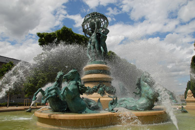
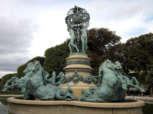
Just below the bronze sculptures, a frieze of 6 fish is carved in a band approximately four feet high encircling the top of each pylon. The pylons rise approximately 62 feet above the bridge deck. The pedestrian walkway passes through an arched opening in each pylon; above the arched passage are stone carvings of a bearded man (Poseidon/Neptune) and a woman (wife/consort). These same faces appear on opposite pylons at each end of the bridge. The bridge as built was the second design submitted by New York architects Warren and Wetmore; the first included a victory memorial with triumphal arches at each portal. This first design was rejected by the Pittsburgh Art Commission which used its authority to encourage artistic building of several new bridges during this time. These include the Sixth, Seventh and Ninth Street Bridges, the 31st Street Bridge, Washington Crossing Bridge at 40th Street. The federal government had issued requirements that several bridges must be raised or replaced for easier passage of river traffic. Mounted on the southwest and northest pylons, a plaque reads:
Stencil numbers on the steel members at each end of the bridge read: AL-05-13 OCT 1978 At the time it was constructed, this would have been "Allegheny County Bridge Number 5 - Allegheny River." The deck surface is concrete. Lighting was originally mounted on steel ornamental brackets attached to the vertical members. These light have been removed and replaced by modern lamp fixtures. The bridge was previously painted silver and green; currently all steel on bridge is painted yellow. In 1978, attempts were made at restoration of the pylon bronzes and as a result two are oxidized green while two are dark brown. Contractors were working on repainting the superstructure and thought it proper to strip the natural, self-protective, blue-green verdigris patina from the bronze and apply several coats of bronze-colored lacquer. When historians and sculpture experts noticed what was happening, the "cleaning" process was halted. It was estimated at the time that the lacquer would wear away and allow the bronze to resumes its weathering. That was 1978; there has been little change. The incident led to an end to Public Works well-intentioned procedures that had also resulted in other Schenley Park bronzes being painted: "Ode to Nature" at Schenley Plaza, Robert Burns near Phipps Conservatory and the Panther Hollow Bridge panthers. The north approach crosses the former location of the Pennsylvania Railroad produce yard and is adjacent to the 5-block-long PRR Fruit Auction and Sale Building. Buncher Corp. issued plans to build a residential development in empty land along the riverfront upstream. The plan included the demolition of about one-third of the PRR Auction building, between 16th and 17th streets. Lock and Dam No. 1, built in 1902, was located at 21st St. It was removed when the Emsworth Dam (1922) was built, thus providing the pool for the Pittsburgh Point area up to the Highland Park Bridge area. FIELD CHECKED: 17-Jun-1999 INFO SOURCES: USACE Allegheny River Nav. Charts; Gay and Evert: "Discovering Pittsburgh's Sculpture;" Kidney: "Pittsburgh's Landmark Architecture;" Kobus and Consoli, "The Pennsy in The Steel City"; Pittsburgh Post-Gazette Submit info or inquiry - share some facts or ask a question. Introduction -- Nearby Structures Page created: Last modified: 07-Feb-2001, 23-Feb-2012 |
View Larger Map View Larger Map 
| |
| copyright: © Bruce S. Cridlebaugh 1999-2012 All Rights Reserved | |||