| Home > All By Location regional map > Pittsbugh East > Fort Wayne Railroad Bridge | |||
|
|
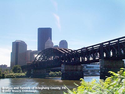
View south from North Shore 
Elevation drawing looking downstream More detail photos OFFICIAL NAME: Bridge No. 1, Pittsburgh, Fort Wayne and Chicago Railway OTHER DESIGNATION: Fort Wayne Railroad Bridge pghe585-12 LOCATION: Pittsburgh USGS 7.5" Topo Quad - UTM Coordinates: Pittsburgh East - Zone 17; 0585 4477 CARRIES: Conrail - two tracks on upper deck; lower deck not used BETWEEN: -- near Hope St on right descending bank of Allegheny River -- near Eleventh St on left descending bank of Allegheny River CROSSES: -- (LDB to RDB) Ft. Duquesne Blvd; Allegheny River at mile 1.0; River Ave TYPE OF CONSTRUCTION / DESIGN: Steel Pratt Pennsylvania truss; two decks; built for three tracks wide, but only two installed. LENGTH OF MAIN SPAN: 319 ft clear span TOTAL LENGTH (including longest elevated ramp): 985 ft, 5 spans HEIGHT OF DECK: 40.9 ft Emsworth Dam normal pool level 710 ft YEAR ERECTED / ENGINEER: 1901-04; deck elevation raised 1918 Pennsylvania Railroad ADDITIONAL INFO: This is the fifth bridge near this location. The first bridge was a wooden covered aqueduct built in 1829; it was designed by S. Lothrop and cost $104,000. It was part of the Main Line of Public Works (Pennsylvania Canal) completed across the state in 1834. This line connected to a tunnel completed in 1829 at a cost of $61,000 under Grant's Hill and led to a pool near the Monongahela River. The canal tunnel's north portal was near the north portal of the Panhandle rail tunnel, which is now used as part of the Subway "T" system. But while the canal tunnel angled farther east to a south portal near Shingiss St and Diamond St., the railroad tunnel leads to a south portal near Forbes Av and Try St. John Roebling, creator of the Brooklyn Bridge, Pittsburgh's second Smithfield St Bridge and second Seventh St Bridge, built a wire rope aqueduct bridge in 1845 to replace the covered wooden structure. This was his first suspension bridge and cost $62,000. It had seven spans of 160 ft each; the waterway was approximately 15 ft wide and 8.5 ft deep. Another Roebling suspension-type aqueduct bridge, built in 1848, still crosses the Delaware River at Minisink Ford. These aqueduct bridges aligned with 11th St in the Triangle and Voeghtly St. on the Northside. As the railroad came to Pittsburgh, it was able to make the canal obsolete. The third bridge, built just downstream from the canal bridge, was a wooden structure built in 1857 for the Pittsburgh, Fort Wayne and Chicago Railroad. It completed the rail route from Chicago to Pittsburgh. Service from points west had been available in Allegheny City (Northside) previously, but due to political considerations, the link across the Allegheny River was delayed. The bridge was not opened until a year after its completion. The fourth bridge was a wrought iron lattice truss built completed in 1868 for the Pittsburgh, Fort Wayne and Chicago Railroad. It had 5 lattice truss spans and 2 plate girder simple spans at each approach. The current bridge was built for the railroad in 1901-04 by American Bridge Co. The lattice bridge remained in place during construction of the new bridge and the piers of the new bridge were extended from the piers of the old. The old piers have since been removed. The Pennsylvania Railroad raised the bridge deck in 1918 to allow for river traffic. Concrete tops above original stone piers show evidence of the 1918 raising. Other structures leading to the bridge were raised as well, including the Duquesne Elevated which ran along the current location of Ft. Duquesne Blvd until the 1950s. The bridge currently carries Amtrak passenger via Union Station at Liberty Av and 11th St and Conrail (NS) freight traffic. Former connections from the south end of the bridge included the Penn St yard (convention center), previous Union Station at Grant St and Liberty Av (Federal Bldg), PRR produce yard (Strip District along Smallman St near 16th St), Allegheny Valley RR, and Conemaugh Division PRR. Many of the walls, abutments, steps and other traces of the old connection are still visible at the south portal. Expansion of the Convention Center will likely alter some of the area. FIELD CHECKED: 09-Jun-99 INFO SOURCES: USACE Allegheny River Nav. Charts; National Park Service website, Kobus and Consoli, "The Pennsy in The Steel City" and "The Pennsylvania Railroad's Golden Triangle" Submit info or inquiry - share some facts or ask a question. Introduction -- Nearby Structures Page created: Last modified: 03-Nov-2000 |
View Larger Map View Larger Map 
| |
| copyright: © Bruce S. Cridlebaugh 1999-2008 All Rights Reserved | |||