| Home > All By Location regional map > Pittsbugh East > Pennsylvania Canal Allegheny Aqueduct 1845 | |||
|
|
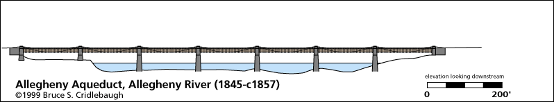
Elevation drawing looking downstream 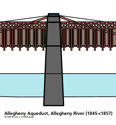
Detail at pier OFFICIAL NAME: OTHER DESIGNATION: Allegheny Aqueduct pghe585-12x2 LOCATION: Pittsburgh USGS 7.5" Topo Quad - UTM Coordinates: Pittsburgh East - Zone 17; 0585 4477 CARRIED: Pennsylvania Mainline of Public Works [Pennsylvania Canal] BETWEEN: -- near Voeghtly St on right descending bank of Allegheny River -- near Eleventh St [Washington St] on left descending bank of Allegheny River CROSSED: -- Allegheny River at mile 1.0 TYPE OF CONSTRUCTION / DESIGN: wire rope suspension, wooden truss members and aqueduct channel. LENGTH OF MAIN SPAN: 162 ft clear span TOTAL LENGTH (including longest elevated ramp): 7 spans HEIGHT OF DECK: YEAR ERECTED / ENGINEER: 1844-45; John A. Roebling ADDITIONAL INFO: This was the second bridge near this location. The first bridge was a wooden covered aqueduct built in 1829. It was part of the Main Line of Public Works (Pennsylvania Canal) completed across the state in 1834. This line connected to a tunnel completed in 1829 at a cost of $61,000 under Grant's Hill and led to a pool near the Monongahela River. The canal tunnel's north portal was near the north portal of the Panhandle rail tunnel, which is now used as part of the Subway "T" system. But while the canal tunnel angled farther east to a south portal near Shingiss St and Diamond St., the railroad tunnel leads to a south portal near Forbes Av and Try St. John Roebling, creator of the Brooklyn Bridge, Pittsburgh's second Smithfield St Bridge and second Sixth St Bridge, completed the wire rope aqueduct bridge in 1845 to replace the covered wooden structure. It was completed in nine months - - and was opened one month after the devasting fire that destroyed most of the downtown area of Pittsburgh. This was his first suspension bridge and cost $62,000. It had seven spans of 162 ft each; the waterway was approximately 15 ft wide and 8.5 ft deep. Another Roebling suspension-type aqueduct bridge, built in 1848, still crosses the Delaware River at Minisink Ford. These aqueduct bridges aligned with 11th St in the Triangle and Voeghtly St. on the Northside. The drawings are a composite from historical sketches and photos combined with photos of the Roebling aqueduct as restored by the National Park Service at Lackwaxen, PA (Minisink Ford). As the railroad came to Pittsburgh, it was able to make the canal obsolete. The third bridge, built just downstream from the canal bridge, was a wooden truss structure built in 1857 for the Pittsburgh, Fort Wayne and Chicago Railroad. FIELD CHECKED: 09-Jun-1999 INFO SOURCES: USACE Allegheny River Nav. Charts; National Park Service website, Kobus and Consoli, "The Pennsy in The Steel City" and "The Pennsylvania Railroad's Golden Triangle" Submit info or inquiry - share some facts or ask a question. Introduction -- Nearby Structures Page created: Last modified: 19-April-2001 |
View Larger Map 
| |
| copyright: © Bruce S. Cridlebaugh 1999-2008 All Rights Reserved | |||