| Home > All By Location regional map > Pittsbugh East > Birmingham Bridge at 10th St 1861 | |||
|
|
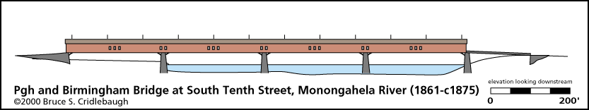
Elevation drawing looking downstream OFFICIAL NAME: Pittsburgh Birmingham Bridge Birmingham Bridge OTHER DESIGNATION: LOCATION: Pittsburgh USGS 7.5" Topo Quad - UTM Coordinates: Pittsburgh East - Zone 17; 0585 4476 CARRIED: vehicles BETWEEN: -- Cross St over B&O RR at Second Av on right descending bank of Monongahela River -- South Tenth St [formerly McKee St, renamed 1868] on left descending bank of Monongahela River CROSSED: Monongahela River at mile 1.5 TYPE OF CONSTRUCTION / DESIGN: wooden covered LENGTH OF MAIN SPAN: TOTAL LENGTH (including longest elevated ramp): HEIGHT OF DECK: YEAR ERECTED / ENGINEER: c1861 replaced 1875 ADDITIONAL INFO: The charter for the construction of a bridge between Kensington (Pittsburgh) and Birmingham (South Side) was given in 1837 and stock was offered for sale. But White's "Bridges of Pittsburgh" notes the first bridge crossing here was not opened until 1861. FIELD CHECKED: INFO SOURCES: 1874 Hopkins plot maps; Harris "Pittsburgh business directory...1837" Submit info or inquiry - share some facts or ask a question. Introduction -- Nearby Structures Page created: Last modified: 20-Jun-2001 |
View Larger Map 
| |
| copyright: © Bruce S. Cridlebaugh 1999-2008 All Rights Reserved | |||