| Home > All By Location regional map > Pittsbugh East > Parkway East Int - Grant St | |||
|
|
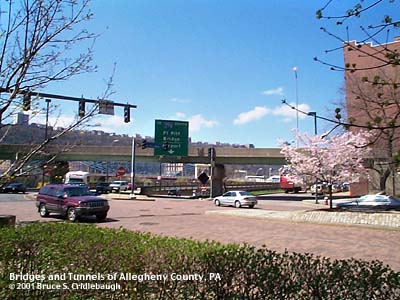
View southwest from Grant St More photos of Parkway East - Grant St interchange More information about Fort Pitt Blvd OFFICIAL NAME: Penn Lincoln Parkway East - Interchange 3 - Grant St [mileage-based interchange #1C] SR8002 OTHER DESIGNATION: [formerly SR8095?] LOCATION: Pittsburgh USGS 7.5" Topo Quad - UTM Coordinates: Pittsburgh East - Zone 17; 0584 4476 CARRIES: [SR8002] connections with Grant St and Fort Pitt Blvd: -- westbound exit from Parkway East to Fort Pitt Blvd westbound and Grant St -- westbound entrance to Parkway East from Grant St -- eastbound entrance to Parkway East from Blvd of Allies at Grant St eastbound -- eastbound exit from Parkway East to Grant St and Fort Pitt Blvd -- connection from Fort Pitt Blvd eastbound to Grant St -- eastbound entrance to Parkway East from Wood St BETWEEN: CROSSES: -- Penn Lincoln Parkway [I-376, US22, US30]; ramp from Fort Pitt Blvd at Wood St to Parkway East eastbound TYPE OF CONSTRUCTION / DESIGN: steel girder on reinforced concrete columns and bents steel girder on hammerhead piers concrete rigid frame with earthen cover (underpasses) LENGTH OF MAIN SPAN: TOTAL LENGTH (including longest elevated ramp): HEIGHT OF DECK: YEAR ERECTED / ENGINEER: 1958, PA Dept of Highways ADDITIONAL INFO: The construction of this interchange was one of the final links in completing the Penn Lincoln Parkway East. Other structures along the route had been constructed as early as 1950, but the Baltimore and Ohio Railroad passenger depot stood at the intersection of Smithfield St and Fort Pitt Blvd. The depot and the train yard stretched upriver past the South Tenth St Bridge, occupying the logical path to connect downtown with the new highway. The B&O RR agreed in August,1951, to move its facilities and by November, 1954, they had decided against building a large central office building -- opting for a new, smaller depot at Grant St and First Av. The shape of the parcel of land conformed to the new highway ramps at Grant St. Various factors contributed to the decline and eventual closing of the second B&O depot. In 2001, PNC opened an Operations Center on this same land -- with the new building also conforming to the shape of the lot. Ultimately all of the railroad tracks were removed and the former right-of-way was converted to the Eliza Furnace Recreation Trail. The presence of the original B&O terminal had cut short the extension of the 1940 Fort Pitt Blvd design. But with the demolition, the boulevard was extended and intertwined with a knot of new ramps and underpasses. In 1953, the Squirrel Hill Tunnel had been the last link in the first section to be completed, but until this interchange opened at Grant St, downtown traffic had joined the Parkway at the Blvd of the Allies interchange near Oakland. Construction on the interchange began in 1956 with the opening taking place January 17, 1958. The intersection of Fort Pitt Blvd, Grant St and several ramps resulted in a grass-covered plaza of sorts with elevated ramps curved overhead. This plaza area is landscaped, although not formally nor luxuriously. And it acts as a break in the barrier formed by the Parkway -- allowing homeless persons to access the Monongahela riverfront. There are several encampments below the ramps and along the river bank. A long flyover ramp carries eastbound traffic from Grant St and Blvd of the Allies toward the Parkway East. Facing the westbound lanes of Fort Pitt Blvd on the concrete abutment of this ramp, a series of small plaques commemorates some of the homeless people who have lived in downtown Pittsburgh. More info on Fort Pitt Blvd. FIELD CHECKED: INFO SOURCES: Lorant's "Pittsburgh" Submit info or inquiry - share some facts or ask a question. Introduction -- Nearby Structures Page created: Last modified: 16-April-2001 |
View Larger Map View Larger Map 
| |
| copyright: © Bruce S. Cridlebaugh 1999-2008 All Rights Reserved | |||