| Home > All By Location regional map > Oakdale > State St over Robinson's Run, North Branch | |||
|
|
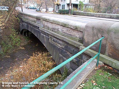
View south (downstream) from Oakdale Veterans Memorial More detail photos OFFICIAL NAME: Allegheny County Bridge No. 1 Robinson's Run North Branch OTHER DESIGNATION: East State St over Robinson's Run, North Branch Noblestown Rd No. 6 oakd569-7 LOCATION: Oakdale USGS 7.5" Topo Quad - UTM Coordinates: Oakdale - Zone 17; 0569 4472 CARRIES: East State St [Noblestown Rd] BETWEEN: -- Union Av [PA978, Orange Belt] -- Bridge Av CROSSES: -- North Branch of Robinson's Run TYPE OF CONSTRUCTION / DESIGN: concrete arch with stone facing locally-quarried sandstone outer spandrel wall: rock-faced coursed ashlar upper walls and parapets: dressed coursed ashlar arch ring: dressed stepped voussoirs in segmental arch LENGTH OF MAIN SPAN: 49 ft TOTAL LENGTH (including longest elevated ramp): 74.5 ft 44.5 ft wide, between parapets at center includes 30 ft roadway and two sidewalks HEIGHT OF DECK: YEAR ERECTED / ENGINEER: 1921, Allegheny County James G. Chalfant, County Engineer ADDITIONAL INFO: Numerous small stone arch bridges were built under the tenure of Charles Davis as County Engineer. Upon the death of Davis in 1907, James Graham Chalfant was elected to the position of County Engineer. Two of the projects undertaken by Chalfant were the reconstruction and widening of stone arch bridges of Davis: Beaver Rd over Big and Little Sewickley Creeks, 1919 and 1918 respectively. In those projects, the stonework design which may be seen as Davis' signature was retained, but the reconstruction of the bridges were done as concrete arch. When the time came to build new bridges over streams elsewhere within the county, Chalfant evolved from the Roman simplicity of Davis. These bridges mark the introduction of stepped voussoirs along the arch ring. Other details in the stonework continued to echo the Davis design: rock-faced, coursed ashlar and rounded parapets. But the major change evident in the new structures is the use of the filled concrete arch -- the stonework is mainly a decorative covering. While nearly two dozen of the small stone spans by Davis still exist, perhaps half that number remain of the Chalfant design. The pair of bridges at the center of Oakdale Borough -- about 75 feet above the confluence of the North and South Branches of Robinson's Run -- share a similar design. The State St bridge was built in 1921, the year prior to Chalfant's death. After V.R. Covell became Allegheny County's third County Engineer, evidently only one more bridge of this design was built: Union Av over Robinson's Run in Oakdale (1925). Beginning about 1910, new county bridges were being constructed solely in concrete using a design which mimicked the earlier stone arches. A metal plaque is embedded at the center of the downstream parapet:
The town of Oakdale was formed from parts of North and South Fayette townships amid oil and coal fields. It was laid out as a village by C.H. Love and incorporated in 1872. Oakdale Station was on the Panhandle Railroad. This rail line was part of the route built by the Pittsburgh and Steubenville Railroad Company (1858), a division of the Pittsburgh, Cincinnati, Chicago and St. Louis Railroad. The "Steubenville Extension" was later absorbed into the Pennsylvania Railroad -- completed into downtown Pittsburgh in 1863 . In 1865, this line connected west to Steubenville, OH, crossing the "panhandle" of Virginia (West Virginia after the Civil War), thus the source of the nickname of the railroad. FIELD CHECKED: 3-Nov-2002 INFO SOURCES: field check; Fleming, Vol. 3 History of Pittsburgh and environs, 1922; Kobus & Consoli, The Pennsylvania Railroad's Golden Triangle Submit info or inquiry - share some facts or ask a question. Introduction -- Nearby Structures Page created: Last modified: 21-Mar-2003 |
View Larger Map 
| |
| copyright: © Bruce S. Cridlebaugh 1999-2008 All Rights Reserved | |||