| Home > All By Location regional map > New Kensington West > PA Turnpike Allegheny Valley Interchange, Ramp F | |||
|
|
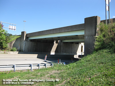
View northeast More detail photos OFFICIAL NAME: WB-422B; MP 47.81 PENNDOT BMS NUMBER: 027076990047810 OTHER DESIGNATION: PA Turnpike Allegheny Valley Interchange #48, Ramp F over Freeport Rd Northbound entrance to toll plaza LOCATION: Harmar Twp. LATITUDE, LONGITUDE: 40.540166, -79.825037 USGS 7.5" Topo Quad - UTM Coordinates: New Kensington West - Zone 17; 0599 4488 CARRIES: -- Northbound entrance to toll plaza, 1 lane BETWEEN: -- from northbound Freeport Rd -- Allegheny Valley Interchange #48 CROSSES: -- Freeport Rd [SR1001] TYPE OF CONSTRUCTION / DESIGN: deck steel stringer LENGTH OF MAIN SPAN: 82 ft TOTAL LENGTH (including longest elevated ramp): 82 ft HEIGHT OF DECK: 14.5 ft clearance; 33 ft width YEAR ERECTED / ENGINEER: 1951, Buchart Horn engineers for Western Extension Pennsylvania Turnpike Commission Rehab 1996 ADDITIONAL INFO: FIELD CHECKED: 13-Sep-2009 INFO SOURCES: field check Submit info or inquiry - share some facts or ask a question. Introduction -- Nearby Structures Page created: 10-Aug-2009 Last modified: 14-Sep-2009 No warranty whatsoever -- express or implied -- as to the accuracy, reliability or completeness of furnished data. |
View Larger Map View Larger Map 
| |
| copyright: © Bruce S. Cridlebaugh 1999-2009 All Rights Reserved | |||