| Home > All By Location regional map > New Kensington West > PA Turnpike over Allegheny Valley Interchange #48 Ramps | |||
|
|
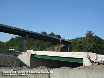
New bridge (foreground) to carry realigned Turnpike to new Allegheny River Bridge More detail photos OFFICIAL NAME: WB-442A; MP 47.60 PENNDOT BMS NUMBER: 027076990047600 OTHER DESIGNATION: PA Turnpike over Allegheny Valley Interchange #48 Ramps LOCATION: Harmar Twp. LATITUDE, LONGITUDE: 40.543472, -79.823428 USGS 7.5" Topo Quad - UTM Coordinates: New Kensington West - Zone 17; 0599 4488 CARRIES: -- PA Turnpike [I-76], 4 lanes BETWEEN: -- MP 47.60 -- Allegheny Valley Interchange #48 toll plaza -- access to and from PA Turnpike westbound CROSSES: -- Ramps (access to and from PA Turnpike westbound), 2 lanes TYPE OF CONSTRUCTION / DESIGN: deck steel stringer LENGTH OF MAIN SPAN: 48 ft TOTAL LENGTH (including longest elevated ramp): 48 ft HEIGHT OF DECK: 17 ft clearance; 87 ft width YEAR ERECTED / ENGINEER: 1951, Buchart Horn engineers for Western Extension Pennsylvania Turnpike Commission Rehab 1992 Replaced 2009 ADDITIONAL INFO: FIELD CHECKED: - INFO SOURCES: field check Submit info or inquiry - share some facts or ask a question. Introduction -- Nearby Structures Page created: 10-Aug-2009 Last modified: 09-Sep-2009 No warranty whatsoever -- express or implied -- as to the accuracy, reliability or completeness of furnished data. |
View Larger Map 
| |
| copyright: © Bruce S. Cridlebaugh 1999-2009 All Rights Reserved | |||