| Home > All By Location regional map > Murrysville > Center-New Texas Rd over Little Plum Creek Run | |||
|
|
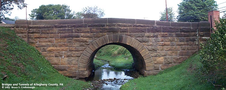
View north (downstream) toward Center-New Texas Rd More detail photos OFFICIAL NAME: OTHER DESIGNATION: Center-New Texas Rd [old alignment] over Little Plum Creek Cemetary Ln over Little Plum Creek murr606-2 LOCATION: Plum USGS 7.5" Topo Quad - UTM Coordinates: Murrysville - Zone 17; 0606 4482 CARRIES: -- Plum Creek Cemetary entrance -- old alignment of Center-New Texas Rd BETWEEN: -- west of intersection at New Texas Rd [Orange Belt] CROSSES: -- Little Plum Creek TYPE OF CONSTRUCTION / DESIGN: stone arch locally-quarried sandstone outer spandrel wall: rock-faced coursed ashlar upper walls and parapets: dressed coursed ashlar arch ring: dressed voussoirs in semicircular arch LENGTH OF MAIN SPAN: 12 ft TOTAL LENGTH (including longest elevated ramp): 43.5 ft 18.5 ft wide, between parapets HEIGHT OF DECK: YEAR ERECTED / ENGINEER: 1902, Allegheny County Charles Davis, county engineer ADDITIONAL INFO: This bridge exhibits the more common design features of the County's stone bridges -- parapets with rounded top and horizontal curves at the portals. This is one of the best preserved structures of its type in the county. It is also in location which is easy to visit and view up close. There is evidence of repointing and some damage to a few stones. And unfortunately, the all-too-common spraypainted graffiti. While most of these bridges were segmental arches, this and the nearby bridge at Old Leechburg Rd are semicircular Roman arches. The route of Center-New Texas Rd was moved about one hundred feet to the south and crosses Little Plum Creek over a section of corrugated steel pipe. The stone arch bridge has been adopted by the Plum Creek Cemetary as its main entrance from New Texas Rd. The juxtaposition of the structures leads to comparison of craftsmanship versus expedience. FIELD CHECKED: 01-Oct-2002 INFO SOURCES: field check Submit info or inquiry - share some facts or ask a question. Introduction -- Nearby Structures Page created: Last modified: 29-Oct-2002 |
View Larger Map View Larger Map 
| |
| copyright: © Bruce S. Cridlebaugh 1999-2008 All Rights Reserved | |||