| Home > All By Location regional map > Monongahela > Williamsport Bridge 1836-1910 | |||
|
|
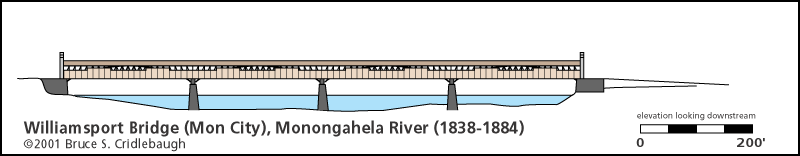
1836 bridge: Elevation drawing looking downstream 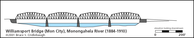
1884 bridge: Elevation drawing looking downstream More detail photos OFFICIAL NAME: Williamsport Bridge OTHER DESIGNATION: LOCATION: Monongahela, Washington Co. - Forward Twp., Allegheny Co. USGS 7.5" Topo Quad - UTM Coordinates: Monongahela - Zone 17; 0591 4450 CARRIED: motor vehicles BETWEEN: -- Devore's (Forward Twp., Allegheny Co.) on right descending bank of Monongahela River -- Williamsport (Parkison's Ferry)(Monongahela City, Washington Co.) on left descending bank of Monongahela River CROSSED: -- Monongahela River at mile 33.2 TYPE OF CONSTRUCTION / DESIGN: wooden covered on stone piers, four spans superstructure replaced in 1884 with metal camelback Pratt through truss on original piers, four spans LENGTH OF MAIN SPAN: TOTAL LENGTH (including longest elevated ramp): 921 ft HEIGHT OF DECK: YEAR ERECTED / ENGINEER: 1836-38, rebuilt 1884, replaced 1910 William Pagan and Robert Alton [Alston] - stonework Lothrop & Stockton - superstructure [Other sources also mention architects and builder Le Barron and Swan. Bridge officers Van Kirk and Mills operated steam saw mills nearby.] ADDITIONAL INFO: This was the first bridge to cross the Monongahela River at the city which shares its name with the river. Parkison's Ferry and Williamsport were the previous names of the town; the name was changed to Monongahela City, April 1, 1837. The narrow strip of land formed by the outflow of Pigeon Creek into the Monongahela River is known as Whiskey Point -- a prominent site from the Whiskey Rebellion (1791-1794) where farmers and political leaders protested the Federal government's excise tax on whiskey. The ferry crossed "30 perches" (495 feet) downstream from the outflow of Pigeon Creek. The charter for the bridge specified that the bridge would cross closer to Pigeon Creek. Construction on the Williamsport Bridge was begun in 1836. The massive stone abutment which carried the bridge into Mon City still stands on the river bank. The lower sections show some frost and flood damage but above the high water level, the joints remain remarkably tight. The quoted length is 921 feet. Drawings show the bridge to have had four spans. Assuming the state-of-the-art in 1836 was producing bridge spans locally of about 180 feet, the quoted length includes long approaches and an over water distance of about 720 feet. Sylvanus Lothrop, who constructed the 1838 superstructure, is noted as the engineer responsible for the 1829 Allegheny Aqueduct carrying the Pennsylvania Canal over the Allegheny River in Pittsburgh. He was also chief engineer for the Monongahela Navigation Company which made the first efforts in building a lock and dam system on the river. Lothrop and William Pagan (stonework) are also reported as involved in the construction of the Burr arch truss covered bridges at 1839 Hand St (Ninth St) and the 1838 Northern Liberties Bridge (Mechanics St, later 16th St) -- both bridges crossing the Allegheny River at Pittsburgh. Photos and drawings indicate when the Williamsport Bridge was rebuilt after a fire in 1884, its replacement was a four span metal through truss. The 1884 bridge was built on the same piers as its predecessor. This bridge was, in turn, replaced in 1910 by an entirely new metal through truss of three spans which crossed about 500 feet downstream until 1988. excerpt from Boyd: David Devore...and his brother Moses Devore purchased in 1788, 250 acres of land, lying opposite Monongahela City, which land was then in Westmoreland County, now Forward township, Allegheny county, paying 50 cents per acre with interest from March 1, 1771, agreeably to an act passed by the Assembly in 1784. David Devore was granted license to ferry from his home on this property to the mouth of Pigeon Creek, afterward known as Parkison's Ferry. He died in 1789, leaving a widow with one child, Cassandra. His widow some years afterward married Major Scott, and to her was born one son William. After the death of Mr. Scott the widow made her home with this son at Vincennes, Indiana, where she died in 1820. Cassandra Devore married George Elliott, who was drowned off the ferry while trying to rescue his son Burnside. James Manown married Mrs. George Elliott, and they resided on the farm near the Ferry which James Manown bought from Moses Devore. The Ferry belonging to his wife, James Manown afterward bought at sheriff sale the Parkison interest in land and Ferry, and carried on the Ferry until the Williamsport bridge was built in 1836. excerpts from Crumrine: On the first day of January, 1781, viewers were appointed by the Court of Quarter Sessions of Washington county to lay out a road "from Bassett Town [now Washington] to the mouth of Pigeon Creek." This immediate locality, therefore, seems to have been known as "the mouth of Pigeon Creek" and "Devore's Ferry" until 1782, when, by an act approved April 13th of that year, the landing of a ferry of Parkison and Devore---meaning Joseph Parkison and Jacobus Devore---was established, "30 perches below the mouth of Pigeon Creek." In 1832 (June 5th), Andrew B. Chess, Samuel Black, and William Mills (for James Mills) released "the president and managers of the 'Williamsport Bridge Company' (whenever the same shall have legal existence under the law creating said company) from all claims for damages for and on account of any land or soil occupied by and in the erection of said bridge, or for any landing or ferry right which we may, and do now, possess, provided said bridge shall be erected on our or either of our premises." On the 25th of June, same year, James Manown relinquished certain privileges to the above-named company, "provided the site for the bridge shall be fixed above Asher Van Kirk's white house on the Island near the mouth of Pigeon Creek." He also agreed to relinquish the privilege of continuing the ferry, except in case the bridge be destroyed. At an election held at the house of Joseph Hamilton, June 22, 1836, James Manown, John Storer, Robert F. Biddle, Asher Van Kirk, William Johnson, John McFarlane, and William Mills were chosen managers of the Williamsport Brdige Company. At the same time Samuel Devore was elected treasurer, and Robert F. Biddle secretary. Public notice was also given to bridge-builders that sealed proposals for erecting a bridge over the Monongahela River at Williamsport would be received until July 18, 1836. The bridge was completed in 1838. Williamsport Bridge Company...was chartered by an act of the State Legislature, approved March 16, 1832. In 1836 nine hundred and fifty shares were subscribed for at a par value of fifty dollars each. Of these shares Joseph Ritner, Governor of the Commonwealth, in accordance with the provisions of the act of incorporation, subscribed for three hundred chares on behalf of the State. Nicholas Biddle, president of the Bank of the United States, subscribed for three hundred shares on behalf of that bank, and the remainder of the shares (three hundred and fifty in number) were taken by citizens interested and living in the vicinity. Proposals for constructing the bridge were opened in July, 1836, and the contracts were then awarded to William Pagan and Robert Alton [Alston] for stone-work, and to Lothrop & Stockton for superstructure. [Other sources also mention architects and builder Le Barron and Swan. Bridge officers Van Kirk and Mills operated steam saw mills nearby.] The bridge was completed in 1838, at a cost of about sixty thousand dollars; and that the contractors performed honest work is attested by the fact that, though it has been a prominent landmark and in constant use for nearly a half a century, it is still in good condition. Its length is nine hundred and twenty-one feet. view page - "The Day the Bridge Caught Fire" (1836 Williamsport Bridge at Monongahela City) FIELD CHECKED: INFO SOURCES: Beers, J. H. and Co., Commemorative Biographical Record of Washington County, Pennsylvania (Chicago: J. H. Beers & Co., 1893); Crumrine, "History of Washington County, Pennsylvania with Biographical Sketches of Many of Its Pioneers and Prominent Men" (Philadelphia: L. H. Leverts & Co., 1882); Jay W. Mohney, Mon River Buffs Submit info or inquiry - share some facts or ask a question. Introduction -- Nearby Structures Page created: Last modified: 29-Apr-2002 |
View Larger Map View Larger Map 
| |
| copyright: © Bruce S. Cridlebaugh 1999-2008 All Rights Reserved | |||