| Home > All By Location regional map > McKeesport > Boston Bridge | |||
|
|
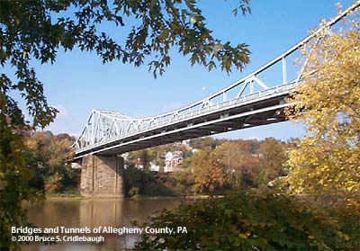
View northeast from Boston riverfront park More detail photos OFFICIAL NAME: Boston Bridge Allegheny County Bridge No. 6, Youghiogheny River OTHER DESIGNATION: LOCATION: Boston (Elizabeth Twp) - Versailles USGS 7.5" Topo Quad - UTM Coordinates: McKeesport - Zone 17; 0599 4462 CARRIES: motor vehicles, two lanes PA48, Orange Belt sidewalk each side BETWEEN: -- PA48, Orange Belt [Walnut St] at Linden St(Versailles) on right descending bank of Youghiogheny River -- PA48, Orange Belt; Smithfield St [SR2018, AC####] (Boston) on left descending bank of Youghiogheny River CROSSES: -- (RDB to LDB) CSX (former B&O RR); Yough Av; Youghiogheny River at mile 4.1; Yough River Trail [former P&LE RR] TYPE OF CONSTRUCTION / DESIGN: cantilever through truss LENGTH OF MAIN SPAN: TOTAL LENGTH (including longest elevated ramp): HEIGHT OF DECK: YEAR ERECTED / ENGINEER: 1931, County of Allegheny ADDITIONAL INFO: A metal plaque affixed to the sidewalk railing reads:
The construction of this bridge without trolley tracks was a factor leading West Penn Railways to abandon of the nearly 6 miles of street railway from Versailles to Buena Vista and Scott Haven. Boston Trail Access for Youghiogheny River Trail (bike-hike) is near the south end of bridge at Donner St. This area is located at P&LE mile 19.1 which is 4.1 river miles upstream from McKeesport. FIELD CHECKED: 23-Oct-2000 INFO SOURCES: Beal, "McKeesport Trolleys"; www.youghrivertrail.com website Submit info or inquiry - share some facts or ask a question. Introduction -- Nearby Structures Page created: Last modified: 29-Oct-2000 |
View Larger Map 
| |
| copyright: © Bruce S. Cridlebaugh 1999-2008 All Rights Reserved | |||