| Home > All By Location regional map > McKeesport > Glassport-Elizabeth Rd over Wylie Run | |||
|
|
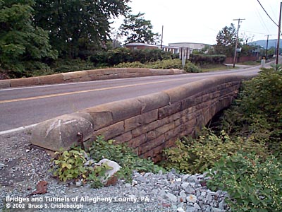
View northwest (upstream to right, Monongahela River to left) More detail photos OFFICIAL NAME: OTHER DESIGNATION: Glassport-Elizabeth Rd over Wylie Run glas595-13A, mcke595-7 LOCATION: Elizabeth Twp - Lincoln USGS 7.5" Topo Quad - UTM Coordinates: McKeesport - Zone 17; 0595 4459 CARRIES: -- Glassport-Elizabeth Rd [SR2001] [Lincoln Blvd] BETWEEN: -- north of Lovedale Rd [SR2010] and Atlantic Av CROSSES: -- Wylie Run TYPE OF CONSTRUCTION / DESIGN: stone arch locally-quarried sandstone outer spandrel wall: rock-faced coursed ashlar upper walls and parapets: dressed coursed ashlar arch ring: dressed voussoirs in segmental arch LENGTH OF MAIN SPAN: 27 ft TOTAL LENGTH (including longest elevated ramp): 63 ft 21 ft wide, between parapets HEIGHT OF DECK: YEAR ERECTED / ENGINEER: 1905, County of Allegheny Charles Davis, county engineer ADDITIONAL INFO: This bridge exhibits the more common design features of the County's stone bridges -- parapets with rounded top and horizontal curves at the portals. This is one of the few bridges of this type which includes a tablet listing the people responsible for its construction. The stone tablet is mounted on the upstream wall facing traffic and more than half buried in dirt. The tablet extends lower than the name of the engineer, but would require more serious digging in a dangerous location.
After approximately one hundred years of service, the span appears to be in good shape. There are no weight limits and Glassport-Elizabeth Road is heavily traveled. But being so narrow -- 21 feet between stone parapets -- would seem to endanger the structure's future on a busy state road. FIELD CHECKED: 29-Sep-2002 INFO SOURCES: field check Submit info or inquiry - share some facts or ask a question. Introduction -- Nearby Structures Page created: Last modified: 10-Oct-2002 |
View Larger Map View Larger Map 
| |
| copyright: © Bruce S. Cridlebaugh 1999-2008 All Rights Reserved | |||