| Home > All By Location regional map > Glenshaw > McIntyre Rd over West Branch of Deer Creek, at PA910 | |||
|
|
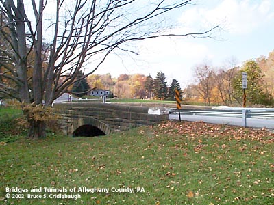
View north (downstream right) with extended retaining wall to northeast More detail photos OFFICIAL NAME: OTHER DESIGNATION: McIntyre Rd over West Branch of Deer Creek, at PA910 McIntyre Rd #2 glen591-xx LOCATION: Richland USGS 7.5" Topo Quad - UTM Coordinates: Glenshaw - Zone 17; 0591 4497 CARRIES: McIntyre Rd [T618] BETWEEN: -- Havencrest Rd -- Gibsonia Rd [PA910, Orange Belt] CROSSES: -- West Branch Deer Creek TYPE OF CONSTRUCTION / DESIGN: stone arch locally-quarried sandstone outer spandrel wall: rock-faced coursed ashlar upper walls and parapets: dressed coursed ashlar arch ring: dressed voussoirs in segmental arch LENGTH OF MAIN SPAN: 18 ft TOTAL LENGTH (including longest elevated ramp): 49 ft 18 ft wide, between parapets at center HEIGHT OF DECK: 5 ft clearance at center of arch YEAR ERECTED / ENGINEER: 1900, Allegheny County Charles Davis, County Engineer ADDITIONAL INFO: During years surrounding 1900, Allegheny County, under the direction of County Engineer Charles Davis, was busy throughout the county building stone arch bridges of a simple and similar design. This bridge exhibits the more common design features of the County's stone bridges. The design and construction details match many others still standing elsewhere in the county. The 1876 Hopkins "Atlas of Allegheny County" shows Jno. McIntyre's home just to the north of the intersection of McIntryre Rd and Allison Rd. The 1876 map also shows McIntyre Rd and Turner Rd as a more or less continuous road, but the present course of Gibsonia Rd in place only to the west. All traffic crossed the McIntyre stone bridge. Travel to the east was by way of an older road, Reichenbach Rd, roughly along the path of the recently-built Havencrest Rd. Reichenbach Rd (also spelled Reichenbaugh on the 1876 map) recrossed the West Branch of Deer Creek to meet Middle Rd to the east of Deer Creek. Other nearby bridges on the newer section of Gibsonia Rd were constructed in 1960. FIELD CHECKED: 3-Nov-2002 INFO SOURCES: field check; 1876 Hopkins atlas Submit info or inquiry - share some facts or ask a question. Introduction -- Nearby Structures Page created: Last modified: 19-Feb-2003 |
View Larger Map 
| |
| copyright: © Bruce S. Cridlebaugh 1999-2008 All Rights Reserved | |||