| Home > All By Location regional map > Glassport > W.D. Mansfield Bridge | |||||||||||||||||||||||||||||||||||||||||||||||
|
|
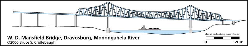
Elevation drawing looking downstream
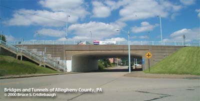
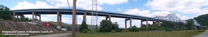
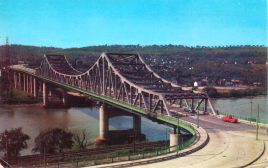
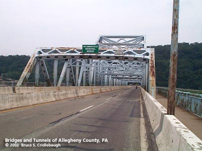
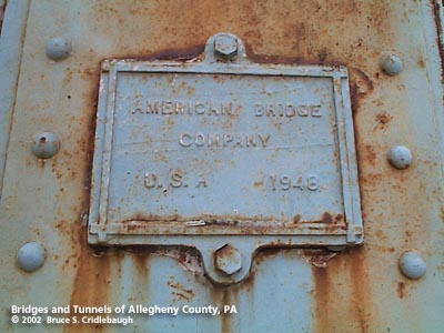
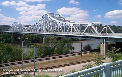
OFFICIAL NAME: W.D. Mansfield Memorial Bridge OTHER DESIGNATION: Allegheny County Bridge No. 14 Monongahela River Glassport-Dravosburg Bridge glas593-8 LOCATION: Dravosburg - McKeesport / Glassport USGS 7.5" Topo Quad - UTM Coordinates: Glassport - Zone 17; 0594 4486 CARRIES: motor vehicles, four lanes divided Richland Av; Yellow Belt sidewalks both sides BETWEEN: -- right descending bank of Monongahela River; West Fifth Av, McKeesport [Yellow Belt]; Monongahela Av, Glassport -- left descending bank of Monongahela River; Richland Av [Yellow Belt], Dravosburg CROSSES: -- (RDB to LDB) southbound lanes of West Fifth Av - Monongahela Av; CSX [PLE RR]; Monongahela River at mile 16.7; Duquesne-Dravosburg Rd [River Rd, PA837]; NS RR [Conrail]; grade separation at Maple Av TYPE OF CONSTRUCTION / DESIGN: Cantilever through truss; deck riveted steel girder viaduct LENGTH OF MAIN SPAN: 480.0 ft TOTAL LENGTH (including longest elevated ramp): 1,931 ft HEIGHT OF DECK: 65.3 ft, vertical clearance, at right pier of channel span Lock and Dam No. 2, Braddock, normal pool level 718.7 ft YEAR ERECTED / ENGINEER: 1951, County of Allegheny American Bridge Co. (plaque on bridge superstructure notes the date 1948) ADDITIONAL INFO: With light blue paint peeling off of aluminum grey, this high-level bridge doesn't exude charm and grace. But in a way, it has been frozen in time. Although safety updates have been made to the deck, including jersey barriers, most of the detailing of the structure and its approaches remain from the original design. Period lampposts, light fixtures and hardware are still in service, especially in the area of the grade separation on the Dravosburg side. Extending toward the river from the grade separation, a utilitarian girder viaduct matter-of-factly crosses the flats near the river bank in 8 spans. The river crossing uses a cantilever through truss with the upper chords curving above the piers of the 480 ft channel span. From a height of nearly 70 feet, the view from the sidewalk presents a long curve of the river which typically includes towboat traffic. Most of the industry along this section of the river has long since faded, but to the south the clouds from the USX Irvin Works and a General Motors Fisher Body plant are visible. At the McKeesport landing, the bridge and a less fussy grade separation complete the crossing -- over top of an auto wrecking yard. This approach to the bridge is much like the southern end of the Rankin Bridge. The lanes closest to the river (southbound) pass below the first span of the bridge, bypassing the deck traffic. Here West Fifth Av, McKeesport, becomes Monongahela Av, Glassport. Northbound traffic bypasses the crossing, but at deck level. Bridge traffic moves continuously with a stop sign only for the bridge traffic entering from Glassport. On the first vertical truss member on the right hand side of each portal, a small escutcheon reminds the pedestrian that this bridge was constructed by American Bridge Co. Mounted on the sidewalk railing at the southwest and northeast ends of the bridge, a plaque reads:
This bridge replaced a low-level bridge which linked McClure St in Dravosburg to John St in McKeesport [Port Vue]. FIELD CHECKED: 03-June-2000 INFO SOURCES: USACE Monongahela River Nav. Charts Submit info or inquiry - share some facts or ask a question. Introduction -- Nearby Structures Page created: Last modified: 14-June-2002 |
View Larger Map View Larger Map View Larger Map 
| |||||||||||||||||||||||||||||||||||||||||||||
| copyright: © Bruce S. Cridlebaugh 1999-2008 All Rights Reserved | |||||||||||||||||||||||||||||||||||||||||||||||